[ Archive ]
| CIMSS-NOAA Weekly Report
[ Archive ] |
IN THE PRESS:
ITEMS FOR THE ADMINISTRATOR:
ITEMS FOR THE ASSISTANT ADMINISTRATOR:
ITEMS FOR THE OFFICE DIRECTOR, ORA:
ACCOMPLISHMENTS:
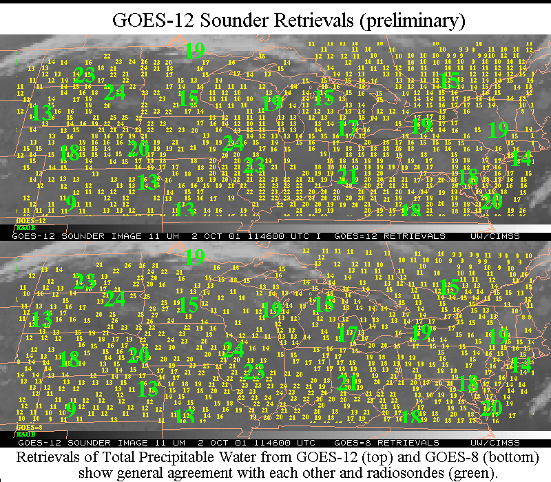
GOES-12 Sounder Retrievals Produced at CIMSS: Temperature
and moisture retrievals from the new Geostationary Operational Environmental
Satellite (GOES) -12 Sounder instrument have been produced since September
30, 2001 at the Cooperative Institute for Meteorological Satellite Studies
(CIMSS). Preliminary indications are that there is reasonable agreement
between GOES-12 and GOES-8 retrievals. Derived Product Imagery (DPI) of
total precipitable water are being displayed in real-time at
http://cimss.ssec.wisc.edu/goes/realtime/g12.
The retrieval codes and files have been made available to the Forecast
Products Development Team (FPDT). (J. Nelson III, CIMSS, 608-263-6013,
G.
Wade, E/RA2, 608-263-4743,
T.
Schmit, E/RA2, 608-263-0291)
(Click on image for full view)
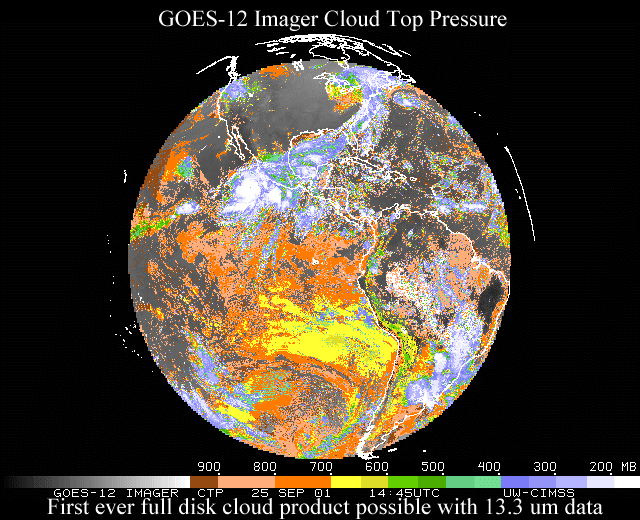
CIMSS Produces a Cloud-top Pressure Image from the GOES-12 Imager:
The Cooperative Institute for Meteorological Satellite Studies (CIMSS)
has produced a nearly full disk image of cloud-top pressure from the Geostationary
Operational Environmental Satellite (GOES) -12 Imager data. This product
has a great number of potential uses, ranging from numerical weather prediction
to aviation weather interests. In general, there is also good correlation
between this imager-based product and that product produced from the full
complement of GOES Sounder bands. For more information see: http://cimss.ssec.wisc.edu/goes/goes12/cloud_loop/anicldg12.html.
(T. Schreiner, CIMSS,
608-263-6754, T. Schmit,
E/RA2, 608-263-0291)
(Click on image for full view)
ITEMS FOR THE DIVISION CHIEF, ARAD:
ACCOMPLISHMENTS:
GOES Sounder Moisture Manuscript Accepted for Publication: The
paper entitled "Validation and use of GOES sounder moisture information"
has been accepted by the Weather and Forecasting journal. The validations
described were made with respect to co-located radiosondes, a microwave
radiometer, parallel runs of the regional Eta model, and forecaster responses.
(T. Schmit, E/RA2, 608-263-0291)
VISITORS:
NEXT WEEK:
LOOKING AHEAD:
IN THE PRESS:
ITEMS FOR THE ADMINISTRATOR:
ITEMS FOR THE ASSISTANT ADMINISTRATOR:
ITEMS FOR THE OFFICE DIRECTOR, ORA:
Nothing to report.
ITEMS FOR THE DIVISION CHIEF, ARAD:
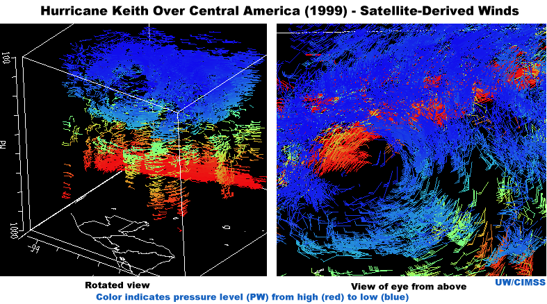
New Visualization Tools for Wind Research: The Cooperative
Institute for Meteorological Satellite Studies (CIMSS) is experimenting
with the use of new visualization tools to display high-density satellite
winds. The Visualization for Algorithm Development (VISAD) system
is being employed to provide multi-dimensional views of the datasets for
analysis, quality control, and other uses. Tests with data from Hurricane
Keith (1999) clearly illustrate the high density of satellite-derived winds
achievable around a hurricane,and offer the added perspective of the height
distribution of wind vectors. (C.
Velden, CIMSS, 608-262-9168, G. Dengel, CIMSS, 608-265-2322).
(Click on image for full view)
NEXT WEEK:
LOOKING AHEAD: