[ Archive ]
| CIMSS-NOAA Weekly Report
[ Archive ] |
IN THE PRESS:
ITEMS FOR THE ADMINISTRATOR:
ITEMS FOR THE ASSISTANT ADMINISTRATOR:
ITEMS FOR THE OFFICE DIRECTOR, ORA:
ACCOMPLISHMENTS:
Initial ECMWF Evaluation of Polar Winds: The European Centre for Medium Range Weather Forecasting (ECMWF) performed an initial evaluation of the 10-day data set of polar region winds derived from the MODerate-resolution Imaging Spectroradiometer (MODIS). N. Bormann of the ECMWF reported that they are "quite happy with the results" of their study with the polar winds and "rather impressed about the quality of the winds". (J. Key , E/RA2, 608-263-2605, C. Velden , CIMSS, 608-262-9168, D. Santek, CIMSS, 608-263-7410)
Problem with the GOES-12 Imager band 3 (6.5 um) server fixed:
With the help of R. Rabin (National Severe Storms Laboratory), a small
problem with current version of the Man computer Interactive Data Access
System (McIDAS) server for the Geostationary Operational Environmental
Satellite (GOES) VARiable (GVAR) data was discovered on the experimental
GOES-12 band 3 (6.5 microns). Lines of the water vapor band were reported
as duplicated, not showing the better spatial resolution that GOES-12 has
in this band. The Space Science and Engineering Center (SSEC) has
generated and implemented a fix. This exercise once again shows the importance
of the post-launch tests, as well as the importance of archiving this test
data in it's native format. (T.
Schmit , E/RA2, 608-263-0291, R.
Rabin , NOAA/NSSL and CIMSS, 608-264-5325/405-366-0583)
ITEMS FOR THE DIVISION CHIEF, ARAD:
ACCOMPLISHMENTS:
Conference Call on BUFR Structure for the GOES Imager Clear Sky Brightness Temperature Product: Representatives from the National Environmental Satellite, Data, and Information Service (NESDIS) and the National Centers for Environmental Prediction (NCEP) met with Simon Elliott of the EUropean organization for the exploitation of METeorological SATellites (EUMETSAT) to discuss the current and future Binary Universal FoRm (BUFR) format of the Clear-Sky Brightness Temperature (CSBT) product that is being developed. The consensus was that ultimately the same BUFR template should be used by both generating centers, although this will take coordination with the World Meteorological Organization (WMO). Before the final format is developed and approved, the current version, based on the EUMETSAT template, will be used. (T. Schmit, E/RA2, 608-263-0291, G. Callan, E/RA2, 608-263-3951)
Presentation provided for the GEWEX Radiation Conference:
A presentation on the Advanced Baseline Imager (ABI) and the Advanced Baseline
Sounder (ABS) was made available for the Global Energy and Water Cycle
Experiment (GEWEX) Radiation Panel. GEWEX is part of the World Climate
Research Program (WCRP). The file was provided to M. DeMaria of the Regional
and Mesoscale Meteorology (RAMM) Team who will give a presentation at the
November 12, 2001 meeting in Ft. Collins, Colorado. The presentation
is available upon request. (
T. Schmit , E/RA2, 608-263-0291)
VISITORS:
NEXT WEEK:
LOOKING AHEAD:
IN THE PRESS:
ITEMS FOR THE ADMINISTRATOR:
ITEMS FOR THE ASSISTANT ADMINISTRATOR:
ITEMS FOR THE OFFICE DIRECTOR, ORA:
ITEMS FOR THE DIVISION CHIEF, ARAD:
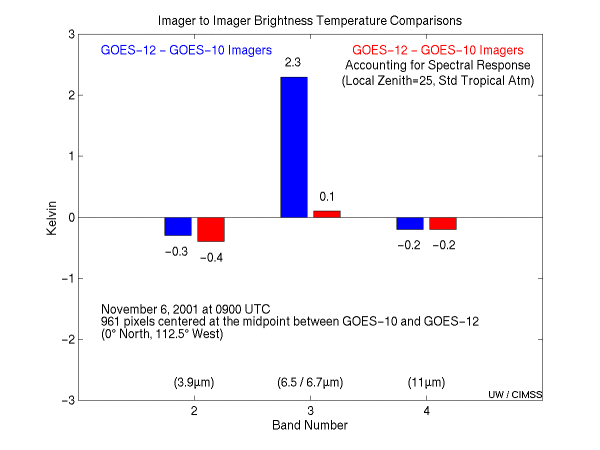
Initial GOES-12/10 Imager Brightness Temperatures Comparison: Researchers at the Cooperative Institute for Meteorological Satellite Studies (CIMSS) compared the Geostationary Operational Environmental Satellite (GOES)-12 Imager to the GOES-10 Imager at the mid-point between satellites (0N, 112.5W) on November 6, 2001 at 0900 UTC when the two imagers shared the same schedule. The results show good agreement in bands 2 (4 microns), 3 (6.7/6.5 microns), and 4 (11 microns) when the spectral responses are taken into account. The comparison was done by calculating the brightness temperature for each of the bands on both instruments with a radiative transfer model under the same conditions, then subtracting them from the averaged measured brightness temperatures for a tropical location. Brightness temperature differences (GOES-12 minus GOES-10) were -0.4 K, 0.1 K, and -0.2 K in bands 2, 3, and 4 respectively. (M. Gunshor, CIMSS, 608-263-1146, T. Schmit, E/RA2, 608-263-0291)
NWS Winter Weather Workshop: S. Bachmeier participated in the National Weather Service (NWS) Warning Decision Training Branch (WDTB) Winter Weather Workshop in Boulder, Colorado on November 6-9, 2001. The workshop was attended by forecasters from the Eastern, Central, Southern, Western, and Alaska Regions of the NWS. A presentation titled "Ingredients Based Forecasting for Winter Season Precipitation" was given at the workshop. (S. Bachmeier, CIMSS, S. Wetzel, CIMSS)
VISIT Team Meeting: On October 19, 2001 an Integrated Sensor
Training/Virtual Institute for Satellite Integration Training (IST/VISIT)
team meeting was held in Madison, Wisconsin and attended by staff from
the Cooperative Institute for Meteorological Satellite Studies (CIMSS),
the Cooperative Institute for Research in the Atmosphere (CIRA), the Warning
Decision Training Branch (WDTB), the National Weather Service (NWS), and
the National Environmental Satellite, Data, and Information Service (NESDIS).
Action items include finalizing the audio recording for the Geostationary
Operational Environmental Satellite (GOES) Sounder lesson, adding GOES
winds to one of the sessions, working with the Advanced Weather Interactive
Processing System (AWIPS) office to get the correct enhancement curves
distributed, sending the Severe Weather Operations Plan to WDTB, changing
the paradigm for selecting browse images in VISITview's Lesson Builder,
exploring how to get Interactive Forecast Preparation System (IFPS) to
the VISIT collaborators, installing software at CIMSS and CIRA, and incorporating
the new Lightning II session into the schedule. (T.
Whittaker, CIMSS, 608-262-2759)
NEXT WEEK:
LOOKING AHEAD: