[ Archive ]
| CIMSS-NOAA Weekly Report
[ Archive ] |
IN THE PRESS:
ITEMS FOR THE ADMINISTRATOR:
ITEMS FOR THE ASSISTANT ADMINISTRATOR:
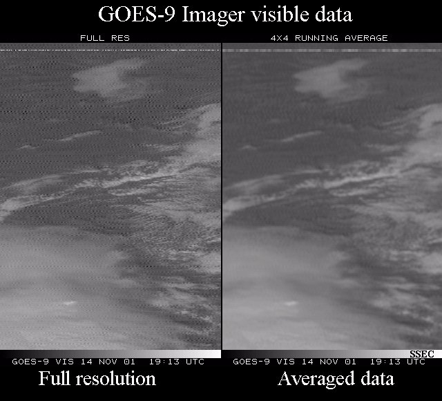
GOES-9 Imager and Sounder data investigated: In response to a
request from the National Environmental Satellite, Data, and Information
Service (NESDIS) the Space Science and Engineering Center (SSEC) ingested
Geostationary Operational Environmental Satellite (GOES)-9 imager and sounder
data when this satellite came out of storage. Data sets were made available
via the Man computer Interactive Data Access System (McIDAS) ADDE (Abstract
Distributive Data Environment). Only one image from the imager and one
from the sounder were delivered. It was shown that the visible data have
high frequency noise, although this can be minimized by smoothing the data.
As was seen before GOES-9 was put into storage, sounder data show temperature
oscillations in the longest wave
channels. (D. Wade, CIMSS, 608-263-0527, M. Gunshor, CIMSS, 608-263-1146,
G.
Wade , E/RA2, 608-263-4743,
T.
Schmit , E/RA2, 608-263-0291)
(Click on image for full size view)
(Click on image for full size view)
(Click on image for full size view)
ITEMS FOR THE OFFICE DIRECTOR, ORA:
ACCOMPLISHMENTS:
Preliminary Overview of GOES-12 Fire Detection and Characterization Capabilities: Geostationary Operational Environmental Satellite (GOES)-12 3.9 micron brightness temperatures for active fires were compared with those observed with GOES-8 in Brazil and GOES-12 in California. Results are available on the Cooperative Institute for Meteorological Satellite Studies (CIMSS) GOES-12 Science Test web site at http://cimss.ssec.wisc.edu/goes/g12_report/index.html. GOES-12 has a similar saturation temperature (~336 K) to both GOES-8 and GOES-11, but saturates at a much higher temperature than GOES-10 (~321.5 K). Preliminary indications are that GOES-12 will perform comparably to GOES-8 and much better than GOES-10 in both fire detection and characterization. (J. Feltz, CIMSS, 608-263-3434; E. Prins , E/RA2, 608-263-6607)
(Click on image for full size view)
Figure Caption: A fire near Monterey, California was observed in the
GOES-10 and GOES-12 3.9 micron band at 1900 UTC on October 17, 2001.
Although the two sensors are viewing the fire from different angles, the
background pixels away from the fire show fairly good agreement.
The fire saturates both instruments, although GOES-12 saturates at 336.3
K and GOES-10 saturates at 321.5 K.
ITEMS FOR THE DIVISION CHIEF, ARAD:
ACCOMPLISHMENTS:
GOES-8 Wildfire ABBA Observations of Fire Activity in Southeastern U.S.: Over the past week the Geostationary Operational Environmental Satellite (GOES)-8 Wildfire Automated Biomass Burning Algorithm (ABBA) has detected enhanced fire activity in the southeastern U.S. A number of different wildfires were observed in Tennessee, North Carolina, Kentucky, West Virginia, and Virginia. As part of an ongoing real-time data assimilation effort with the Naval Research Laboratory (NRL) in Monterey, half-hourly GOES Wildfire ABBA products are being assimilated into the Navy Aerosol Analysis and Prediction System (NAAPS) to analyze and predict aerosol extent, loading, and transport regimes. Over the past week the NAAPS successfully documented the transport of smoke associated with these wildfires (http://kelvin.nrlmry.navy.mil:9999/aerosol/#currentaerosolmodeling). (E. Prins , E/RA2, 608-263-6607, C. Schmidt, CIMSS, 608-262-7973)
(Click on image for full size view)
Figure Caption: Agricultural burning and wildfires are shown in this
animation of the GOES-8 Wildfire ABBA product from 12:15 to 23:45 UTC on
November 14, 2001. Processed fire pixels are identified in red, saturated
fire pixels are yellow, and cloud-contaminated fire pixels are in magenta.
High, medium, and low possibility fire pixels are labeled in orange, navy,
and light blue, respectively.
Input Provided on ABI Bands: Input was supplied on possible additional
bands for the Geostationary Operational Environmental Satellite (GOES)
Advanced Baseline Imager (ABI). A 15 band option consists of the
original 12 bands with the addition of 0.47, 7.4, and 9.7 micron bands
for aerosols, color products, moisture flow, sulfur dioxide detection and
total column ozone. A 17 band option consists of the 15 band option plus
bands at 2.1 and 3.7 microns for hot spot detection and cloud information.
Some of the added bands are similar to those on the MODerate-resolution
Imaging Spectroradiometer (MODIS) and Visible Infrared Imager/Radiometer
Suite (VIIRS), or were requested at the GOES-R user's conference. (T.
Schmit , E/RA2, 608-263-0291)
VISITORS:
NEXT WEEK:
LOOKING AHEAD:
IN THE PRESS:
ITEMS FOR THE ADMINISTRATOR:
ITEMS FOR THE ASSISTANT ADMINISTRATOR:
ITEMS FOR THE OFFICE DIRECTOR, ORA:
Clear Sky Brightness Temperature Software Ready: The initial
release of Clear Sky Brightness Temperature (CSBT) software used in the
calculation of clear radiance information from the Geostationay Operational
Environmental Satellite (GOES) -8 and -10 has been prepared for evaluation
by the scientists in the Office of Research and Applications (ORA), with
the goal of transitioning the software to National Environmental Satellite,
Data, and Information Service (NESDIS) operations in the near future. The
software, developed at the Cooperative Institute for Meteorological Satellite
Studies (CIMSS), includes subroutines, programs, and scripts to generate
the product and reformat it into the Binary Universal Form for the Representation
of meteorological data (BUFR) format. The data derived from this software
will be used by numerical modelers at the National Centers for Environmental
Prediction (NCEP) and the European Centre for Medium range Weather Forecasting
(ECMWF) as input to global forecast models. A one month CSBT test data
set is currently being produced at CIMSS. (T.
Schreiner , CIMSS, 608-263-6754, G.
Callan , E/RA2, 608-263-3951, T.
Schmit , E/RA2, 608-263-0291)
ITEMS FOR THE DIVISION CHIEF, ARAD:
NEXT WEEK:
LOOKING AHEAD: