[ Archive ]
| CIMSS-NOAA Weekly Report
[ Archive ] |
IN THE PRESS:
ITEMS FOR THE ADMINISTRATOR:
ITEMS FOR THE ASSISTANT ADMINISTRATOR:
ITEMS FOR THE OFFICE DIRECTOR, ORA:
ACCOMPLISHMENTS:
ITEMS FOR THE DIVISION CHIEF, ARAD:
ACCOMPLISHMENTS:
Additional Information Supplied on ABI Bands: Additional input was supplied for possible bands for the Geostationary Operational Environmental Satellite (GOES) Advanced Baseline Imager (ABI). A 15-band option consists of the original 12 bands, with the addition of bands centered at 0.47, 7.4, and 9.7 microns for aerosols, multi-band color products, moisture flow, SO2 detection and total ozone applications. The 18-band configuration consists of the 15-band option plus bands at 2.1 and 3.7 microns for hot spot detection and cloud information, and a 0.55 micron band for a true green in color composites. Information regarding fire channel needs were also supplied, including an evaluation of 3.9 micron maximum brightness temperature and noise requirements at both 1 and 2-km spatial resolutions. (T. Schmit, E/RA2, 608-263-0291, E. Prins, E/RA2, 608-263-6607)
SEARCH Workshop: J. Key participated in a workshop on atmospheric and oceanic observations for Arctic climate change studies. The workshop was sponsored primarily by the National Oceanic and Atmospheric Administration (NOAA) as part of the Study of Environmental Arctic Change (SEARCH) program. SEARCH is a multi-agency initiative to study Arctic climate change, its connection to lower latitude climate systems, and its impact on the people of the Arctic. Key's presentation focussed on current and future cloud and radiation data sets that can be used for long-term climate analysis. (J. Key, E/RA2, 608-263-2605)
GOES-9 Imager and Sounder Data investigated: From approximately 16 UTC on November 27 to 16 UTC on November 28, the Space Science and Engineering Center (SSEC) ingested Geostationary Operational Environmental Satellite (GOES)-9 imager and sounder data. Data sets were made available via the Man computer Interactive Data Access System (McIDAS) Abstract Distributive Data Environment (ADDE). As before, it was shown that the visible data have high frequency noise, although this can be minimized by smoothing the data by applying either a simple average or a median filter (as suggested by Dr. Chesters of the National Aeronautics and Space Administration (NASA)). As was seen before, sounder data show temperature oscillations in the longest wavelength channels. Loops are available at: http://cimss.ssec.wisc.edu/goes/misc/01331/01331.html. (J. Nelson, CIMSS, 608-263-6013, T. Schmit, E/RA2, 608-263-0291, G. Wade, E/RA2, 608-263-4743, D. Wade, CIMSS, 608-263-0527)
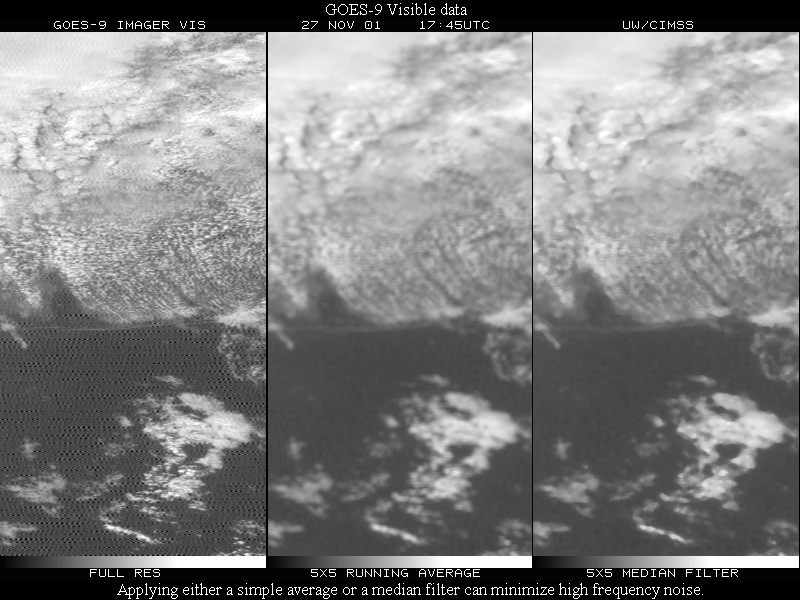
(Click for full image)
Course Taken on Good Sentence Writing: The course brochure on
good writing called out, "Are
you confusing your reader?" and "Do you sound like a bureaucrat?".
This was for me. The one-day
course, offered by the University of Madison's Division of Continuing
Studies, was held November
28, 20001. Remember, when writing a memo (or a weekly entry), 1) start
with a summary of what's
most important, 2) avoid subordinate references to other documents,
3) ensure clear organization, 4)
emphasize key ideas, and 5) avoid cliched closings. (T.
Schmit, E/RA2, 608-263-0291)
Review of TRMM VIRS Fire Product Manuscript: A manuscript titled
"A Multi-Year Active Fire Data Set for the Tropics Derived from the TRMM
VIRS" by L. Giglio et al. (Goddard Space Flight Center) was reviewed for
the International Journal of Remote Sensing. The paper provides
an overview of a 3-year fire data set derived from the Visible and Infrared
Scanner (VIRS) on board the Tropical Rainfall Measuring Mission (TRMM)
satellite. The VIRS is able to monitor fire activity in the tropics
and sub-tropics with a local overpass time that drifts over 24 hours every
month, providing snapshots of diurnal fire activity. The data set
provides a useful cross-calibration tool for other satellite fire monitoring
programs. (E. Prins,
E/RA2, 608-263-6607)
VISITORS:
NEXT WEEK:
CIMSS Board Meeting: The Cooperative Institute for Meteorological
Satellite Studies (CIMSS) will hold its annual Board meeting on Friday,
December 7. The CIMSS Board has representatives from the University
of Wisconsin, the National Oceanic and Atmospheric Administration (NOAA),
and the National Aeronautics and Space Administration (NASA). (J.
Key, E/RA2, 608-263-2605)
LOOKING AHEAD:
IN THE PRESS:
ITEMS FOR THE ADMINISTRATOR:
ITEMS FOR THE ASSISTANT ADMINISTRATOR:
ITEMS FOR THE OFFICE DIRECTOR, ORA:
Nothing to report.
ITEMS FOR THE DIVISION CHIEF, ARAD:
Comparison of GOES-12 Cloud Top Pressure Product: During the science test of the Geostationary Operational Environmental Satellite (GOES)-12, the cloud top pressure product was compared to that from other GOES instruments/satellites. In general, fair agreement was seen in the cloud top pressure products from the GOES-12 Imager, the GOES-12 Sounder, and the GOES-8 Sounder. Slight differences are due to different view angles, noise, time differences, and the lack of a split window (11 - 12 microns) on the GOES-12 Imager that aids in low-cloud detection. Of course, the GOES Imager provides a finer spatial resolution product. (T. Schreiner , CIMSS, 608-263-6754, T. Schmit, E/RA2, 608-263-0291)
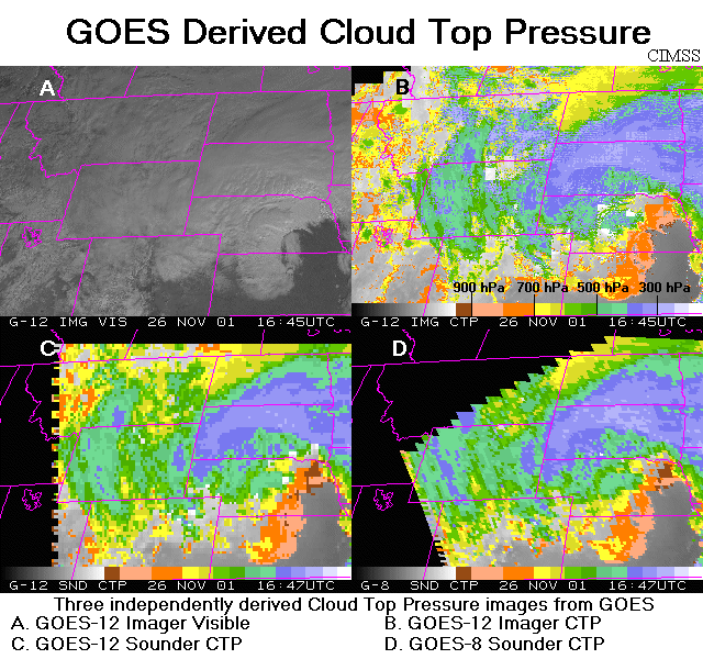
(Click for full image)
Examples of the GOES SST Diurnal Variation: By request, an example
of the diurnal variation of sea surface temperature (SST) derived
from Geostationary Operational Environmental Satellite (GOES) imager data
was prepared at the Cooperative Institute for Meteorological Satellite
Studies (CIMSS). SST variation of 3K or more was detected at a few
coastal areas. (F. Wu, CIMSS,
608-265-2113, J. Key, E/RA2, 608-263-2605)
NEXT WEEK:
LOOKING AHEAD: