[ Archive ]
| CIMSS-NOAA Weekly Report
[ Archive ] |
IN THE PRESS:
ITEMS FOR THE ADMINISTRATOR:
ITEMS FOR THE ASSISTANT ADMINISTRATOR:
ITEMS FOR THE OFFICE DIRECTOR, ORA:
ACCOMPLISHMENTS:
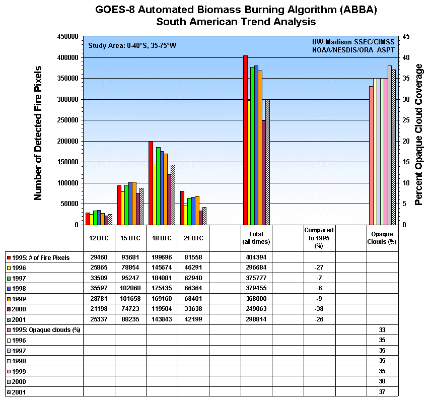
The 2001 Fire Season in South America: Geostationary Operational Environmental Satellite (GOES)-8 Automated Biomass Burning Algorithm (ABBA) fire products for June through October 2001 indicate that the amount of burning during the 2001 fire season in South America was greater than last year, but nearly 12% less than that observed on average over the past seven years. In 2001 nearly 300,000 fire pixels were detected with the GOES-8 ABBA at 11:45, 14:45, 17:45, and 20:45 UTC. These results are being used to characterize diurnal, spatial, seasonal and interannual trends in fire activity throughout South America. The study area extends from 0 to 40°S and from 35 to 75°W and includes portions of Brazil, Peru, Bolivia, Paraguay, Uruguay, and northern Argentina. (E. Prins, E/RA2, 608-263-6607, J. Feltz, CIMSS, 608-263-3434, C. Schmidt, CIMSS, 608-262-7973)
(Click on image for full view)
Figure caption: The GOES ABBA and Merged Automated Cloud/Aerosol Detection
Algorithm (MACADA) were applied to 3-hourly (11:45, 14:45, 17:45, and 20:45
UTC) multispectral data collected from June through October in each year
from 1995 to 2001. The figure provides an overview of the number
of fire pixels detected at each time period and total burning for each
year, along with the percent opaque cloud coverage. The number of fires
detected in the 2001 fire season was 26% less than observed in 1995, but
is greater than the year 2000. The opaque cloud coverage gives an indication
if the interannual variability in the number of detected fire pixels is
due to cloud coverage issues.
ITEMS FOR THE DIVISION CHIEF, ARAD:
ACCOMPLISHMENTS:
AWIPS workstation at CIMSS: The hardware for an Advanced Weather Interactive Processing System (AWIPS) workstation has been transferred from the Office of Research and Applications (ORA) in Camp Springs, Maryland to the Cooperative Institute for Meteorological Satellite Studies (CIMSS). The unit consists of the typical AWIPS workstation equipment (dual graphical monitors, unix computer, text monitor). Connectivity issues have been, and continue to be, addressed with University of Wisconsin Space Science and Engineering Center (SSEC) staff, the local National Weather Service (NWS) office in Sullivan, Wisconsin, and other AWIPS users. The capability to display and integrate data in the same environment and format that is used by the NWS will aid in the advocacy of new and established satellite products from CIMSS and the Advanced Satellite Products Team (ASPT). (T. Whittaker, CIMSS, 608-262-2759; G. Wade, E/RA2, 608-262-4743)
GOES Fire Product Applications Presented at AGU Conference: Two collaborative efforts involving applications of the Geostationary Operational Environmental Satellite (GOES) Automated Biomass Burning Algorithm (ABBA) fire products were presented at the American Geophysical Union (AGU) Fall Meeting in San Francisco. A poster titled "The Fire Locating and Modeling of Burning Emissions (FLAMBE) Project" authored by J. Reid et al. provides an overview of an interagency effort with support from the Navy, National Oceanic and Atmospheric Administration (NOAA), and the National Aeronautics and Space Administration (NASA ) to integrate remote sensing fire products into transport models in real time for monitoring and predicting burning emissions and transport. A second poster titled "Spatial and Temporal Drivers of Fire Dynamics in the Amazon/Tocantins Basin" by A. Botta, et al. (University of Wisconsin-Madison, Center for Sustainability and the Global Environment (SAGE)) examines factors and processes explaining the current spatial and temporal distribution of fires in the Amazon/Tocantins basin. (E. Prins, E/RA2, 608-263-6607, C. Schmidt, CIMSS, 608-262-7973, J. Feltz, CIMSS, 608-263-3434)
VISITORS:
NEXT WEEK:
LOOKING AHEAD:
IN THE PRESS:
ITEMS FOR THE ADMINISTRATOR:
ITEMS FOR THE ASSISTANT ADMINISTRATOR:
ITEMS FOR THE OFFICE DIRECTOR, ORA:
Evaluation of GOES-12 Instrument Noise: Researchers at the Cooperative Institute for Meteorological Satellite Studies (CIMSS) have made estimates of Geostationary Operational Environmental Satellite (GOES) -12 Imager and Sounder instrument noise. GOES-12 Imager noise values appear to be in acceptable ranges, not differing widely from previous GOES Imagers. The wider spectral response of band 3 (6.5 microns) on the GOES-12 imager compensates for the narrower field-of-view than those found on previous imagers, resulting in similar noise levels. GOES-12 Sounder noise values are within specifications on nearly all bands; these results were corroborated by D. Hillger of the Regional and Mesoscale Meteorology (RAMM) Team. For more information see http://cimss.ssec.wisc.edu/goes/g12_report/g12web.html#Noi. (M. Gunshor, CIMSS 608-263-0291, T. Schmit, E/RA2, 608-263-0291).
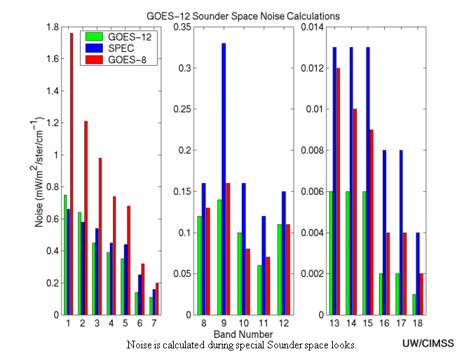
(Click image for full view)
Preparation for GWINDEX and PACJET: In anticipation of the next Pacific Jet (PACJET) west coast experiment field phase this winter (January - March, 2002), the Cooperative Institute for Meteorological Satellite Studies (CIMSS) and the National Environmental Satellite, Data, and Information Service (NESDIS) are preparing for another Geostationary Operational Environmental Satellite (GOES) rapid-scan WINds EXperiment (GWINDEX). Real-time GOES-10 winds from rapid-scan imagery at 3-hour intervals will be produced and disseminated to the National Weather Service western region forecast offices and the Forecast Systems Laboratory for Rapid Update Cycle (RUC) model assimilation. A description of this effort and a dedicated web site can be found at http://gale.ssec.wisc.edu/gwindex2. (C. Velden , CIMSS, 608-262-9168), D. Stettner, CIMSS, 608-262-8850, J. Daniels, E/RA2, 301-763-8204)
MODIS Images Show Fog/Stratus Over Snow in New England: Visible, near-InfraRed (IR), shortwave IR, and longwave IR imagery from the MODerate resolution Imaging Spectroradiometer (MODIS) instrument are used to detect small areas of fog/stratus cloud over snow cover across New England on December 10, 2001. Cloud ceilings were as low as 100 feet, and surface visibilities were less than one mile in parts of these fog/stratus features, making their accurate detection essential for aviation interests. Image examples and comparisons are available at http://cimss.ssec.wisc.edu/goes/misc/modis/water_vs_ice/011210.html. (S. Bachmeier , CIMSS, 608-263-3958)
ITEMS FOR THE DIVISION CHIEF, ARAD:
GOES-12 Images Provided to Meteo-France: The Data Center at the University of Wisconsin Space Science and Engineering Center sent raw image files of seven Geostationary Operational Environmental Satellite (GOES) -12 images to Jean-Francois Aurejac of Meteo-France (Lannion, France) to aid in the development their GOES-12 ingestor. The data were provided on request by B. Hickman of the National Environmental Satellite, Data, and Information Service (NESDIS). (D. Wade, CIMSS, 608-263-0527)
FAA Weather Research Program Review: Tom Achtor, Cooperative Institute for Meteorological Satellite Studies (CIMSS), attended the Federal Aviation Agency (FAA) Aviation Weather Research Program (AWRP) annual review in Boulder, Colorado on December 5. CIMSS is interested in seeking ways to improve aviation weather products and nowcasts through the use of data from the Geostationary Operational Environmental Satellite (GOES), Polar-orbiting Operational Environmental Satellite (POES), MODerate resolution Imaging Spectrometer (MODIS), and eventually the Geostationary Imaging Fourier Transform Spectrometer (GIFTS) systems. CIMSS is seeking to partner with the National Aeronautics and Space Administration (NASA) Langley Aviation Safety Division in a proposal effort to NASA and the FAA to develop meteorological weather satellite products and applications for the aviation community. The National Oceanic and Atmospheric Administration (NOAA) Aviation Weather Center (AWC) was represented at the AWRP meeting and Fred Mosher, AWC, has been contacted regarding this project. (T. Achtor , CIMSS, 608-263-4206)
Ground System Proposals Presented to NESDIS/ORA: On December 10, 2001 scientists at the Cooperative Institute for Meteorological Satellite Studies (CIMSS) presented proposals to F. Holt of the Office of Research and Applications, National Environmental Satellite, Data, and Information Service (NESDIS) for support from the Office of Systems Development (OSD) Ground Systems project. The presentations covered research for satellite intercalibration, cloud top pressure, winds, convective rain, radiative transfer, sea surface temperature, and volcanic ash remote sensing. (M. Gunshor , CIMSS, 608-263-1146, T. Schreiner , CIMSS, 608-263-6754, X. Wu , CIMSS, 608-265-2113, C. Velden , CIMSS, 608-262-9168, S. Ackerman , CIMSS, 608-263-3647)
NEXT WEEK:
LOOKING AHEAD: