[ Archive ]
| CIMSS-NOAA Weekly Report
[ Archive ] |
IN THE PRESS:
ITEMS FOR THE ADMINISTRATOR:
ITEMS FOR THE ASSISTANT ADMINISTRATOR:
ITEMS FOR THE OFFICE DIRECTOR, ORA:
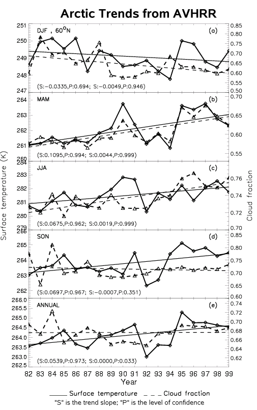
Arctic Trends from Space: Trends in Arctic surface
temperature, surface albedo, cloud amount, cloud particle phase, and cloud
particle size have been observed in 18 years of Advanced Very High Resolution
Radiometer (AVHRR) data. An overall increase in surface temperature on an
annual scale agrees with warming trends reported in the literature, but the
satellite data show that the temperature trends are of opposite sign in different
seasons, decreasing in the winter months and increasing at other times of
the year. The AVHRR data also illustrate a decrease in cloud amount
in winter but an increase in spring and summer, cancelling each other
on an annual time scale. The seasonal trends in surface temperature,
surface albedo, and cloud amount do not give rise to trends in the surface
net cloud radiative effect nor in the surface net radiation flux. It appears
that the decrease in sea ice extent and albedo that results from surface
warming modulates the cooling effect of increasing cloud amount, resulting
in little or no change in the surface radiation budget. (J. Key, E/RA2, 608-263-2605, X.
Wang, CIMSS, 608-262-2828)
(Click on image to enlarge)
Figure caption: Trends in surface temperature (solid, left scale) and cloud
amount (dashed, right scale) over the Arctic north of 60 degrees latitude
for winter, spring, summer, fall, and annually (top to bottom). The
straight lines are statistical trend lines (degrees Kelvin per year and cloud
fraction per year), with their slopes and levels of confidence indicated
on each plot, the left pair for surface temperature and the right for cloud
amount.
Moisture and Cloud Assimilation Using MODIS:
Retrievals of total precipitable water and cloud-top pressure from the MODerate
resolution Imaging Spectroradiometer (MODIS) are being evaluated in the polar
version of the Cooperative Institute for Meteorological Satellite Studies
(CIMSS) Regional Assimilation System (PCRAS) over Antarctica. The data are
being used to adjust mixing ratio and cloud water in the forecast model during
a 24 hour forecast initialization period. Approximately 800,000 observations
at 5 km resolution are available from each satellite pass over the south pole.
Difference fields of total precipitable water (with and without MODIS) at
the end of the 24 hour initialization period indicate that the MODIS data
tends to dry the forecast model and reduce cloudiness in the coastal regions
surrounding Antarctica. (R. Aune,
E/24, 608-262-1071)
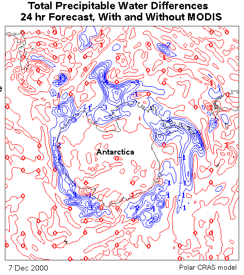
(Click image to enlarge)
Figure caption: The effect of assimilating MODIS total precipitable water
(TPW) on the moisture field around Antarctica, as simulated with the polar
version of the CIMSS Regional Assimilation System (PCRAS). Differences
in TPW are shown (with MODIS minus without MODIS) at the end of the 24-hr
initialization period on December 7, 2000. The MODIS data has reduced
the amount of water vapor in the coastal regions (blue areas).
Press Coverage of Geostationary Satellite Fire Monitoring: The satellite biomass burning monitoring team at the Cooperative Institute for Meteorological Satellite Studies (CIMSS) participated in numerous radio, television, and newspaper interviews over the past two weeks associated with press releases by the National Oceanic and Atmospheric Administration (NOAA) and the University of Wisconsin-Madison regarding Geostationary Operational Environmental Satellite (GOES) Wildfire Automated Biomass Burning Algorithm (WF_ABBA) fire detection and monitoring in the Western Hemisphere. Most of the stories focused on applications of the GOES WF_ABBA in monitoring the Colorado and Arizona wildfires. SPACE.COM published a very balanced article that also appeared on MSNBC.COM. Discoveries & Breakthroughs Inside Science (DBIS), a television science news service, did an in-depth video interview, which will be released to media markets around the country. (E. Prins,, E/RA2, 608-263-6607, C. Schmidt, CIMSS, 608-262-7973, J. Feltz, CIMSS, 608-263-3434)
ITEMS FOR THE DIVISION CHIEF, ARAD:
GOES Sounder Displays Available for CRYSTAL:
Following completion of the field campaign for the International H2O Project
(IHOP) over the Oklahoma Panhandle region, the focus for higher resolution
displays of Geostationary Operational Environmental Satellite (GOES) Sounder
products has shifted to the southern Florida region. The emphasis here is
to provide the sounder data, including moisture (precipitable water), stability
(lifted index), and cloud information (cloud top pressure), in support of
a cirrus cloud study. S. Ackerman of the Cooperative Institute for Meteorological
Satellite Studies (CIMSS) is a principal contributor to the Cirrus Regional
Study of Tropical Anvils and Cirrus Layers - Florida Area Cirrus Experiment
(CRYSTAL-FACE) and will be the key on-site advocate for this satellite data.
The real-time and archived GOES Sounder displays for CRYSTAL are available
at http://cimss.ssec.wisc.edu/goes/realtime/face/.
(G. Wade, E/RA2, 608-263-4743)
Reunion of Meteorology Alumni at Penn State:
A reunion was held at the Department of Meteorology, The Pennsylvania State
University on June 21-22 to celebrate the 30th anniversary of the Campus Weather
Service, a student organization comprised of 150 volunteer student forecasters
who provide forecasting services to the media. On Saturday morning a panel
discussion on "The Future of the Meteorology Department" was led by Dr. W.
Brune, department chairman, and Dean J. Dutton, Dean of the College of Earth
and Mineral Science, who focussed on the skills that future meteorology students
will require. Dean Dutton mentioned the need for students to master the
fundamentals used in the atmospheric sciences and to be ready to handle the
five order of magnitude increase in data coming primarily from satellites.
A second panel discussion, "Are There Still Jobs for Weather Weenies", was
led by representatives of the media, the military, and by BG (Ret.) John G.
W. Kelley, who summarized the needs of the Weather Service of the future.
(R. Aune, E/24, 608-262-1071)
Extended Abstract for SPIE Conference: An extended abstract titled "The Arctic Climate and Its Change Revealed by Surface and Cloud Properties and Radiation Fluxes Based on the AVHRR Polar Pathfinder Data Set", by X. Wang (Cooperative Institute for Meteorological Satellite Studies (CIMSS)) and J. Key was submitted for the SPIE International Symposium on Optical Science and Technology to be held in Seattle, Washington, July 7-11. (J. Key, E/RA2, 608-263-2605, X. Wang, CIMSS, 608-262-2828)
VISITORS:
TMC Technologies: T. Schmit gave a demonstration on various Cooperative Institute for Meteorological Satellite Studies (CIMSS) products, the Advanced Baseline Imager (ABI), and the Advanced Baseline Sounder (ABS) to visitors from TMC Technologies. TMC Technologies has a project funded by the National Climatic Data Center (NCDC) to improve access to large datasets such as GOES data. They visited CIMSS to learn more about GOES data access needs. (T. Schmit, E/RA2, 608-263-0291)
NEXT WEEK:
LOOKING AHEAD:
IN THE PRESS:
ITEMS FOR THE ADMINISTRATOR:
ITEMS FOR THE ASSISTANT ADMINISTRATOR:
ITEMS FOR THE OFFICE DIRECTOR, ORA:
ITEMS FOR THE DIVISION CHIEF, ARAD:
MODIS image of the Arizona fires Provides A Glimpse
of Future ABI Capabilities: A composite MODIS image shows the Arizona
fires and what would be possible from the Advanced Baseline Imager (ABI
), but with increased temporal resolution. The 3-channel composite image
using 500-meter resolution National Aeronautics and Space Administration
(NASA) Terra MODerate-resolution Imaging Spectroradiometer (MODIS) data
reveals two very large burn scars, with active fire hot spots around the
periphery of the burn scars, and thick smoke drifting northeastward. These
2 large fires (Rodeo and Chediski) exhibited extreme behavior due to high
winds on June 23, 2002, and began to merge to the west of Show Low in southern
Navajo county (http://cimss.ssec.wisc.edu/goes/misc/020623/020623.html).
The rapid intensification of the Rodeo/Chediski complex on June 20, 2002
was one of the most extreme examples ever documented with the Geostationary
Operational Environmental Satellite (GOES) Wildfire Automated Biomass Burning
Algorithm (WF_ABBA) as shown in this animation (http://cimss.ssec.wisc.edu/goes/burn/2002171/20020620_g08_WF_ABBA_rt66nmex_anim.html).
(S. Bachmeier, CIMSS,
608-263-3958, C. Schmidt, CIMSS, 608-262-7923, T. Schmit, E/RA2, 608-263-0291,
E. Prins, E/RA2, 608-263-6607).
Summary Report on the PIFTS Breadboard Instrument: L. Sromovsky provided an update of his work with the Planetary Imaging Fourier Transform Spectrometer (FTS) (PIFTS). The PIFTS breadboard provides an opportunity to gain experience with real imaging FTS data that can help to evaluate instrument design trades, calibration procedures, and data handling algorithms that may be needed in future systems. This report included a number of highlights, one of which was the clear-sky intercomparison with the Atmospheric Emitted Radiance Interferometer (AERI). Excellent radiance agreement between a imaging FTS (PIFTS) and a single detector FTS (AERI) was shown. (L. Sromovsky, SSEC, 608 263-6785)
VISITORS:
NEXT WEEK:
LOOKING AHEAD: