[ Archive ]
| CIMSS-NOAA Weekly Report
[ Archive ] |
IN THE PRESS:
ITEMS FOR THE ADMINISTRATOR:
ITEMS FOR THE ASSISTANT ADMINISTRATOR:
ITEMS FOR THE OFFICE DIRECTOR, ORA:
Potential Midlatitude Forecast Errors Without MODIS Polar Winds: Niels Bormann of the European Centre for Medium-Range Weather Forecasts (ECMWF) provided a case study that showed how errors in forecasts can propogate from the Arctic to the midlatitudes when the Moderate Resolution Imaging Spectroradiometer (MODIS) polar winds data are not used in the initial analysis. In the experiment, an area of large differences in the 500 hPa geopotential height between forecasts with and without MODIS winds propagated from the Beaufort Sea north of Alaska to the Gulf of Alaska and the north Pacific Ocean over a 5-day period. The implication of this study is that better observations over the poles can improve forecasts in the midlatitudes. (J. Key, E/RA2, 608-263-2605, D. Santek, CIMSS, 608-263-7410, C. Velden , CIMSS, 608-262-9168)
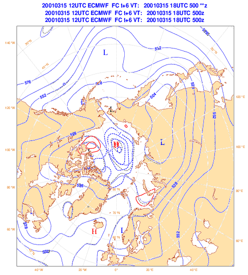
Figure caption: This animation shows the propagation of analysis errors
from the poles to the midlatitudes for one case study. Each frame
shows the 500 hPa geopotential height for forecasts from 1 to 5 days in
1 day increments. The solid blue line is the geopotential from
the experiment that included MODIS winds; the dashed black line is
the control (CTL) experiment without MODIS winds. Solid red lines
show positive differences in the geopotential height (MODIS minus CTL),
and thick dashed blue lines show negative differences. The area of large
positive differences near the Beaufort Sea north of Alaska moves southward
over the 5-day period. The CTL run is forming a deeper trough than
the MODIS run over central Alaska and then over the Pacific Ocean south
of Alaska .
ITEMS FOR THE DIVISION CHIEF, ARAD:
Updated HES/ABS Technical Requirements Document: The Advanced Baseline Sounder (ABS), now called the Hyperspectral Environmental Sensor (HES), Technical Requirements Document (TRD) has been updated. The update was necessary to fill-in requirements missing in the original ABS TRD; modify existing requirements, where possible, to simplify the design, and to update the document to emphasize that the HES is instrument design "neutral". Some of the changes include: instrument noise, co-registration between bands, two spectral wavebands, pixel operability, data rates and instrument design "neutral". The members of the update group were from Massachusetts Institute of Technology/Lincoln Lab (MIT/LL), National Oceanic and Atmospheric Administration/National Environmental Satellite, Data, and Information Service (NOAA/NEDSIS), National Aeronautics and Space Administration (NASA), and some NASA contractors. (T. Schmit, E/RA2, 608-263-0291)
GOES Abstracts submitted for the 12th annual AMS satellite conference: The following abstracts involving the Geostationary Operational Environmental Satellite (GOES) were submitted for the 12th annual American Meteorological Society (AMS) satellite conference: "Introducing the Geostationary Operational Environmental Satellite (GOES) Imager Clear-Sky Brightness Temperature (CSBT) Product", "Channel selection for the next generation geostationary Advanced Baseline Imagers", "GOES-11 and GOES-8 Sounders During the International H2O Project (IHOP)-2002 Field Experiment", "Surface and Atmospheric Retrievals from the Future GOES Sounder - Advanced Baseline Sounder (ABS)" and "Vegetation Monitoring and Thin Cirrus Detection on the Next Generation GOES Imager". Each has a number of authors from National Oceanic and Atmospheric Administration/National Environmental Satellite, Data, and Information Service (NOAA/NESDIS) and the Cooperative Institute for Meteorological Satellite Studies (CIMSS). One paper is authored by an undergraduate student. (T. Schmit, E/RA2, 608-263-0291)
VISITORS:
NEXT WEEK:
LOOKING AHEAD:
IN THE PRESS:
ITEMS FOR THE ADMINISTRATOR:
ITEMS FOR THE ASSISTANT ADMINISTRATOR:
ITEMS FOR THE OFFICE DIRECTOR, ORA:
Shortwave IR Winds Code Transition Complete:
The code for 3.9 micron shortwave infrared (SWIR) winds at night has been
transitioned from the Cooperative Institute for Meteorological Satellite
Studies (CIMSS) to the National Environmental Satellite, Data, and Information
Service's (NESDIS) Forecast Products Development Team (FPDT). FPDT
is now running and testing real time SWIR winds from both Geostationary
Operational Environmental Satellites (GOES). The addition of the SWIR winds
increases the number of low-level winds significantly. (C. Velden , CIMSS, 608-262-9168)
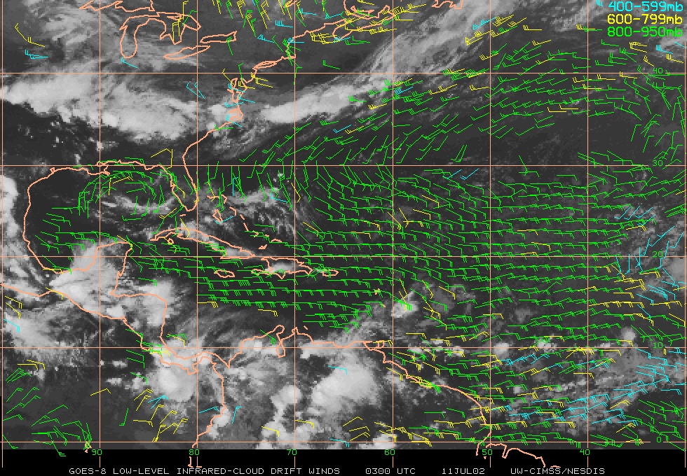
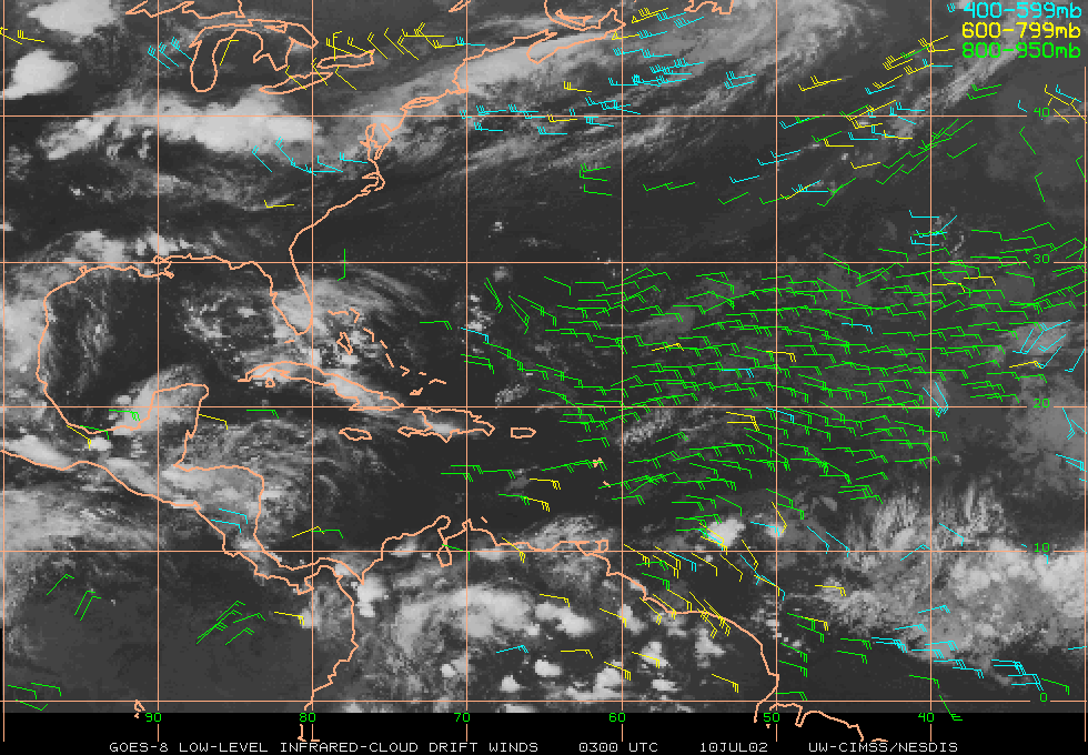
(Click images to enlarge)
Figure caption: GOES winds with (top) and without (bottom) the use of the
shortwave infrared (SWIR) 3.9 micron band. Note the increase in the
number of low-level wind vectors when the SWIR band is used.
ITEMS FOR THE DIVISION CHIEF, ARAD:
GOES and MODIS Monitor Smoke from Canadian Wildfires:
Geostationary Operational Environmental Satellite (GOES-8) and Moderate Resolution
Imaging Spectroradiometer (MODIS) data revealed the location of wildfires
in Canada, and the subsequent transport of thick smoke across parts of the
eastern United States during the June 21 - July 08, 2002 period. A great
deal of diurnal variation was noted in the experimental GOES Wildfire Automated
Biomass Burning Algorithm (WFABBA) product as the fires intensified across
Quebec on July 5-6. Image examples and animations are available in the Cooperative
Institute for Meteorological Satellite Studies (CIMSS) GOES Gallery:
http://cimss.ssec.wisc.edu/goes/misc/020628/020628.html.
(S. Bachmeier , CIMSS,
608-263-3958, E. Prins,
E/RA2, 608-263-6607, C. Schmidt,
CIMSS, 608-262-7973)
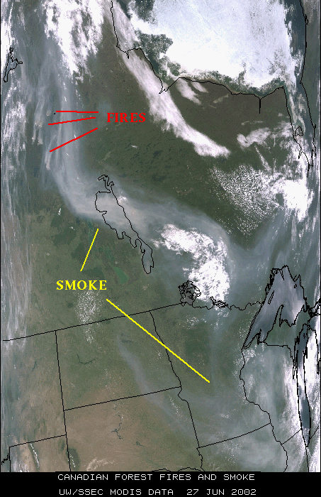
(Click image to enlarge)
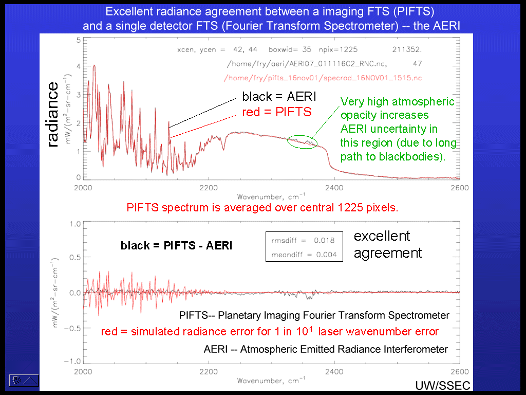
PIFTS Breadboard Instrument Comparison with AERI:
L. Sromovsky has worked with the Planetary Imaging Fourier Transform Spectrometer
(FTS) (PIFTS) to gain experience with real imaging FTS data that can help
to evaluate instrument design trades, calibration procedures, and data handling
algorithms for future systems. A clear-sky intercomparison with Atmospheric
Emitted Radiance Interferometer (AERI) has shown excellent radiance agreement
between a imaging FTS (PIFTS) and a single detector FTS (AERI) (L. Sromovsky,
SSEC, 608-263-6785)
Joint Hurricane Testbed (JHT) Progress: Chris Velden and Tim Olander of the Cooperative Institute for Meteorological Satellite Studies (CIMSS) traveled to the National Hurricane Center (NHC) to provide seminars and training on satellite modules being transitioned into NHC operations as part of the U.S. Weather Research Program (USWRP) JHT program. The two primary modules are the Advanced Microwave Sounding Unit (AMSU) hurricane intensity estimation algorithm and the Advanced Objective Dvorak Technique (AODT). Both methods are showing promise to the hurricane forecasters and will be tested in real time this coming hurricane season. (C. Velden , CIMSS, 608-262-9168)
VISITORS:
NEXT WEEK:
LOOKING AHEAD: