[ Archive ]
| CIMSS-NOAA Weekly Report
[ Archive ] |
IN THE PRESS:
ITEMS FOR THE ADMINISTRATOR:
ITEMS FOR THE ASSISTANT ADMINISTRATOR:
ITEMS FOR THE OFFICE DIRECTOR, ORA:
New Algorithm for the Retrieval Temperature Inversions with MODIS: A method for estimating the strength and height of low-level atmospheric temperature inversions with the Moderate Resolution Imaging Spectroradiometer (MODIS) has been developed. Empirical equations were formulated to quantify the relationship between temperature inversion strength (temperature difference across the inversion), inversion height, and various combinations of MODIS infrared band brightness temperatures, particularly the 7.2 µm water vapor band. An application of the method to collocated MODIS and radiosonde data in both polar regions shows that temperature inversion strength can be estimated with accuracies of 2-3 degrees overall, while inversion height has root-mean-square errors on the order of 250 meters. The temperature inversion strength from the National Centers for Environmental Prediction (NCEP)/National Center for Atmospheric Research (NCAR) Reanalysis product is usually smaller than the actual inversion strength and that estimated directly from MODIS, and the mean error is significantly larger. (J. Key, E/RA2, 608-263-2605)
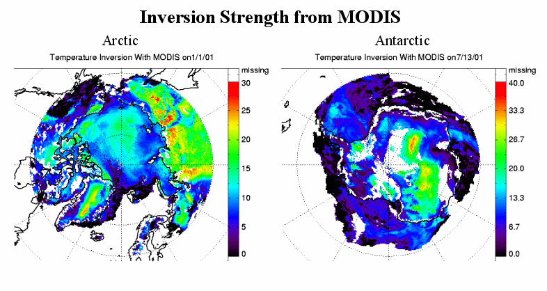
(Click on image to enlarge)
Figure caption: Low-level atmospheric temperature inversion strength
(temperature difference across the inversion) in degrees Centigrade over
the Arctic (left) and Antarctic (right) for one winter day estimated from
MODIS.
ITEMS FOR THE DIVISION CHIEF, ARAD:
Nothing to report.
VISITORS:
Jung and Daniels Visit CIMSS: Jim Jung (Cooperative Institute for Meteorological Satellite Studies (CIMSS) working in Camp Springs) and Jaime Daniels (Office of Research and Applications/Forecast Products Development Team) visited CIMSS on August 19-20. Topics discussed included the wind assimilation, wind generation issues, the cloud-top product, and Geostationary Operational Environmental Satellite (GOES) imager radiance assimilations. (T. Schmit, E/RA2, 608-263-0291)
NEXT WEEK:
CIMSS Science Council Meeting: The Cooperative Institute for Meteorological Satellite Studies (CIMSS) Science Council will meet on Tuesday, August 27. (J. Key, E/RA2, 608-263-2605)
LOOKING AHEAD:
IN THE PRESS:
ITEMS FOR THE ADMINISTRATOR:
ITEMS FOR THE ASSISTANT ADMINISTRATOR:
ITEMS FOR THE OFFICE DIRECTOR, ORA:
ITEMS FOR THE DIVISION CHIEF, ARAD:
Initial AIRS Intercalibration with GOES-10 Imager: The Atmospheric InfraRed Sounder (AIRS) is a high spectral resolution, polar-orbiting sounder which was launched in May 2002 by the National Aeronautics and Space Administration (NASA) as part of their Earth Observing System (EOS) on Aqua. Researchers at the Cooperative Institute for Meteorological Satellite Studies (CIMSS) have calculated initial intercalibration results with AIRS and the Geostationary Operational Environmental Satellite (GOES) -10 Imager by convolving the AIRS data with GOES-10 spectral response functions and comparing mean brightness temperatures for an area near the GOES-10 sub-satellite point (135 West). In two preliminary test cases, the brightness temperature difference between AIRS and GOES in bands 2 (3.9 micron), 4 (11 micron), and 5 (12 micron) was small (less than 0.3K); comparison in the water vapor channel (band 3) is difficult because AIRS does not cover the entire water vapor spectrum and thus there are errors associated with convolving the data with the GOES spectral response function. (M. Gunshor, CIMSS, 608-263-1146, D. Tobin, CIMSS, 608-265-6281).
VISITORS:
NEXT WEEK:
LOOKING AHEAD: