[ Archive ]
| CIMSS-NOAA Weekly Report
[ Archive ] |
IN THE PRESS:
ITEMS FOR THE ADMINISTRATOR:
ITEMS FOR THE ASSISTANT ADMINISTRATOR:
ITEMS FOR THE OFFICE DIRECTOR, ORA:
SPoRT Meeting: T. Schmit attended the National Aeronautics and Space Administration's (NASA) first Short-term Prediction Research and Transition Center (SPoRT) Science Advisory Committee (SAC) Meeting. The SPoRT is co-located with the new National Weather Service Forecast Office (HUN). The meeting was November 13-14 in Huntsville, AL. T. Schmit attended as a representative of W. P. Menzel. For more information on SPoRT see http://wwwghcc.msfc.nasa.gov/sport. (T. Schmit, E/RA2, 608-263-0291)
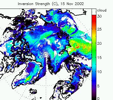
Real-time Temperature Inversions from MODIS: Temperature inversion characteristics in the polar regions are now retrieved in near real-time with the Moderate Resolution Imaging Spectroradiometer (MODIS). The strength (temperature difference across the inversion) and height of low-level, clear sky atmospheric temperature inversions are estimated with MODIS water vapor and infrared window channels. Daily composites are available on the Web at http://stratus.ssec.wisc.edu/products/rtinversions. Other real-time polar products are available at http://stratus.ssec.wisc.edu/products/realtime.html. (J. Key, E/RA2, 608-263-2605, Y. Liu, CIMSS, 608-265-8620)
Multi-sensor Active Fire and Burn Scar Detection Collaboration: The Advanced Satellite Products Team (ASPT) and the Cooperative Institute for Meteorological Satellite Studies (CIMSS) are collaborating with J. Pereira of the Instituto Superior de Agronomia at the Universidad Tecnica de Lisboa in Lisbon, Portugal on multi-sensor active fire and burn scar detection comparisons. Preliminary burned area mapping results based on SPOT-4 (Satellite Pour l'Observation de la Terre) vegetation data at 1 km spatial resolution appear to indicate that there are regions in Brazil where burn scars are hard to capture at 1 km resolution. In those situations, active fires detected with the Geostationary Operational Environmental Satellite (GOES) Wildfire Automated Biomass Burning Algorithm (WF_ABBA) are needed to complement burned area maps. SPOT derived burn scar maps are also being compared with higher resolution Landsat scenes. This study is providing valuable insight on the utility of combining multi-sensor active fire and burn scar products to correctly characterize fire regimes in South America. (E. Prins, E/RA2, 530-271-2256, J. Feltz, E/RA2, 608-263-3434)
ITEMS FOR THE DIVISION CHIEF, ARAD:
Improvement to NCEP
Data Acquisition: A new computer program was written that will catch
a hanging semaphore (a file signaling a certain condition) in the National
Centers for Environmental Prediction (NCEP) data acquisition process at the
Cooperative Institute for Meteorological Satellite Studies (CIMSS). The use
of a semaphore prevents concurrent running of multiple processes, but can
be problematic if the computer crashes. Before using this program, human
monitoring was required. At CIMSS, NCEP data is used in the generation of
many satellite-derived products as well as for numerical weather forecast
model initialization. (G. Callan,
E/RA2, 608-2633951)
ICAPOP Meeting Input:
T. Schmit provided information for the November Image/Cloud/Aerosol Product
Oversight Panel (ICAPOP) meeting. This was a update on the status of the
Geostationary Operational Environmental Satellite (GOES) Clear-Sky Brightness
Temperatures (CSBT) processing. The presentation will be either given by C.
Holland or J. Jung. (T. Schmit, E/RA2, 608-263-0291)
Ground Systems Proposal Presentations: Seven proposals from the Cooperative Institute for Meteorological Satellite Studies (CIMSS) and the Advanced Satellite Products Team (ASPT) were presented for support from the Office of Systems Development/Office of Research and Applications Ground Systems project. The presentations were made via video teleconference by A. Heidinger (ASPT), T. Schmit (ASPT), C. Velden (CIMSS), M. Gunshor (CIMSS), W. Feltz (CIMSS), M. Lazzara (CIMSS). This set of proposals were for products from the Geostationary Operational Environmental Satellite (GOES). (J. Key, E/RA2, 608-263-2605)
VISITORS:
NEXT WEEK:
LOOKING AHEAD:
IN THE PRESS:
ITEMS FOR THE ADMINISTRATOR:
ITEMS FOR THE ASSISTANT ADMINISTRATOR:
ITEMS FOR THE OFFICE DIRECTOR, ORA:
IST/VISIT Training Meeting in Madison: On November 8th, the Cooperative Institute for Meteorological Satellite Studies (CIMSS) hosted the annual Integrated Sensor Training/Virtual Institute for Satellite Integration Training (IST/VISIT) meeting on the University of Wisconsin-Madison campus. Attendees included Tom Whittaker (CIMSS), Scott Bachmeier (CIMSS), Scott Lindstrom (Space Science and Engineering Center (SSEC)), Tony Mostek (Cooperative Program for Operational Meteorology, Education and Training (COMET)), Dan Bikos and Dan Lindsey (Cooperative Insititude for Reasearch in the Atmosphere (CIRA)), John Eise (Science Operations Officer (SOO) of the National Weather Service (NWS) office in Sullivan, Wisconsin), and Dan Baumgardt (SOO at the NWS office in La Crosse, Wisconsin). Brad Grand (Warning Decision Training Branch (WDTB) of the NWS) attended virtually. Joining the group for the first portion of the meeting was Elliott Jacks (Office of Climate, Water and Weather Services Training Division) and Mike Dion (NWS Training Division, Learning Management System (LMS)). Briefings were also provided by Patrick Dills and Woody Wang (COMET), Tim Schmit , and Gary Wade. (T. Whittaker, CIMSS, 608-262-2759)
ITEMS FOR THE DIVISION CHIEF, ARAD:
VISITORS:
NEXT WEEK:
LOOKING AHEAD: