[ Archive ]
| CIMSS-NOAA Weekly Report
[ Archive ] |
IN THE PRESS:
ITEMS FOR THE ADMINISTRATOR:
ITEMS FOR THE ASSISTANT ADMINISTRATOR:
GOES Imager CSBT Product in ECMWF Operational System: As of January 14, 2003, the European Centre for Medium-range Weather Forecasts (ECMWF) is assimilating Geostationary Operational Environmental Satellite (GOES) imager data in their operational system. The GOES Clear Sky Brightness Temperature (CSBT) product is based on band 3 (6.7 µm) data of the Imager, screened for clouds and averaged at the Cooperative Institute for Meteorological Satellite Studies (CIMSS). ECMWF is using hourly GOES data over oceanic regions. Parallel runs have shown positive impact when these radiances are included. The National Centers for Environmental Prediction (NCEP) is also evaluating these data, while efforts continue to have this product generated by National Environmental Satellite, Data, and Information Service (NESDIS) Operations. (T. Schmit, E/RA2, 608-263-0291, T. Schreiner , CIMSS, 608-263-6754, G. Callan, E/RA2, 608-263-3951)
ITEMS FOR THE OFFICE DIRECTOR, ORA:
Parallel
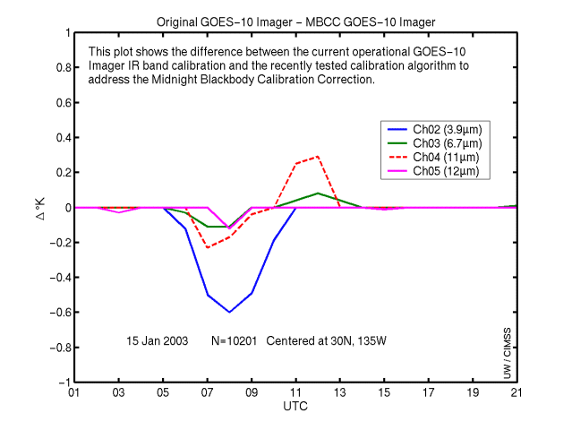
Calibration of GOES-10 Imager: Parallel data from the
Geostationary Operational Environmental Satellite (GOES)-10 imager were
sent via GOES-12 from 13 January to 16 January, 2003 to assess a new
calibration procedure that corrects for the known midnight calibration
error. It was confirmed that the 3.9 µm imager band was the most
affected (by 0.5K on average) between 07 and 09 Universal Coordinated
Time (UTC). A powerpoint presentation was prepared with preliminary
brightness temperature time series and scatter plots. A completely
parallel GOES-10 Clear-Sky Brightness Temperature (CSBT) product was
also produced each hour and made available to global modelers for
testing. This unique GOES VARiable (GVAR) data stream was also
archived. (T. Schmit,
E/RA2, 608-263-0291, T.
Schreiner , CIMSS, 608-263-6754, M.
Gunshor, CIMSS, 608-263-1146, D. Wade, CIMSS, 608-263-0527)
ITEMS FOR THE DIVISION CHIEF, ARAD:
CLAVR Status
Meeting Convened: A meeting was held on January 7, 2003 in
Suitland, Maryland between Office of Research and Applications (ORA) and
Office of Satellite Data Processing and Distribution (OSDPD) personnel
involved in the Clouds from AVHRR (CLAVR) project. Topics discussed
included the need for improved geolocation algorithms in CLAVR for high
resolution surface applications and the possible generation of a high
resolution (1-4 km) sea surface temperature (SST) product from CLAVR.
The current SST product has a resolution of roughly 8 km. (A. Heidinger, E/RA2,
608-263-6757)
Paper Reviewed
for JGR-Atmospheres: A. Heidinger reviewed a manuscript for the Journal of Geophysical Research
(JGR). The manuscript was titled "Retrieving Cloud Information from
Passive Measurements of Solar Radiation Absorbed by Molecular Oxygen
and O2-O2". (A. Heidinger,
E/RA2, 608-608-6757)
LOOKING AHEAD:
IN THE PRESS:
ITEMS FOR THE ADMINISTRATOR:
ITEMS FOR THE ASSISTANT ADMINISTRATOR:
MODIS Polar Winds in ECMWF Operational System: The real-time polar winds product derived from the Moderate Resolution Imaging Spectroradiometer (MODIS) became part of the European Centre for Medium-Range Weather Forecasts (ECMWF) operational weather forecasting system on January 14, 2003. For the past few months the MODIS winds have been tested in the "E-suite", the last pre-operational test of model, analysis, and data changes. Jean-Noël Thépaut of ECMWF stated that the 3D-Var (three-dimensional variational analysis) tests showed a dramatic improvement when the polar winds were assimilated. The 4D-Var tests showed a smaller, but still globally positive, impact. He summarized the results by saying "the MODIS winds experience can be considered as a great success". (C. Velden, CIMSS, 608-262-9168, D. Santek, CIMSS, 608-263-7410, J. Key, E/RA2, 608-263-2605, P. Menzel, E/RA2, 608-263-4930)
ITEMS FOR THE OFFICE DIRECTOR, ORA:
ITEMS FOR THE DIVISION CHIEF, ARAD:
New version Satellite Winds Code Released: Major advances in version 3.00 of the software to retrieve winds from satellite data include the addition of the Geostationary Operational Environmental Satellite (GOES)- 9 and GOES-12, and MODIS winds processing capability. This upgrade complements the current geostationary satellite winds production code in place at the National Environmental Satellite, Data, and Information Service (NESDIS) and makes inroads into the realm of polar-orbiting satellites for the generation of winds over polar regions. Version 3.00 is also the first PC-compatible winds code from the Cooperative Institute for Meteorological Satellite Studies (CIMSS), providing functionality for Linux users. Other improvements/additions include upgrades for CO2 slicing height assignments, middle-image targeting, implementation of the PLOD transmittance model for GOES, and added efficiencies to decrease run time. (G. Dengel, CIMSS, 608-265-2322)
VISITORS:
NEXT WEEK:
LOOKING AHEAD: