[ Archive ]
| CIMSS-NOAA Weekly Report
[ Archive ] |
IN THE PRESS:
ITEMS FOR THE ADMINISTRATOR:
ITEMS FOR THE ASSISTANT ADMINISTRATOR:
ITEMS FOR THE OFFICE DIRECTOR, ORA:
ITEMS FOR THE DIVISION CHIEF, ARAD:
Turbulence
Signature in GOES and MODIS Water Vapor Imagery: Water vapor
channel imagery from two Geostationary Operational Environmental
Satellites (GOES-12 and GOES-8) and the Moderate Resolution Imaging
Spectroradiometer (MODIS) revealed mountain waves that were responsible
for several pilot reports of moderate to severe turbulence over the
mid-Atlantic states on February 4, 2003. Water vapor brightness
temperatures were about 1.4 K warmer on GOES-12 compared to GOES-8, due
in part to the spectrally wider water vapor channel on GOES-12. The
improved spatial resolution (4 kilometer) of the GOES-12 water vapor
channel also allowed for better detection of the mountain waves, though
not to the degree possible using 1 kilometer resolution MODIS water
vapor data. Image examples and animations are available on the
Cooperative Institute for Meteorological Satellite Studies (CIMSS) GOES
Gallery (http://cimss.ssec.wisc.edu/goes/misc/030204/030204.html).
(S. Bachmeier,
CIMSS, 608-263-3958, M. Gunshor, CIMSS)
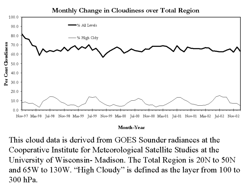
Compilation of Multi-year Cloud Information
from GOES Sounder. Since November 1997 cloud information, including
average cloud top pressure, effective cloud amount, and average clear
and cloudy brightness temperatures based on radiances from the
Geostationary Operational Environmental Satellite (GOES) Sounder have
been compiled and archived. The first 26 month period of these data was
been used in the journal paper "Observations and trends of clouds based
on GOES sounder" (J. Geophys. Res.,
106, 2001). It is now possible to look at inter annual diurnal trends
of cloud properties based on the GOES Sounder radiances with the five
year data set. (T.
Schreiner , CIMSS, 608-263-6754)
(Click on image to enlarge)
GOES Sounder DPI
Improved for IHOP: Derived Product Images (DPI) from the
Geostationary Operational Environmental Satellite (GOES) Sounder, made
at the Cooperative Institute for Meteorological Satellite Studies
(CIMSS), were found to be suboptimal during periods of the
International H2O Project (IHOP) in the spring of 2002, with anomalous
losses of coverage in seemingly clear regions due to retrieval
failures. Recent experimentation with noise thresholds in the
retrieval algorithm showed markedly improved spatial coverage for the
case of June 12, 2002. Correction was also required to the ancillary
surface observation data for a few hours on that day. The improved DPI
have been included in a poster for presentation at the February 2003
American Meteorological Society (AMS) Annual Meeting. (G. Wade, E/RA2, 608-263-4743)
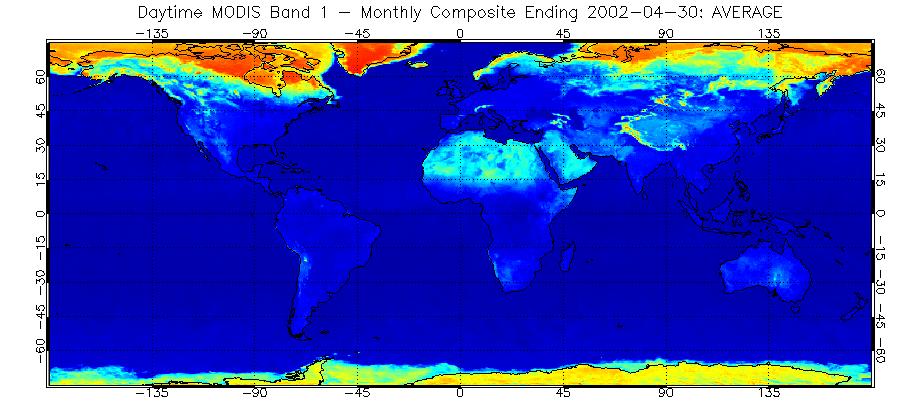
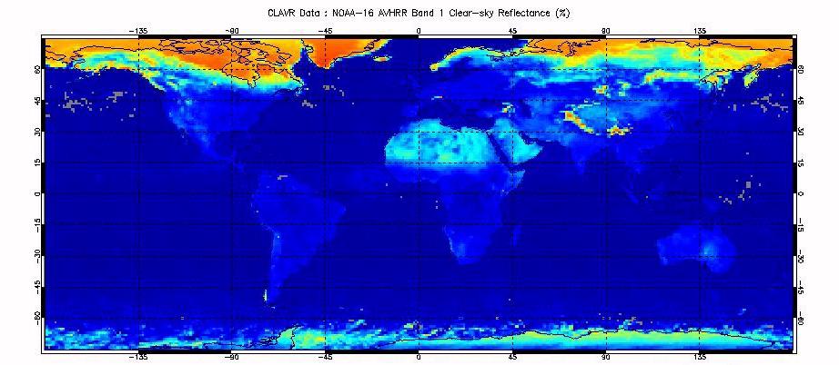
Clear Sky
Reflectances from AVHRR and MODIS Compared: Clear sky
reflectances from the Moderate-resolution Imaging Spectrometer
(MODIS) and the Advanced Very High Resolution Radiometer (AVHRR) were
compared for April, 2003. MODIS data were processed using the
cloud mask developed at the Cooperative Institute for
Meteorological Satellite Studies (CIMSS); the
AVHRR data was processed using the Clouds from AVHRR Experimental
System (CLAVR-x) system that is currently being implemented into NOAA's
Satellite and Information operationals. Results
from the two products indicate rough agreement between the two cloud
masks. Close inspection reveals the
improvement offered by MODIS’s additional channels in some regions. (A.
Heidinger, E/RA2, 608-263-6757, R. Frey, CIMSS, 608-265-5354)
(Click on images to enlarge)
Figure caption: These two figures show the mean clear sky 0.65 micron
reflectance observed by MODIS (top) and NOAA-16/AVHRR (bottom) for
April, 2003. Evident is the considerable Northern Hemisphere snow cover
as well as other surface features.
LOOKING AHEAD: