 |
CIMSS-NOAA Weekly Report
[ Archive ] |
 |
ASPB AND CIMSS WEEKLY HIGHLIGHTS FOR THE WEEK ENDING FEBRUARY 21, 2003
IN THE PRESS:
ITEMS FOR THE ADMINISTRATOR:
ITEMS FOR THE ASSISTANT ADMINISTRATOR:
ITEMS FOR THE OFFICE DIRECTOR, ORA:
Whittaker Awarded
Unidata's DeSouza Award: Tom Whittaker of the Cooperative
Institute for Meteorological Satellite Studies (CIMSS) was awarded
Unidata's Russel L. DeSouza award at the annual meeting of the American
Meteeorological Society (AMS) last week in Long Beach, California.
Mr. Whittaker was given the award "for playing an instrumental role in
molding Unidata's future through participation in technical working
groups, advisory committees, and providing guidance toward the
development of community visualization and analysis tools". Additional
information on the award is available at http://my.unidata.ucar.edu/content/community/aboutRLDaward.html.
(S. Ackerman, CIMSS,
608-263-3647)
NASA, CIMSS, NWS,
and NESDIS Collaborate on Space Shuttle Analysis: Personnel from
the National Aeronautics and Space Administration (NASA), the National
Weather Service (NWS), the Cooperative Institute for Meteorological
Satellite Studies (CIMSS), and the National Environmental Satellite,
Data, and Information Service (NESDIS) collaborated recently on
meteorological data to study the Space Shuttle Columbia
tragedy. CIMSS supplied various products derived from
Geostationary Operational Environmental Satellite (GOES) data,
including winds, temperature, and moisture, to the NWS Spaceflight
Meteorology Group (SMG) at Johnson Space Center in Houston.
NWS/SMG, NESDIS, and CIMSS discussed other potential data sources,
including the MODerate-resolution Imaging Spectroradiometer (MODIS),
Polar Orbiting Environmental Satellite (POES) systems, and numerical
model analyses. (J.
Nelson, CIMSS, 608-263-6013, Doris A. Rotzoll,
JSC-ZS8,NWS/SMG, 281-483-1041, T. Schmit, E/RA-2,608-263-0291, C.
Schmidt, CIMSS, 608-262-7973, D. Stettner, CIMSS, 608-262-8850, C.
Velden, CIMSS, 608-262-9168)
Bill Raymond
Remembered at CIMSS: On Thursday, February 20, a memorial
gathering was held at the Cooperative Institute for Meteorological
Satellite Studies (CIMSS) to remember the works and life of Dr. William
H. Raymond, who died of a heart attack on February 5, 2003. Bill
was a senior scientist at CIMSS, having worked at the University of
Wisconsin-Madison Space Science and Engineering Center since 1982.
He specialized in atmospheric dynamics and numerical modeling.
Bill made significant contributions in these fields and was an author
of over 40 journal papers, including 14 as sole author. He will
be sorely missed, professionally and personally, by many at CIMSS and
within the scientific community. (G. Wade, E/RA2,
608-263-4743, R. Aune, E/RA2, 608-262-1071)
CIMSS Supplying
Forecast Guidance for THORPEX: The Cooperative Institute
for Meterological Satellite Studies (CIMSS) Regional Assimilation System
(CRAS) model is now running over the Central Pacific, supplying
forecast guidance for aircraft participating in The Observing-system
Research and Predictability Experiment (THORPEX). The CRAS is
running at 40 kilometer resolution and is nested in the National
Centers for Environmental Prediction's (NCEP) Global Forecast System
(GFS). Clouds and moisture in the CRAS are being initialized
using observations from the Geostatonary Operational Environmental
Satellite (GOES)-10 sounder and the MOderate Resolution Imaging
Spectrometer (MODIS) instrument. Daily forecast products can be
viewed at http://cimss.ssec.wisc.edu/model/pacific/pacific.html.
(R. Aune, E/RA2,
608-262-1071)
ITEMS FOR THE DIVISION CHIEF, ARAD:
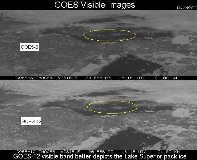
GOES and MODIS
Imagery of Ice in Lake Superior: Geostationary Operational
Environmental Satellite (GOES-8) visible imagery showed the extent of
pack ice that had formed in Lake Superior during February 2003, when
colder than normal temperatures were experienced across the western
portion of the Great Lakes region. The GOES-12 visible band showed the
ice pack more clearly than GOES-8. Terra Moderate-resolution Imaging
Spectroradiometer (MODIS) composite imagery showed even greater detail,
and also demonstrated how the use of multi-spectral imagery helps to
distinguish the ice features from any areas of cloudiness that were also
present. Image examples and animations area available on the Cooperative
Institute for Satellite Studies (CIMSS) GOES Gallery: http://cimss.ssec.wisc.edu/goes/misc/030217/030217.html.
(S. Bachmeier,
CIMSS, 608-263-3958, L. Gumley, CIMSS, 608-265-5358, T. Schmit, E/RA2,
608-263-0291)
 (Click on
image to enlarge)
(Click on
image to enlarge)
Discussions on Next
Generation Geostationary Imager Ozone Band: Scientists from the
Advanced Satellite Products Team (ASPT), the Cooperative Institute for
Meteorological Satellite Studies (CIMSS), the Office of Systems
Development (OSD), the Office of Research and Applications (ORA), and
NASA's Goddard Space Flight Center (GSFC) discussed the spectral width
of the ozone band on the Advanced Baseline Imager (ABI). It was
agreed upon to tighten the bandpass spectral tolerances on the 9.7
micron band, as the previous tolerances were too loose for a narrow
band near an absorption feature. D. Chesters of NASA GSFC suggested
broadening the band from 9.6-9.8 microns to 9.42-9.8 microns.
Simulations will need to be done to demonstrate the advantages of the
wider band. (T. Schmit,
E/RA2, 608-263-0291, M. Gunshor,
CIMSS, 608-263-1146)
Abstracts Submitted
for IGARSS03: The following abstracts were submitted for
presentation at the 2003 International Geoscience and Remote Sensing
Symposium (IGARSS03), to be held in Toulouse, France on July 21-25:
"Cloud retrievals from combination of high spatial resolution imager and
high spectral resolution sounder radiance measurements" by J. Li, W. P.
Menzel, H-L. Huang, and T. Schmit, and "AIRS sub-pixel surface and cloud
type classification using high spatial resolution MODIS multi-spectral
band radiance measurements" by F. Sun, J. Li, W. P. Menzel, and T.
Schmit. (J. Li, CIMSS,
608-262-3755)
AMS Satellite
Conference Summary: Numerous posters and oral presentations were
given by Cooperative Institute for Meteorological Satellite Studies
(CIMSS) and Advanced Satellite Products Team (ASPT) scientists at the
American Meteorological Society (AMS) 12th Conference on Satellite
Meteorology and Oceanography. The conference was part of the AMS
annual meeting held in Long Beach, CA from February 10-14, 2003.
E. Prins served as chair of the Environmental Applications session, and
also participated in a meeting of the conference organizing committee.
A (possibly incomplete) list of the CIMSS/ASPT posters and oral
presentations given at the satellite conference or other symposia is
included below. (J. Key,
E/RA2, 608-263-2605)
Ackerman, S. A., D. Tobin, R. Knuteson, P. Antonelli, H. Revercomb, and
K. Vinson, Fire detection and properties from High-spectral resolution
infrared observations: New Technology, Methods and Future Sensors.
J. Daniels, C. Velden, G. Dengel, D. Stettner, and W. Bresky, Status
and development of GOES wind products at NOAA/NESDIS.
DeMaria, M., M. Mainelli, L. K. Shay, J. A. Knaff, and J. P. Kossin,
Improvements in real-time statistical tropical cyclone intensity
forecasts using satellite data.
Feltz, W. F., J. P. Nelson III, T. J. Schmit, and G. S. Wade,
Validation of GOES-8/11 Sounder Derived Products During IHOP 2002 Field
Experiment.
Feltz, W. F., D. Posselt, J. Mecikalski, G. S. Wade, and T. J. Schmit,
12 June 2002 June 2002 Rapid Water Vapor Transitions During the IHOP
Field Program. (Symp. On Observing and Understanding the Variability of
Water in Weather and Climate)
Greenwald, T. and S. Christopher, Methods for evaluating
microwave-derived satellite liquid water products.
Gunshor, M. M., D. Tobin, T. J. Schmit, and W. P. Menzel, First
satellite intercalibration comparing high spectral resolution airs with
operational geostationary imagers.
Gurka, J. J., G. J. Dittberner, P. Taylor, and T. J. Schmit, Specifying
the requirements for imaging and sounding capabilities on the GOES-R
series.
Kossin, J. P., T. L. Olander, and C. S. Velden, A new statistical
method for estimating tropical cyclone intensity from GOES-IR imagery.
Li, J., T. J. Schmit, F. Sun, and W. P. Menzel, Surface and atmospheric
retrievals from the future goes sounder-Advanced Baseline Sounder (ABS).
E. Prins, A two-year analysis of fire activity in the Western
Hemisphere as observed with the GOES wildfire automated biomass burning
algorithm.
Posselt, D. J., W. F. Feltz, T. Schmit, and D. D. Turner, Verification
of mesoscale numerical model forecasts using remotely-sensed
observations.
Santek, D., J. R. Key and C. S. Velden, Real-time derivation of cloud
drift and water vapor winds in the polar regions from MODIS data.
Schmit, T. J., W. P. Menzel, J. Sieglaff, J. P. Nelson, III, M. K.
Griffin, and J. J. Gurka, Channel selection for the next generation
geostationary advanced baseline imagers.
Schreiner, A.J., T. J. Schmit, C. Kpken, X. Su, C. Holland, and J. A.
Jung, Introducing the GOES Imager Clear-Sky Brightness Temperature
(CSBT) product.
Sieglaff, J. M. and T. J. Schmit, Vegetation monitoring and thin cirrus
detection on the next generation GOES imager.
Strabala, K. I., L. G. Gumley, T. Rink, H.-L. Huang and R. Dengel,
MODIS/AIRS instrument direct broadcast products and applications.
C. Velden, UW-CIMSS satellite products: recent research and
developments.
Vukicevic, T., T. Greenwald, M. Zupanski, D. Zupanski, and T. Vonder
Haar, Potential impact of visible and infrared satellite measurements in
cloud data assimilation.
Wade, G. S., T. J. Schmit, W. F. Feltz, J. P. Nelson, III, and A. J.
Schreiner, GOES-11 and GOES-8 Sounders during the International H2O
Project (IHOP) 2002 field Experiment, 2003.
VISITORS:
NEXT WEEK:
LOOKING AHEAD:
Archived Weeklies Page