[ Archive ]
| CIMSS-NOAA Weekly Report
[ Archive ] |
IN THE PRESS:
ITEMS FOR THE ADMINISTRATOR:
ITEMS FOR THE ASSISTANT ADMINISTRATOR:
ITEMS FOR THE OFFICE DIRECTOR, ORA:
Cloudsat and Calipso Meeting: A joint meeting of the science teams for the Cloudsat and Calipso missions was held in Broomfield, Colorado. Both missions will fly together in formation behind the National Aeronautics and Space Administration's (NASA) Earth Observing System (EOS-AQUA) satellite and will be launched together in November 2004. These missions will provide for the first time direct observations of the vertical distribution of cloud and aerosol through the atmosphere. NOAA can benefit by using this data to validate its passive satellite products and to validate the forecast cloud fields. (A. Heidinger, E/RA2, 608-263-6757)
Kick-off Meeting
Held for Atmospheres, Ocean, and Land TAP: T. Schmit and A.
Heidinger participated (via telecon) in the kick-off meeting of the
Atmospheres, Ocean and the Land Technical Advisor Panel(TAP) on March 7,
2003. This panel will assist in translating between the stated
requirements and the specific satellite parameters for Geostationary
Operational Environmental Satellite (GOES)-R. For example, advice will
be given on which bands and spectral widths are needed for each
product. ( T. Schmit,
E/RA2, 608-263-0291, A.
Heidinger, E/RA2, 608-263-6757)
Geostationary
Fire Detection and Validation Activities in Acre, Brazil:
Over the past 2 years the Geostationary Operational Environmental
Satellite (GOES)-8 Wildfire Automated Biomass Burning Algorithm
(WF_ABBA) has been used to monitor fire activity associated with new
agricultural activity in Acre, Brazil along a new road being constructed
across the Andes from Brazil to Peru. During the 2002 fire season
a ground truth validation effort was conducted in Acre to determine the
capability of the GOES-8 WF_ABBA to detect agricultural burning in the
region. The GOES Wildfire ABBA identified 84% of the 88
fires that were monitored by on-site survey teams; the majority of the
fires not detected with the GOES WF_ABBA were obscured by clouds.
This validation effort was presented by K. McClaid-Cook (University of
New York-SUNY, Albany/ Universidade Federal do Acre) at the 99th Annual
Meeting of the Association of American Geographers in New Orleans on
March 7, 2003. (J.
Feltz, CIMSS, 608-263-3434, E. Prins, E/RA2,
530-271-2256)
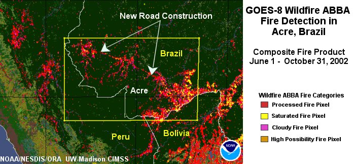
(Click on image to enlarge)
Figure: This GOES-8 Wildfire ABBA fire composite shows fire
activity in western Brazil in the state of Acre from June through
October 2002. Fires associated with deforestation and agricultural
management are evident along a new road being built across the Andes
from Brazil to Peru.
ITEMS FOR THE DIVISION CHIEF, ARAD:
CIMSS
Interactive Display Program Now on Linux: The Cooperative
Institute for Meteorological Satellite Studies (CIMSS) interactive
display program has been converted to run on Linux computers. This
program displays gridded fields and observational (point) data with
human interaction on a computer screen. More work remains to be done
but the basic display functions have been converted and tested. (G. Callan, E/RA2,
608-263-3951)