[ Archive ]
| CIMSS-NOAA Weekly Report
[ Archive ] |
IN THE PRESS:
ITEMS FOR THE ADMINISTRATOR:
ITEMS FOR THE ASSISTANT ADMINISTRATOR:
ITEMS FOR THE OFFICE DIRECTOR, ORA:
ITEMS FOR THE DIVISION CHIEF, ARAD:
NASA SHARP Students Visit SSEC: On
Friday, June 27, 2003, 21 students participating in the National
Aeronautics and Space Administration (NASA) Summer High School
Apprenticeship Research Program (SHARP) at the University of
Wisconsin-Madison (UW) visited the UW Space Science and Engineering
Center (SSEC). T. Gregory (SSEC) hosted the group and provided
building tours. G. Wade and A. Pichon gave presentations to both
groups of 10+ students, promoting the NOAA presence at UW.
Realtime satellite data and products at the UW Cooperative Institute for
Meteorological Satellite Studies (CIMSS) were shown and explained.
Information about and opportunities with NOAA's newer Cooperative
Remote Sensing Science and Technology Center (CREST) were also
provided. (G.S. Wade,
E/RA2, 608-263-4743; A. Pichon, E/RA2, 608-263-4457)
 (Click on image
to enlarge)
(Click on image
to enlarge)
Modernized Sensor Processing System GOES-12 Test: The Space Science and Engineering Center (SSEC) Data Center responded to a request from Keith McKenzie to help evaluate another test of the Modernized Sensor Processing System (MSPS) by ingesting, and evaluating Geostationary Operational Environmental Satellite (GOES)-12 data, which is being transmitted through GOES-11. The Data Center pointed their backup antenna to GOES-11, activated a backup SSEC Desktop Ingestor and archived several days of raw data. The test data were evaluated by NESDIS and Cooperative Institute for Meteorological Satellite Studies (CIMSS) scientists (T. Schmit, J. Robaidek, M. Gunshor). A presentation was sent to Keith McKenzie. (T. Schmit, E/RA2, 608-263-0291, M. Gunshor, CIMSS, 608-263-1146, D. Wade, CIMSS, 608-263-0527)
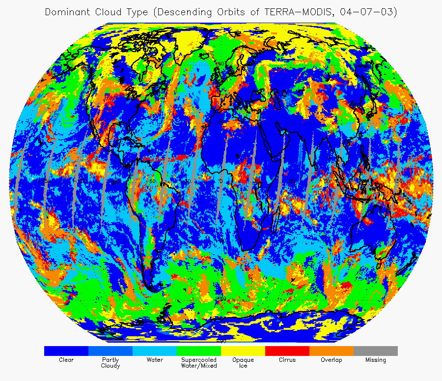
Global MODIS Data Processed With VIIRS Cloud
Type Algorithm: An algorithm to determine cloud type on a global
scale was developed for the future Visible and Infrared Imaging
Radiometer Suite (VIIRS). VIIRS data was simulated using Moderate
Resolution Imaging Spectroradiometer (MODIS) data and the cloud types
were determined as in the Clouds from AVHRR (CLAVR) software
suite. MODIS data was processed globally for April 1, 2003; the
results were consistent with surface-based climatologies. The
retrieval of cloud properties is heavily influenced by cloud type, so
an accurate determination of cloud type is important. Future work
will be aimed at comparing the results of this VIIRS algorithm to the
MODIS and VIIRS contractor algorithms. (M. Pavolonis, CIMSS,
608-263-9597, A. Heidinger, E/RA2, 608-263-6757)
 (Click on image to enlarge)
Validation of AVHRR-derived Snow Albedo: J. Box of the Byrd Polar Research Center at the Ohio State University compared the surface broadband albedo values in the extended Advanced Very High Resolution Radiometer Polar Pathfinder (APP-x) data set, a product of the Advanced Satellite Products Team (ASPT) and the Cooperative Institute for Meteorological Satellite Studies (CIMSS), to surface-based measurements made over the Greenland ice sheet. Dr. Box found that the mean difference between the satellite-derived and surface-based albedos is near zero with a root-mean-square error of approximately 5%, indicating the high quality of the satellite estimates. (J. Key, E/RA2, 608-263-2605)
VISITORS: