[ Archive ]
| CIMSS-NOAA Weekly Report
[ Archive ] |
IN THE PRESS:
ITEMS FOR THE ADMINISTRATOR:
ITEMS FOR THE ASSISTANT ADMINISTRATOR:
ITEMS FOR THE OFFICE DIRECTOR, ORA:
Weather Channel Uses SSEC/CIMSS Imagery of
Fall Color Changes:
A series of Terra MODerate-resolution Imaging Spectroradiometer
(MODIS) true-color images from four separate days in early October 2003
shows the change in vegetation color (from green to vivid autumnal
colors) across the state of Wisconsin. The MODIS data were acquired and
processed by the Space Science and Engineering Center (SSEC)
Direct Broadcast site. On Saturday, October 11 the Weather Channel used
the MODIS images generated at the Cooperative Institute for
Meteorological Satellite Studies (CIMSS) to show the changing fall
colors. See the changes at: http://cimss.ssec.wisc.edu/goes/misc/modis/autumn/modis_anim.html.
((L. Gumley, SSEC, 608-265-5358, S. Bachmeier, CIMSS,
608-263-3958, S. Ackerman,
CIMSS,
608-263-3647)
Workshop on High-Latitude Numerical Weather Predicition and Polar Winds: J. Key, C. Velden (Cooperative Institute for Meteorological Satellite Studies, CIMSS), D. Santek (CIMSS), and H. Berger (CIMSS and UK MetOffice) attended the Workshop on Short- to Medium-Range Regional Numerical Weather Prediction (NWP) in the Arctic and Antarctic, held in Fairbanks, Alaska, October 8-10. The workshop was held at the International Arctic Research Center (IARC), University of Alaska. Key and Velden convened a workshop on polar winds data assimilation as part of the high-latitude NWP workshop. Speakers for the polar winds workshop were from CIMSS, NOAA NESDIS (J. Daniels and J. Key), the European Centre for Medium-Range Weather Forecasts (ECMWF), the NASA Global Modeling and Assimilation Office (GMAO, formerly the Data Assimilation Office), the UK MetOffice, and the Canadian Meteorological Centre. (J. Key, E/RA2, 608-263-2605, C. Velden, CIMSS, 608-262-9168, D. Santek, CIMSS, 608-263-7410, J. Daniels, E/RA2)
ITEMS FOR THE DIVISION CHIEF, ARAD:
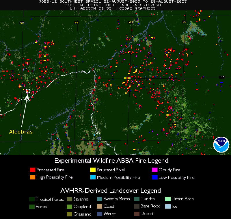
GOES WF_ABBA Fire Products Provided to
Researchers Verifying Fires in Southwest Brazil: Composites
of unfiltered Geostationary Operational Environmental Satellite (GOES)
Wildfire Automated Biomass Burning Algorithm (WF_ABBA) observed fires
for August 22-29, 2003 were provided to I.F. Brown (Woods Hole Research
Center and Universisdade Federal Fluminense, Rio Branco). An
unfiltered analysis indicates that there has been no temporal filtering
to remove fires which occur only once in a 12-hour period. I.F.
Brown is using the data to study recent large-scale fires (3,000-10,000
ha) in the Alcobras colonization project which consists of
approximately 1,000 families living in an area roughly 15,000 ha in
size. The wildfires were devastating to the area with many of the
settlers homes burned to the ground. (J. Feltz, CIMSS,
608-263-3434, E. Prins, E/RA2, 530-271-2256).
 (Click image to
enlarge)
(Click image to
enlarge)
Figure Caption: GOES WF_ABBA observed fires in the region of the
Alcobras Colonization Project (outlined with a white box) for 22-29
August 2003. All fire flags have been plotted and the unfiltered
data set has been used.
Biomass Burning Seminar at the Desert Research
Institute: E. Prins presented a seminar on October 10 at the
Desert Research Institute in Reno, Nevada as part of the Cooperative
Institute for Atmospheric Sciences and Terrestrial Applications
(CIASTA) seminar series. The title of the talk was
"Applications of Meteorological Satellites in Biomass Burning
Environmental Monitoring Activities" and included an overview of
current and future applications of environmental satellites in biomass
burning monitoring activities. E. Prins met with M. Pitchford
(NOAA Air Resources Laboratory), M. Green (director, CIASTA) and
several other DRI researchers to discuss possible collaborative efforts
especially in the area of air quality monitoring with the next
generation Geostationary Operational Environmental Satellite (GOES-R)
Advanced Baseline Imager (ABI) and sounder.
(E. Prins, E/RA2,
530-271-2256)
Beta Test of New VISIT Training Lesson: A
beta test of a new Virtual Institute for Satellite Integration
Training (VISIT) training lesson "Water Vapor Channel
Satellite Imagery" was conducted with members of the
VISIT team and forecasters at the National Weather
Service office in Milwaukee/Sullivan. This new lesson
will be added to the VISIT training calendar beginning
in mid-October 2003.
(S. Bachmeier,
CIMSS, 608-263-3958)
Presentation on HES Clear Radiances at NASA
Goddard: A
presentation entitled "Clear radiances from the GOES-R Sounder:
Hyperspectral Environmental Suite (HES)" was given via teleconference
at the
National Aeronautics and Space Administration (NASA) Goddard Space
Flight Center on October
1, 2003. Inputs for were received from Jun Li, H-L Allen Huang
from
the Cooperative Institute for Meteorological Satellite Studies (CIMSS).
The concept of using high spatial resolution imager data for HES
sub-pixel characterization was discussed. The presentation is available
upon request. (T. Schmit,
E/RA2,
608-263-0291)
Memo on Accepting the Spectral Tolerance of the
ABI 13.3
um Band: To reduce program risk, it
was
suggested that the Advanced Baseline Imager (ABI) 13.3 um band spectral
tolerance be relaxed. Calculations were done to determine the
sensitivity
of a brightness temperature for each spectral tolerance. The effect on
measured brightness temperatures of widening the spectral tolerance to
+/-0.06 um will be less than the specified noise. Given if the system
spectral response functions are still well characterized, this affect
is
not an error, but a correctable satellite-to-satellite difference and
hence the relaxation to a tolerance of +/- 0.06 um was accepted. (T. Schmit, E/RA2,
608-263-0291)
Paper Submitted on the Synergistic Use of
MODIS and AIRS for ABI and HES Simulations: The Advanced Baseline
Imager (ABI) on
Geostationary Operational Environmental Satellite (GOES)-R will provide
at high spatial resolution (~2 km) and high temporal resolution (better
than every 15 minutes), a cloud mask (CM), surface and cloud types
(SCT),
cloud phase (CP), cloud-top pressure (CTP), effective cloud amount
(ECA),
cloud particle size (CPS), and cloud optical thickness (COT). The
HES will be able to provide CTP, ECA, CPS, COT at coarser spatial
resolution (~10 km) but with much better accuracy using its high
spectral
resolution measurements. The combined ABI/HES system offers the
opportunity for cloud products improved over those possible from either
system alone; this is demonstrated in a paper with both simulated and
real radiances from MODerate-resolution Imaging Spectroradiometer
/Atmospheric InfraRed Sounder (MODIS/AIRS)
measurements. The paper, entitled "Synergistic use of MODIS
and AIRS in a
variational retrieval of cloud parameters", was submitted to
Journal of Applied Meteorology; the authors are Jun Li, W. Paul
Menzel, Wenjian Zhang, Fengying Sun, Timothy J. Schmit, James, J.
Gurka,
and Elisabeth Weisz. (J. Li). (T.
Schmit, E/RA2,
608-263-0291)