[ Archive ]
| CIMSS-NOAA Weekly Report
[ Archive ] |
IN THE PRESS:
ITEMS FOR THE ADMINISTRATOR:
ITEMS FOR THE ASSISTANT ADMINISTRATOR:
ITEMS FOR THE OFFICE DIRECTOR, ORA:
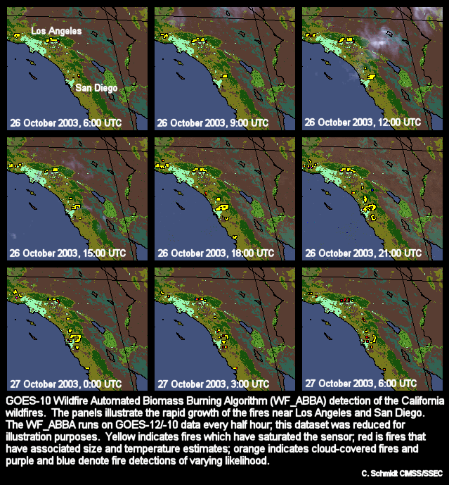
WF_ABBA Documents California Fires:
In late October the Geostationary Operational Environmental Satellite
(GOES) Wildfire Automated Biomass Burning Algorithm (WF_ABBA) fire
products documented the progress of the California fires near Los
Angeles and San Diego. The rapid growth and intensification of
the fires due to the Santa Ana winds was captured by the high temporal
resolution fire detection data. Most fires burned hot enough to
saturate the sensor on GOES-10, preventing estimates of size and
temperature. The attached figure shows nine snapshots of the
development of the fires three hours apart on 26-27 October 2003.
The WF_ABBA products are produced at the Cooperative Institute for
Meteorological Satellite Studies (CIMSS) as part of collaborations with
the NOAA, the U.S. Navy, and NASA. (C. Schmidt, CIMSS,
608-262-7973, E. Prins, E/RA2, 530-271-2256, J. Feltz, CIMSS,
608-263-3434)
 (Click image to
enlarge)
(Click image to
enlarge)
SSEC Direct Broadcast Data Use by OSEI Team: NOAA's Operational Significant Events Imagery (OSEI) team produces imagery of significant environmental events that are visible in remotely-sensed data. While the OSEI team obtains much of their satellite data from NASA and NOAA, much of the imagery is obtained from the University of Wisconsin Space Science and Engineering Center's (SSEC) Direct Broadcast site. Aiwu Li of the OSEI team said that SSEC's data is preferred "because of its longer granules and timeliness. The Moderate Resolution Imaging Spectroradiometer (MODIS) level 1B data has been playing a vital role in hazard mapping, such as locating hot spots, smoke, snow/ice cover, volcano eruption, ocean events, etc.". (L. Gumley, CIMSS, 608-265-5358, J. Key, E/RA2, 608-263-2605)
NOAA-12 AVHRR Calibration Paper Published:
A paper on the calibration of NOAA-12's Advanced Very High Resolution
Radiometer (AVHRR) was published in the International Journal of
Remote Sensing. The study used time series of desert observations
to derive a post-launch correction for the NOAA-12 AVHRR. This is
the first time this technique has been applied to AVHRR data from a
satellite in a morning orbit. The calibration of NOAA-12 is
important because its lifetime spans from 1991 to the present and
offers a long and continous data-record. (A. Heidinger, E/RA2,
608-263-6757, J. Sullivan, E/RA1, N. Rao, E/RA1)
ITEMS FOR THE DIVISION CHIEF, ARAD:
NASA SPoRT Meeting: T. Schmit attended the annual National Aeronautics and Space Administration (NASA) Short-term Prediction Research and Transition (SPoRT) Center 2003 Science Advisory Committee (SAC) Meeting on behalf of member W. P. Menzel. The meeting was Thursday October 30, 2003 in Huntsville, AL at the National Space Science and Technology Center. Results from fiscal year 2003 and plans for FY 2004 were presented and reviewed by the SAC. (T. Schmit, E/RA2, 608-263-0291)
Graduate Seminar on Radiative Transfer Applications: On Friday, October 31, 2003, J. Key gave a presentation in the Department of Atmospheric and Oceanic Sciences, University of Wisconsin, graduate seminar series titled "An In-House Radiative Transfer Model: Description and Applications". The talk provided an overview of the Streamer radiative transfer model (http://stratus.ssec.wisc.edu) and applications to the remote sensing of cloud properties and the radiation budget. (J. Key, E/RA2, 608-263-2605)
VISITORS: