[ Archive ]
| CIMSS-NOAA Weekly Report
[ Archive ] |
IN THE PRESS:
ITEMS FOR THE ADMINISTRATOR:
ITEMS FOR THE ASSISTANT ADMINISTRATOR:
ITEMS FOR THE OFFICE DIRECTOR, ORA:
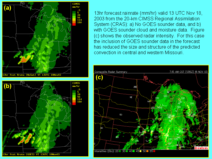
GOES Sounder Products Improve Prediction of
Convection: The realtime, 20km Cooperative Instititue for
Meteorological Satellite Studies (CIMSS) Regional Assimilation System
(CRAS) forecast generated on November 18 at 00UTC produced a single,
large area of convection in western Missouri, 13 hours into the
forecast. When cloud-top pressure and 3-layer precipitable water
from the Geostationary Operational Environmental Satellite (GOES)-12
sounder were included in the initialization, the CRAS generated two
areas of convection which were verified using a composite radar
intensity. It is believed that the improved forecast resulted from
changes in the horizontal gradients of water vapor and cloud water that
were generated when the single field-of-view GOES sounder information
was included. (R. Aune,
E/RA2,
608-262-1071)
 (Click image to enlarge)
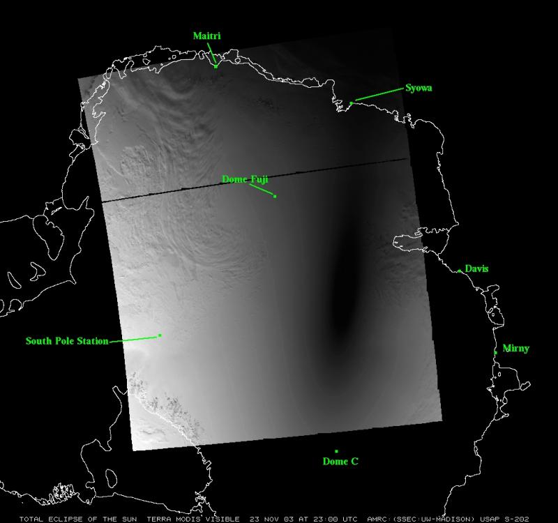
Solar Elipse Over Antarctica Captured in MODIS
Imagery: A total solar eclipse that occured Sunday November 23,
2003
between 22:25 UTC and 23:15 UTC was visible in Moderate Resolution
Imaging Spectroradiometer (MODIS imagery over Antarctica. Mathew
Lazzara of the Space Science and Engineering Center's (SSEC) Antarctic
Meteorological Research Center (AMRC) compiled satellite imagery
provided by
NOAA NESDIS (G. Legg, OSDPD and J. Key, ORA). AMRC was asked by Japan's
NHK television station to provide specific coverage of the eclipse. The
results are on AMRC's real-time page: http://amrc.ssec.wisc.edu/amrc/realtime.html.
(M. Lazzara, SSEC, 608-262-0436, (J. Key, E/RA2,
608-263-2605)
WMO Workshop on Extratropical Transition of Tropical Cyclones: C. Velden (Cooperative Institute for Meteorological Satellite Studies, CIMSS) participated in a workshop sponsored by the World Meteorological Organization (WMO) on the extratropical transition (ET) of tropical cyclones, which was held in Halifax, Nova Scotia. A paper was presented on satellite-based techniques designed to alert forecasters on how to discriminate the ET process. The techniques make use of both infrared (Geostationary Operational Environmental Satellite (GOES) multispectral) and microwave (Advanced Microsave Sounding Unit (AMSU), Tropical Rainfall Measuring Mission (TRMM), Special Sensor Microwave Imager (SSMI), and Quikscat) measurements. A second paper was given on the Thorpex program. Velden was a co-organizer of the workshop which was hosted by the Canadian Meteorological Center and involved an international scientific community. (C. Velden, CIMSS, 608-262-9168)
ITEMS FOR THE DIVISION CHIEF, ARAD:
GOES-R AOL TAP Meeting: On Wednesday,
November 25, at an Atmosphere, Ocean, Land (AOL) Technical Advisory
Panel (TAP) meeting, approval was given for slightly shifting
(spectrally) the Advanced Baseline Imager (ABI) water vapor bands. The
first change gives more precision to the spectral width of one of the
bands. This will synch up on the longwave side with the spectral width
of the Geostationary Operational Environmental Satellite
(GOES)-12/N/O/P imagers. Other changes will help the ABI sensor to do a
better job monitoring some hazards, without jeopardizing the water
vapor missions. It will allow a cleaner sulfur dioxide (SO2)
measurement by slightly shifting both SO2 bands for an "on" and "off"
absorption feature.
(T. Schmit, E/RA2,
608-263-0291)
Proposal Review: R. Aune completed a review of a proposal submitted to The Observing System Research and Predictability Program (THORPEX). (R. Aune, E/RA2, 608-262-1071)
VISITORS: