[ Archive ]
| CIMSS-NOAA Weekly Report
[ Archive ] |
IN THE PRESS:
ITEMS FOR THE ADMINISTRATOR:
ITEMS FOR THE ASSISTANT ADMINISTRATOR:
ITEMS FOR THE OFFICE DIRECTOR, ORA:
MODIS and GOES Images of Texas Dust Storm:
Multispectral imagery from the Aqua Moderate Resolution Imaging
Spectroradiometer (MODIS) revealed significant structure to the large
area of blowing sand and dust across Texas and New Mexico on December
15, 2003. 1000-meter and 250-meter resolution "true color" images are
available on the SSEC MODIS Gallery (http://terra.ssec.wisc.edu/~gumley/images.html).
The Geostationary Operation Environmental Satellite (GOES-10)
"split-window" InfraRed difference product showed that much of this
airborne dust was rapidly transported northeasward to the Great Lakes
region within 24 hours, where several public reports of "red rain" were
due to this dust falling along with precipitation. GOES-10 images and
animations are available on the Cooperative Institute for
Meteorological Satellite Studies (CIMSS) GOES Gallery (http://cimss.ssec.wisc.edu/goes/misc/031215/031215.html).
(L. Gumley, CIMSS, S.
Bachmeier,
CIMSS, 608-263-3958).
NPOESS CAL/VAL Meeting: An all day
meeting was held concerning the proposed calibration and validation
activities for the NPOESS era. The first half of the meeting
consisted of Northrup Grumman personnel discussing the current planned
activities. The second half of the meeting consisted of NESDIS
briefings on the experience and projected activities of NESDIS in the
area of calibration and validation. A. Heidinger gave a talk on cloud
validation activities within NESDIS and highlighted several activities
occurring in cooperative institutes. (A. Heidinger, E/RA2,
608-263-6757)
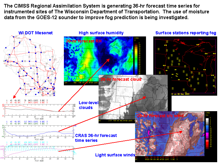
CRAS Forecast Uses GOES-12 Moisture to Predict
Fog: Scientists at the Cooperative Institute for Meteorological
Satellite Studies (CIMSS) are using the CIMSS Regional Assimilation
System to investigate whether water vapor and cloud observations from
the Geostationary Operational Environmental Satellite (GOES)-12 can be
used to improve the prediction of fog over Wisconsin roadways.
Three-layer precipitable water and cloud-top pressure retrievals from
the GOES-12 sounder are being assimilated into the 20-km resolution
CRAS. 36-hour forecast time series are being generated for
instrumented sites of the Wisconsin Department of Transportation, which
will be used to validate fog forecasts, in addition to fog products
generated by GOES-12. Results for a recent fog event are encouraging. (R. Aune, E/RA2, 608-262-1071)
 (Click image to enlarge)
ITEMS FOR THE DIVISION CHIEF, ARAD:
AVHRR Reprocessing Workshop: A
workshop was held in the NOAA Science Center on December 15 to discuss
the activities within the NESDIS Office of Research and Applications
concerning the reprocessing of the data record from the Advanced Very
High Resolution Radiometer. Several presentations were given
including ones on the AVHRR Pathfinder Atmospheres (PATMOS-x) given by
A. Heidinger and J. Key's project on AVHRR Polar Winds
Reprocessing. Other talks included efforts regarding AVHRR
calibration and navigation improvements. A report will be written
summarizing the findings. (A. Heidinger, E/RA2,
08-263-6757, Jeff Key, E/RA2, 608-263-2605)
USWRP Workshops: R. Aune attended
two workshops held by
the U. S. Weather Research Program (USWRP) in Boulder, CO. The
mission
of the first workshop on the "Design and Development of Multifunctional
Mesoscale Observing Networks in Support of Integrated Forecasting
Systems" was to identify challenges, needs, and opportunities involved
in developing future integrated atmospheric mesoscale observing,
modeling, and information delivery systems that will satisfy the future
needs of users, modelers and forecasters. The second workshop was
on
"The Future of Regional Real-time Weather Prediction", investigating
the
advantages/disadvantages of centralized versus distributed processing.
Aune gave a presentation on his work using the CIMSS Regional
Assimilation System to assess the impact of satellite observation on
regional numerical weather prediction, demonstrating that information
from satellites can be used locally to improve numerical weather
forecasts. (R. Aune, E/RA2,
608-262-1071)
Seminar on Cloud Typing Given at the NOAA Office of Research and Applications: Two algorithms for detecting cloud overlap and determining cloud type with daytime satellite data were presented at a Office of Research and Applications (ORA) seminar by M. Pavolonis of the Cooperative Institute for Meteorological Satellite Studies (CIMSS). The first algorithm utilizes spectral channels that are available on the Advanced Very High Resolution Radiometer (AVHRR), and is part of the Extended Clouds from AVHRR (CLAVR-x) processing system. The second algorithm incorporates data from additional spectral channels that are available on the Moderate Resolution Imaging Spectroradiometer (MODIS) and will be available on the Visible/Infrared Imager/Radiometer Suite (VIIRS). VIIRS is the imager that will replace the AVHRR on board the next generation of NOAA polar-orbiting satellites. (M. Pavolonis, CIMSS, 608-263-9597, A. Heidinger, E/RA2, 608-263-6757)
Visit to ASPB and CIMSS: E. Prins was in Madison, Wisconsin on December 17-19 to meet with Advanced Satellite Products Branch (ASPB) and Cooperative Institute for Meteorological Satellite Studies (CIMSS) scientists. Discussions with CIMSS focused on new funding opportunities, upcoming conferences, hardware needs, and research plans for the coming year. The CIMSS biomass burning monitoring team hopes to add a Master's level graduate student to the group to focus on multi-sensor comparisons and data fusion issues. E. Prins also participated in the ASPB monthly meeting. (E. Prins, E/RA2, 530-271-2256)
VISITORS: