[ Archive ]
| CIMSS-NOAA Weekly Report
[ Archive ] |
IN THE PRESS:
ITEMS FOR THE ADMINISTRATOR:
ITEMS FOR THE ASSISTANT ADMINISTRATOR:
ITEMS FOR THE OFFICE DIRECTOR, ORA:
MODIS and GOES Images of Texas Dust Storm:
Multispectral imagery from the Aqua Moderate Resolution Imaging
Spectroradiometer (MODIS) revealed significant structure to the large
area of blowing sand and dust across Texas and New Mexico on December
15, 2003. 1000-meter and 250-meter resolution "true color" images are
available on the SSEC MODIS Gallery (http://terra.ssec.wisc.edu/~gumley/images.html).
The Geostationary Operation Environmental Satellite (GOES-10)
"split-window" InfraRed difference product showed that much of this
airborne dust was rapidly transported northeasward to the Great Lakes
region within 24 hours, where several public reports of "red rain" were
due to this dust falling along with precipitation. GOES-10 images and
animations are available on the Cooperative Institute for
Meteorological Satellite Studies (CIMSS) GOES Gallery (http://cimss.ssec.wisc.edu/goes/misc/031215/031215.html).
(L. Gumley, CIMSS, S.
Bachmeier,
CIMSS, 608-263-3958).
NPOESS CAL/VAL Meeting: An all day
meeting was held concerning the proposed calibration and validation
activities for the NPOESS era. The first half of the meeting
consisted of Northrup Grumman personnel discussing the current planned
activities. The second half of the meeting consisted of NESDIS
briefings on the experience and projected activities of NESDIS in the
area of calibration and validation. A. Heidinger gave a talk on cloud
validation activities within NESDIS and highlighted several activities
occurring in cooperative institutes. (A. Heidinger, E/RA2,
608-263-6757)
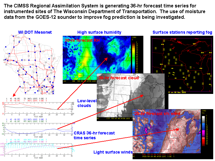
CRAS Forecast Uses GOES-12 Moisture to Predict
Fog: Scientists at the Cooperative Institute for Meteorological
Satellite Studies (CIMSS) are using the CIMSS Regional Assimilation
System to investigate whether water vapor and cloud observations from
the Geostationary Operational Environmental Satellite (GOES)-12 can be
used to improve the prediction of fog over Wisconsin roadways.
Three-layer precipitable water and cloud-top pressure retrievals from
the GOES-12 sounder are being assimilated into the 20-km resolution
CRAS. 36-hour forecast time series are being generated for
instrumented sites of the Wisconsin Department of Transportation, which
will be used to validate fog forecasts, in addition to fog products
generated by GOES-12. Results for a recent fog event are encouraging. (R. Aune, E/RA2, 608-262-1071)
 (Click image to enlarge)
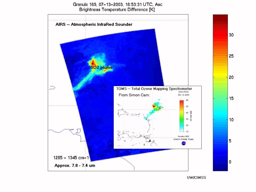
AIRS Captures SO2 Event from the Soufriere
Hills Volcano: A sulfure dioxide (SO2) plume from July 2003 was
observed with the Atmospheric InfraRed Sounder (AIRS). This plume was
from the Soufriere Hills volcano on Montserrat Island, West Indies.
Good agreement was found between a set of AIRS channel differences
(suggested by L. Strow) with SO2 estimates from TOMS (Total Ozone
Mapping Spectrometer; data from S. Carn of the University of Maryland,
Baltimore County). (T. Schmit,
E/RA2,
608-263-0291)
 (Click image to enlarge)
ITEMS FOR THE DIVISION CHIEF, ARAD:
AVHRR Reprocessing Workshop: A
workshop was held in the NOAA Science Center on December 15 to discuss
the activities within the NESDIS Office of Research and Applications
concerning the reprocessing of the data record from the Advanced Very
High Resolution Radiometer. Several presentations were given
including ones on the AVHRR Pathfinder Atmospheres (PATMOS-x) given by
A. Heidinger and J. Key's project on AVHRR Polar Winds
Reprocessing. Other talks included efforts regarding AVHRR
calibration and navigation improvements. A report will be written
summarizing the findings. (A. Heidinger, E/RA2,
08-263-6757, Jeff Key, E/RA2, 608-263-2605)
GOES South American ABBA Fire Products Provided for Emissions Research Effort: Geostationary Operational Environmental Satellite (GOES-8) South American Automated Biomass Burning Algorithm (ABBA) diurnal fire products for the 2000 fire season were provided to K. Longo (Brazil Instituto Nacional de Pesquisas Espaciais (INPE) Centro de Previsão de Tempo e Estudos Climáticos (CPTEC)) and J. Hoelzmann (Max Planck Institute for Meteorology, Hamburg). The data set is being used to estimate biomass burning emissions for air quality and climate change studies. Investigators are comparing the benefits of different data sources and techniques for emissions estimates. (J. Feltz, CIMSS, 608-263-3434, E. Prins, E/RA2, 530-271-2256).
Seminar on Cloud Typing Given at the NOAA
Office of Research and Applications: Two algorithms for detecting
cloud overlap and determining cloud type with daytime satellite data
were presented at a Office of Research and Applications (ORA) seminar
by M. Pavolonis of the Cooperative Institute for Meteorological
Satellite Studies (CIMSS). The first algorithm utilizes spectral
channels that are available on the Advanced Very High Resolution
Radiometer (AVHRR), and is part of the Extended Clouds from AVHRR
(CLAVR-x) processing system. The second algorithm incorporates data
from additional spectral channels that are available on the Moderate
Resolution Imaging Spectroradiometer (MODIS) and will be available on
the Visible/Infrared Imager/Radiometer Suite (VIIRS). VIIRS is
the imager that will replace the AVHRR on board the next generation of
NOAA polar-orbiting satellites. (M. Pavolonis, CIMSS,
608-263-9597, A. Heidinger, E/RA2, 608-263-6757)
Paper on Daytime Cloud Overlap Detection
Accepted: A paper titled "Daytime cloud overlap detection
from AVHRR and VIIRS" was accpeted for publication in the Journal of
Applied Meterology. The paper, by
M. Pavolonis (Cooperative Institute for Meteorological Satellite
Studies, CIMSS) and A. Heidinger, describes two automated algorithms
for detecting cloud overlap using daytime satellite imagery. (M. Pavolonis, CIMSS,
608-263-9597, A. Heidinger, E/RA2, 608-263-6757)
GOES and MODIS Radiative Transfer codes
supplied to NASA
Huntsville: Both GOES (Geostationary Operational
Environmental
Satellite) and MODIS (MODerate-resolution Imaging Spectroradiometer)
Radiative Transfer codes and files were supplied to NASA Huntsville.
With these codes and
files, forward calculations using the PFAAST (Pressure layer Fast
Algorithm for Atmospheric Transmittances) model can be
computed. (H. Woolf, CIMSS, 608-262-0986)
Feedback on the GOES Sounder Data in CLASS:
T. Schmit provided input on the access of GOES (Geostationary
Operational Environmental Satellite) Sounder data via the Comprehensive
Large Array-data Stewardship System (CLASS). The comments included
having more descriptive file names, correcting the sounder resolutions,
making available line prefix information, and giving the option for
multiple band areas. Details are available upon request.
(T. Schmit, E/RA2,
608-263-0291)
Comments Given on NASA SPoRT SAC Report:
Comments were given to the chair of the NASA Short-term Prediction
Research and Transition (SPoRT) Center 2003 Science Advisory Committee
(SAC) on a report of the October 30, 2003 SPoRT meeting in Huntsville
at the National Space Science and Technology Center. (T. Schmit, E/RA2,
608-263-0291)
VISITORS: