 |
CIMSS-NOAA Weekly Report
[ Archive ] |
 |
ASPB AND CIMSS WEEKLY HIGHLIGHTS FOR THE WEEK ENDING APRIL 23, 2004
IN THE PRESS:
ITEMS FOR THE ADMINISTRATOR:
ITEMS FOR THE ASSISTANT ADMINISTRATOR:
ITEMS FOR THE OFFICE DIRECTOR, ORA:
Being Prepared for Hazarous Weather: R. Aune
presented lectures on being prepared for hazardous weather conditions
at the Be Prepared Event sponsored by the Girl Scouts of America and
held at the St. Barnards Education Center in Middleton Wisconsin.
Fourty-seven Girl Scout troops from the surrounding area signed up for
classes conducted by representatives from 14 national and local
agencies who covered topics such as personal saftey, self
defense, first aid, and natural disasters. Mr. Aune lectured four
classes on how to be prepared for hazardous weather conditions such as
extreme heat and cold, thunderstorms, lightning, tornados, fog, and
exposure to ultraviolet sunlight. Demonstrations were given on how
NOAA's National Weather Service uses weather satellites and radar to
forecast extreme weather events, track severe weather, issue advisories
and warnings, and how this information is communicated to the public
using the internet and the NOAA Weather radio network. (R. Aune, E/RA2,
608-262-1071)
Bulletin of the American Meteorological Society
and NOAA Web Site Cover Story: An article on identifying
dust/sand storms that originate over the Saharan desert and traverse
the Atlantic tropics is the focus of the March issue of the Bulletin of
the American Meteorological Society (BAMS). The study
was done by Jason Dunion (Cooperative Institute for Marine and
Atmospheric Studies; CIMAS) and Chris Velden (Cooperative Institute for
Meteorological Satellite Studies; CIMSS), and looked
at the interaction of the air mass, known as the Saharan Air Layer
(SAL) with Atlantic tropical cyclone activity. The method uses the
Geostationary Operational Environmental Satellite (GOES)
split-window and image enhancements to track the SAL surges during the
hurricane season. Special dropsonde missions have confirmed the
signature in the GOES imagery. It is believed the dry and dusty air
associated with the SAL acts to suppress hurricane convection and
intensity. The article was also featured as a lead story by the NOAA
web site last week.
(C. Velden, CIMSS,
608-262-9168, J. Dunion, CIMAS)
ITEMS FOR THE DIVISION CHIEF, ARAD
Cloud and Radiative Flux Data from GOES
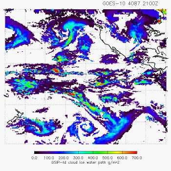
Imagers Provided to the University of Maryland: A. Heidinger
provided two months of data from the Geostationary Operational
Environmental Satellite (GOES) Surface Insolation Project (GSIP) to
Hai-Tien Lee at the University of Maryland. The products include
those from NESDIS developed algorithms such as the cloud ice water path
(IWP). The goal of this collaboration is to validate the GSIP products
and to explore their utility for numerical weather prediction.
(A. Heidinger, E/RA2,
608-263-6757)
Manuscript on AIRS Sub-pixel Cloud
Characterization with MODIS Data Accepted: The manuscript
entitled "AIRS Sub-Pixel Cloud Characterization Using MODIS Cloud
Products" has been accepted for publication by Journal of Applied
Meteorology for publication. The co-authors are Jun Li
(Cooperative Institute for Meteorological Satellite Studies, CIMSS), W.
Paul Menzel (ORA), Fengying Sun, Timothy J. Schmit (ORA), and James J.
Gurka (OSD). The PDF file on this manuscript can be download from
ftp://ftp.ssec.wisc.edu/ABS/JAM_sounder_subpixel_using_imager_Li_2004_vFINAL.pdf.
(J.
Li, CIMSS, 608-262-3755)
Manuscript Review: J. Key reviewed
a(nother)
paper for the IEEE Transactions on Geoscience and Remote Sensing.
The paper compares surface and satellite remote sensing of clouds over
Alaska. Cloud detection results based on micropulse lidar, cloud
radar, ceilometer, and Moderate Resolution Imaging Spectroradiometer
(MODIS) data are evaluated.
(J. Key, E/RA2,
608-263-2605)
VISITORS:
NEXT WEEK:
LOOKING AHEAD:
Archived Weeklies Page