 |
CIMSS-NOAA Weekly Report
[ Archive ] |
 |
ASPB AND CIMSS WEEKLY HIGHLIGHTS FOR THE WEEK ENDING OCTOBER 8, 2004
IN THE PRESS:
ITEMS FOR THE ADMINISTRATOR:
ITEMS FOR THE ASSISTANT ADMINISTRATOR:
ITEMS FOR THE OFFICE DIRECTOR, ORA
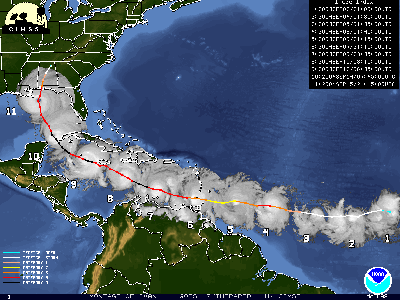
New Tropical Cyclone "Montage Image" Product:
The Cooperative Institute for Meteorological Satellite Studies (CIMSS)
Tropical Cyclone Research Team has developed a new real-time, automated
"hurricane montage" product that displays the path of each tropical
cyclone using snapshot images of the storm during its lifetime. As the
storm traverses the ocean basin the montage procedure will continually
modify the areal coverage of the display region to capture the
lifecycle of the cyclone as it develops. A color-coded history of
the storm position and intensity is also plotted along with the images
for reference. The development of this real-time product stemmed
from the popularity of the manually-derived montage products created by
Gary Wade. The product will be available on the CIMSS Tropical
Cyclone Webpage in real-time along with an archive of the various
montage images for selected storms worldwide. The montage archive can
be found at
http://cimss.ssec.wisc.edu/tropic/archive/montage/montage.html. (T.
Olander, CIMSS, 608-265-8005, C. Velden, CIMSS,
608-262-9168, G.S. Wade, E/RA2,
608-263-4743)
 (Click image to enlarge)
Above: Montage of Hurricane Ivan, September 2004.
 (Click image to enlarge)
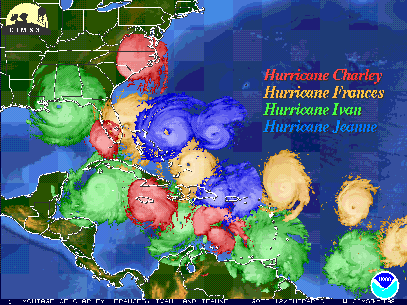
Above: This image is an example of how the automated montage images can
be used to create special products.
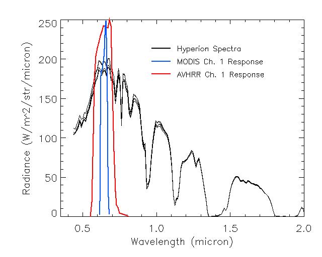
Hyperspectral Data used to Improve AVHRR
Reflectance Calibration: The Hypersion instrument is a
hyperspectral radiometer flying on NASA Earth Observer 1 (EO-1)
satellite that measures reflected solar radiation from 0.4 to 2.5
microns at a fine spectral resolution. A. Heidinger purchased a
Hypersion scene over the Libyan Desert region that has served as
calibration target for the calibration of the reflectance channels of
the NOAA's Advanced Very High Resolution Radiometer. ORA is
currently using the well calibrated Moderate Imaging Spectroradiometer
(MODIS) instrument to calibrate the reflectance channels of the AVHRR
by comparing observations over the Libyan Desert. One of the
limitations with this approach is the accounting for spectral
differences between channels. However, with Hyperion data, the
effect of the spectral difference can be accounted for without the
uncertainties of assuming the spectral variation of the surface
reflectance. The use of hyperspectral data in this way will lead
to an improvement in the AVHRR reflectance calibration for the current
and historical data. (A. Heidinger, E/RA2, 608-263-6757; C. Cao, E/RA1
301-763-8053)
 (Click image to enlarge)
ITEMS FOR THE DIVISION CHIEF, ARAD
McIDAS Users' Group Meeting: The
University of Wisconsin-Madison Space Science and Engineering Center
(SSEC) hosted the 2004 Man computer Interactive Data Access System
(McIDAS) Users' Group Meeting on October 7-8. Topics ranged from
site presentations and recent improvements to future plans.
McIDAS software and data are used extensively, both in research and
operational settings, to produce a host of images and quantitative
products throughout the meteorological community in the United States
and internationally. Examples to illustrate the diversity of
application include satellite-derived winds, Geostationary Operational
Environmental Satellite (GOES) Imager clouds, GOES Sounder derived
products, provision of select McIDAS AREA files as images compatible
with the National Weather Service (NWS) Advanced Weather Interactive
Processing System (AWIPS), forecasting support for the space shuttle,
and research activities in the Antarctic. T. Schmit and G. Wade
attended this meeting, representing the NOAA Office of Research and
Applications (ORA). (T. J. Schmit, E/RA2, 608-263-0291; G. S.
Wade E/RA2, 608-263-4742; D. M. Wade, SSEC, 608-263-0527)
VISITORS:
NEXT WEEK:
LOOKING AHEAD:
Archived Weeklies Page