 |
CIMSS-NOAA Weekly Report
[ Archive ] |
 |
ASPB AND CIMSS WEEKLY HIGHLIGHTS FOR THE WEEK ENDING APRIL 29, 2005
IN
THE PRESS:
ITEMS
FOR THE ADMINISTRATOR:
ITEMS
FOR THE ASSISTANT ADMINISTRATOR:
Polar Wind Data
Reduce Hurricane Track Forecast Errors:
Qingfu Liu at the
National Centers for Environmental Prediction (NCEP) used model impact
studies done at the Cooperative Institute for Meteorological Satellite
Studies (CIMSS) to show that the assimilation of the Moderate
Resolution Imaging Spectroradiometer (MODIS) polar wind data in
a numerical weather prediction model can reduce errors in hurricane
track
forecasts. Tests with western Atlantic and eastern Pacific
storms
outside of the tropics showed that the MODIS winds reduced the track
error from 43.6 to 34.8 nautical miles (nm) for a 12-hr forecast (68
cases) and from 301.1 to 252.0 nm for a 5-day forecast (34 cases) on
average. Additional tests will be done to verify these results.
(T. Zapotocny, CIMSS,
608-262-0800, J. Jung, CIMSS,
301-763-8204, Q. Liu, NCEP, J. Key, E/RA2, 608-263-2605, D. Santek,
CIMSS, 608-263-7410, C. Velden, CIMSS, 608-262-9168, J. Daniels, E/RA2)
Significance:
Seven numerical weather prediction centers have demonstrated that the
MODIS polar winds have a positive impact on weather forecasts not only
within the polar regions, but also in the extratropics. These
preliminary results illustrate the importance of a robust observing
system in improving global forecasts and in diagnosing teleconnections.
NOAA
Mission Goal:
Serve society's needs for weather and water information.
NOAA
Cross-Cutting Priorities:
Sound, Reliable State-of-the-Art Research
ITEMS
FOR THE OFFICE DIRECTOR, ORA
ITEMS
FOR THE DIVISION CHIEF, ARAD
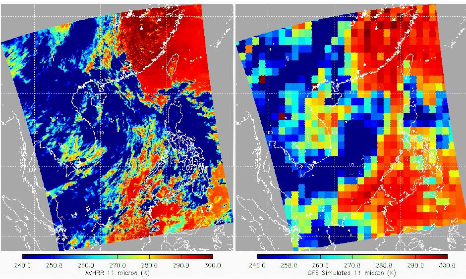
Simulation
of Satellite Observations from NCEP Forecasts:
A new version of the Clouds from AVHRR Extended (CLAVR-x) system was
developed to read in National Centers for Environmental Prediction
(NCEP) forecast fields and produce estimates of the infrared radiances
observed by the Advanced Very High Resolution Radiometer
(AVHRR). The radiative transfer model used was the Successive
Order of Interaction (SOI) model which was developed recently
as a part of a Joint Center for Satellite Date Assimilation
project. The SOI model includes the effects of multiple
scattering and was run with 8 streams to better represent the satellite
observations. This new capability will applied in the future
to diagnose the weaknesses and strengths of NCEP cloud
forecasts. (A. Heidinger, E/RA2, 608-263-6757)
 (Click image to
enlarge)
(Click image to
enlarge)
Meteorological
Satellite Coordinators Conference:
Cooperative Institute for Meteorological Satellite Studies (CIMSS)
scientists Chris Velden, Tim Olander and Tony Wimmers attended the 2005
Meteorological Satellite Coordinators Conference (MSCC) held at the
Joint Typhoon Warning Center (JTWC), Pearl Harbor, Hawaii. The
conference was intended to bring operational typhoon forecasters and
satellite-data researchers together to discuss new satellite-based
tools being designed to help improve the typhoon/hurricane forecasts in
the JTWC area of responsibility. CIMSS presentations were given on the
Advanced Objective Dvorak Technique, the morphed microwave imagery
algorithm, and the CIMSS tropical cyclone web site product suite. (C.
Velden, CIMSS, 608 262 9168)
Other Meetings and Telecons:
(None)
VISITORS:
NEXT WEEK:
LOOKING AHEAD:
Archived Weeklies Page