 |
CIMSS-NOAA Weekly Report
[ Archive ] |
 |
ASPB AND CIMSS WEEKLY HIGHLIGHTS FOR THE WEEK ENDING OCTOBER 7, 2005
IN
THE PRESS:
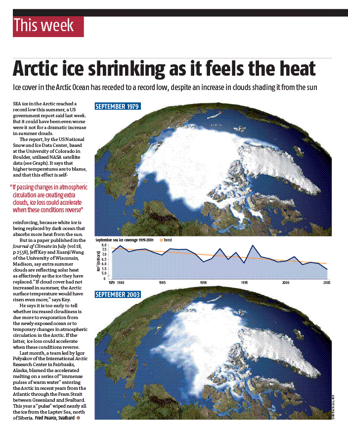
Arctic Sea Ice Reduction in the
Press: Recently published results by X. Wang (Cooperative
Institute for Meteorological Satellite Studies; CIMSS) and J.
Key (NESDIS) were cited in an article titled "Arctic ice shrinking as
it feels the heat" published in the October 8, 2005 issue of New Scientist
magazine (http://newscientist.com, subscription required.
The article is available at http://stratus.ssec.wisc.edu/misc/newscientist_ice_100805.gif).
The National Snow and Ice Data Center recently reported that
sea ice extent in the Arctic was at a record low this past summer. Even
so, results by Wang and Key show that increased summertime cloud cover
over the last decade may actually be moderating the higher temperatures
responsible for the record minimum ice extent. (J. Key, E/RA2,
608-263-2605, jeff.key@noaa.gov)
ITEMS
FOR THE ADMINISTRATOR:
ITEMS
FOR THE ASSISTANT ADMINISTRATOR:
ITEMS
FOR THE OFFICE DIRECTOR, STAR
International Direct Readout
Meeting:
The International EOS/NPP Direct Readout Meeting 2005 was held in
Benevento, Italy October 3-6, hosted by the Mediterranean Agency for
Remote Sensing and Environmental Control (MARSec). The
meeting focussed on three primary areas relevant to the Earth
Observing
System (EOS) satellite and the NPOESS Preparatory Project
(NPP): direct readout application algorithms, direct readout
systems, and upcoming continuity missions. It is
sponsored
by NASA, the Integrated Program Office, NOAA, MARSec, the
University of Wisconsin, and the Province of Benevento. J.
Key (NESDIS), L. Gumley, K.
Strabala,
A. Huang, D. Santek, and T. Achtor (Cooperative Institute for
Meteorological Satellite Studies, CIMSS) attended and gave
presentations. L. Gumley was a co-organizer of the meeting.
(J. Key, E/RA2,
608-263-2605, jeff.key@noaa.gov)
ITEMS
FOR THE DIVISION CHIEF, CoRP
Jun
Li Visits EUMETSAT: Under support of Meteosat Third
Generation
(MTG) program, Jun Li (Cooperative Institute for Meteorological
Satellite Studies, CIMSS) visited the European Organisation for the
Exploitation of Meteorological Satellites (EUMETSAT)
from September 26 to October 7. J. Li collaborated with
EUMETSAT scientists on geostationary satellite advanced IR sounder
spectral coverage using both a retrieval simulation method and
information content analysis. He gave a talk on the subject,
and attended the MTG review meeting held at the EUMETSAT
Headquarters, October 6-7. He also gave a
presentation entitled "CIMSS instrument study of Hyperspectral
Environmental Suite (HES) on GOES-R" where he discussed Hyperspectral
Environmental Suite (HES) spectral resolution, spatial resolution,
temporal resolution, signal-to-noise ratio, spectral coverage, detector
optical ensquared energy (DOEE), etc. This activity is part of the
NOAA/NESDIS ongoing scientific collaboration with the Met Division of
EUMETSAT. (J. Li, CIMSS, 608-262-3755)
AVHRR Calibration Verification
Results Provided to NASA: Bill Rossow of NASA
recently extended the International Satellite Cloud Climatology Project
(ISCCP) past 2001. This extension required a switch from
using the NOAA-14 Advanced Very High Resolution Radiometer (AVHRR) to
the NOAA-16 AVHRR as the reference satellite. He and his
colleagues noticed that the ISCCP cloud amounts increased when the
switch from NOAA-14 to NOAA-16 was made and it was suggested that a
calibration difference between NOAA-14 and NOAA-16 was the source of
the suspicious increase. Because NOAA-14 and NOAA-16 data exist
concurrently in 2001, it was possible to study data from simultaneous
nadir overpasses (SNO). This analysis indicated that the two
satellites observations were in agreement and therefore ruled out a
calibration error as the source of the ISCCP discrepancy. (A.
Heidinger, E/RA2, 608-263-6757. Andrew.Heidinger@noaa.gov, M. Pavolonis, E/RA2,
608-263-9597, mpav@ssec.wisc.edu)
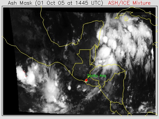
New Technique Used to Identify
Santa Ana, El Salvador Volcanic Cloud: The
October 1, 2005 eruption of the Santa Ana volcano in El Salvador was
successfully identified in GOES-12 imagery by a new automated four
channel technique developed at the Cooperative Institute for
Meteorological Satellite Studies (CIMSS). The volcanic cloud
and neighboring thunderstorms appeared very similar in the visible and
infrared imagery. Under these difficult conditions, the four channel
volcanic ash mask would be useful for real-time volcanic hazard
assessments. (M. Pavolonis, E/RA2, 608-263-9597,
mike.pavolonis@noaa.gov)
 (Click image to enlarge)
Figure caption: An example of a new four channel volcanic ash mask,
which is shown in red and overlaid on a GOES-12 infrared image,
capturing the October 1, 2005 eruption of Santa Ana, El Salvador.
Seminar by Visiting Scientist on
Korean Meteorological Administration Geostationary Satellite Program:
O-Ung Kwon, a visiting scientist from the Korean Meteorological
Administration (KMA), gave a presentation in Madison, Wisconsin on "The
KMA
and Geostationary satellite series COMS." COMS
(Communication, Ocean & Meteorological Satellite) and will have
many uses. It will carry the world’s first
geostationary ocean
color sensor. The satellite is slated for launch in the end of 2008.
(T. Schmit, E/RA2,
608-263-0291, tim.j.schmit@noaa.gov)
Other Meetings and Telecons:
(None)
VISITORS:
NEXT WEEK:
LOOKING AHEAD:
Archived Weeklies Page