[ Archive ]
| CIMSS-NOAA Weekly Report
[ Archive ] |
IN THE PRESS:
ITEMS FOR THE ADMINISTRATOR:
ITEMS FOR THE ASSISTANT ADMINISTRATOR:
ITEMS FOR THE OFFICE DIRECTOR, STAR:
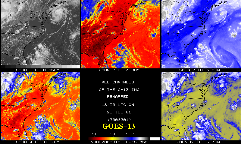
GOES-13 Imager Infrared Data:
The first calibrated infrared data that was taken on July 20, 2006 from
the Geostationary Operational Environmental Satellite (GOES)-13 Imager
were investigated. A Powerpoint presentation on the first GOES-13
Imager infrared images is available at http://rammb.cira.colostate.edu/projects/goes_n.
Preliminary investigations show the data to be comparable favorably
with data from the other GOES imagers. The data were acquired by the
Space Science and Engineering Center (SSEC) Data Center. (T. Schmit,
E/RA2, 608-263-0291, tim.j.schmit@noaa.gov)
 (Click
image to enlarge)
(Click
image to enlarge)
Figure caption: GOES-13 and GOES-12 Imager radiance images from July 12th, 2006 (animation).
Satellite-Derived Products Support National Hurricane Center Hurricane Daniel Analysis:
Satellite products developed at the Cooperative Institute for
Meteorological Satellite Studies (CIMSS) are commonly used in hurricane
analysis. Last week, two of the CIMSS products figured
prominantly in the discussion of Hurricane Daniel at the National
Weather Service's National Hurricane Center (see discussion
below), the Advanced Dvorak Technique (ADT) and the Advanced
Microwave Sounding Unit (AMSU) intensity estimates. (C. Velden, CIMSS,
608-262-9168)
HURRICANE DANIEL DISCUSSION NUMBER 13
NWS TPC/NATIONAL HURRICANE CENTER MIAMI FL EP052006
800 PM PDT WED JUL 19 2006
THE LATEST SATELLITE AND MICROWAVE IMAGES SUGGEST THAT DANIEL HAS
NOT FINISHED ITS EYEWALL REPLACEMENT CYCLE. WHILE CONVECTION HAS
BECOME STRONGER IN THE OUTER EYEWALL...THE INNER EYEWALL HAS ALSO
BECOME BETTER-DEFINED DURING THE PAST FEW HOURS. DVORAK ESTIMATES
ARE A LITTLE MORE UNCERTAIN THAN NORMAL BECAUSE OF THE EYEWALL
CYCLE AND CONSEQUENTLY THE INTENSITY IS MORE DIFFICULT TO
ASCERTAIN. THE CURRENT INTENSITY ESTIMATE OF 95 KT IS BASED ON
SUBJECTIVE DVORAK INTENSITIES OF 90 KT FROM ALL AGENCIES...A CIMSS
AMSU ESTIMATE OF 101 KT AT 2100 UTC AND ADT ESTIMATES OF T5.7...104
KT...DURING THE PAST THREE HOURS.
ITEMS FOR THE DIVISION CHIEF, CoRP
Interview on the Value of GOES Data and Products: T. Schmit was interviewed by two economists from Centric Consulting Group, contracted by the National Climatic Data Center, who are trying to estimate the economic and social value of selected data and products from the Geostationary Operational Environmental Satellites (GOES). This includes both current and next-generation instruments. A number of Powerpoint presentations, web links, reference lists, and other information that covered a range of topics (aviation, biomass burning (from E. Prins), hurricanes, air quality, imager products, sounder products, etc.) were provided to the interviewers. (T. Schmit, E/RA2, 608-263-0291, tim.j.schmit@noaa.gov)
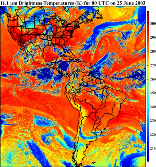
WRF Used for Simulated Data to Test GOES-R Algorithms: The Weather Research and Forecasting (WRF) model was used to generate a simulated atmospheric profile dataset, which provided the necessary input profiles for the Geostationary Imaging Fourier Transform Spectrometer (GIFTS) forward radiative transfer model to generate simulated top of atmosphere (TOA) radiances. The resultant proxy datasets will be used to test various GOES-R science algorithms. The figure below shows the simulated 11.1 micron TOA brightness temperatures from the forward model valid at 00 UTC on 25 June 2003. (J. Otkin, CIMSS, 608-265-2476, E. Olson, CIMSS)
 (Click image to enlarge)
Manuscript on Low Level Cloud Detection Technique Submitted: A manuscript entitled, "A Multi-spectral technique for detecting low level cloudiness" by A.J. Schreiner, S.A. Ackerman, A.K. Heidinger, and B.A. Baum was submitted to the Journal of Atmospheric and Oceanic Technology as a note. The manuscript focuses on a technique that uses Geostationary Operational Environmental Satellite (GOES) Sounder radiance data to detect low-level cloudiness immediately following sunrise. The current cloud mask used at the Cooperative Institute for Meteorological Satellite Studies (CIMSS) frequently misses low level clouds during this time period over the conterminous United States. (T. Schreiner, CIMSS, 608-263-6754, S. Ackerman, CIMSS, 608-263-3647, A. Heidinger, E/RA2, 608-263-6757, andrew.heidinger@noaa.gov, B. Baum, CIMSS, 608-263-3898)
Abstract on GOES-R ABI and the GOES-N Sounder Submitted to 3rd Symposium on NPOESS/GOES-R: An abstract entitled "The GOES-R ABI (Advanced Baseline Imager) and continuation of Geostationary Operational Environmental Satellite(GOES)-N class sounder products", has been submitted to the "Third Symposium on Future National Operational Environmental Satellite Systems—Strengthening Our Understanding of Weather and Climate” to be held in San Antonio, TX, January 14-18, 2007. Coauthors are J. Gurka, J. Li, and K. Schrab (National Weather Service). (T. Schmit, E/RA2, 608-263-0291, tim.j.schmit@noaa.gov)
Other Meetings and Telecons:
(None)
VISITORS:
NEXT WEEK:
LOOKING AHEAD: