 |
CIMSS-NOAA Weekly Report
[ Archive ] |
 |
ASPB AND CIMSS WEEKLY HIGHLIGHTS FOR THE WEEK ENDING SEPTEMBER 22, 2006
IN
THE PRESS:
ITEMS
FOR THE ADMINISTRATOR:
ITEMS FOR THE ASSISTANT ADMINISTRATOR
ITEMS FOR THE OFFICE DIRECTOR, STAR:
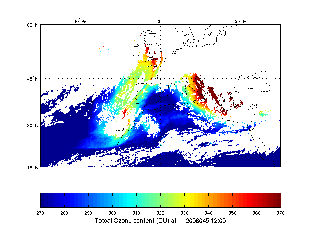
Capability of Geostationary
Imager for Ozone Monitoring Demonstrated by SEVIRI:
The Cooperative Institute for Meteorological Satellite Studies
(CIMSS) GOES (Geostationary Operational Environmental Satellite) team
has developed an algorithm for a total column ozone product from a
geostationary imager such as the Advanced Baseline Imager (ABI) on
GOES-R. Data from the Spinning Enhanced Visible and Infra-Red
Imager (SEVIRI) onboard METEOSAT-8 was used to demonstrate the
capability of a geostationary imager for ozone
moniotring. The total ozone transportation and evolution on
hourly time scale are well depicted. The preliminary SEVIRI
ozone retrievals agree well with ozone measurements from the Ozone
Monitoring Instrument (OMI) onboard the Aura satellite. (Jun Li, CIMSS, Jun.Li@ssec.wisc.edu, 608-262-3755)
 (Click
image to enlarge)
(Click
image to enlarge)
Figure Caption: Total column ozone from SEVIRI on 15 and 16
Feb.2006 (animation).
Direct Broadcast Polar Wind Data Now Delivered to Met Office:
Real-time delivery of direct broadcast polar wind data to the (UK) Met
Office began on September 18, 2006. The Met Office requested wind
data generated with Moderate Resolution Imaging Spectroradiometer
(MODIS) data at direct broadcast sites in Tromsø, Norway and
McMurdo, Antarctica for potential use in their operational forecast
system. The data are delivered in Binary Universal Form for the
Representation of meteorological data (BUFR) format. The U.S.
Navy already receives the data; delivery to EUMETSAT will begin in the
near future. (J. Key, E/RA2,
608-263-2605, jeff.key@noaa.gov;W. Straka III, CIMSS, H. Berger, CIMSS; D. Velden, CIMSS; D. Santek, CIMSS)
ITEMS FOR THE DIVISION CHIEF, CoRP
CGMS Report Contributions: Contributions
to the next Coordination Group for Meteorological Satellites
(CGMS) report were provided to M. Goldberg. T. J. Schmit, P. Menzel, J.
Daniels, J. P. Nelson III wrote a section on NESDIS Geostationary
Operational Environmental Satellite (GOES) soundings. C. Velden, J.
Key, and D. Santek updated a section on NESDIS geostationary and
polar-orbiting winds. (T. Schmit, E/RA2,
608-263-0291, tim.j.schmit@noaa.gov; J. Key, E/RA2,
608-263-2605, jeff.key@noaa.gov)
GOES-10 Super Rapid Scan Imagery:
Geostationary Operational Environmental Satellite (GOES-10) remains in
Super Rapid Scan Operations (SRSO), producing images at 1-minute
intervals. Animations of visible channel imagery showing the
development of severe convection (which produced multiple tornadoes and
large hail) and also water vapor imagery showing an occluding cyclone
are available on the Cooperative Institute for Meteorological Satellite
Studies (CIMSS) Satellite
Blog at http://cimss.ssec.wisc.edu/goes/blog/category/goes-10/.
(S. Bachmeier, CIMSS, 608-263-3958)
Paper on Cloud Height Accepted for Publication:
A paper titled "Cloud Top Height Comparisons from ASTER, MISR, and
MODIS for Trade Wind Cumuli" was accepted in the MISR Special Issue of
Remote Sensing of Environment. Co-authors are Iliana Genkova
(NRC/NOAA-NESDIS Fellow), Gabriela Seiz (MeteoSwiss, Switzerland),
Guangyu Zhao (UIUC), Paquita Zuidema (RSMAS, U of Miami), and Larry Di
Girolamo (UIUC). The paper investigates how two stereo retrieval
techniques compare to a thermal-IR method for deriving cloud top
heights (CTH). Spatial resolution effects are also studied. Authors
conclude that overall, stereo technique appears more suitable for
retrieving CTH for trade wind cumulus clouds than IR-based techniques.
However, since not many spaceborne instruments have stereo
capabilities, it is suggested that IR-derived CTHs should be produced
at the highest possible spatial resolution, with subsampling preferred
over spatial averaging. (I. Genkova, NRC/NOAA-NESDIS Fellow,
608-265-8007)
Other Meetings and Telecons:
(None)
VISITORS:
NEXT WEEK:
LOOKING AHEAD:
Archived Weeklies Page