 |
CIMSS-NOAA Weekly Report
[ Archive ] |
 |
ASPB AND CIMSS WEEKLY HIGHLIGHTS FOR THE WEEK ENDING JANUARY 26, 2007
IN
THE PRESS:
ITEMS
FOR THE ADMINISTRATOR:
ITEMS FOR THE ASSISTANT ADMINISTRATOR:
ITEMS FOR THE OFFICE DIRECTOR, STAR:
Meeting with NOAA Central Library Chief:
During the Annual American Meteorological Society
(AMS) Meeting in San Antonio, TX, Steve Ackerman and Jean Phillips
(Space Science and Engineering Center (SSEC) head Librarian) met with
Doria Grimes, Chief of the NOAA Central Library and discussed potential
collaborations and capabilities. Future collaborations were identified
and will be further explored in the coming year.
(S. Ackerman, CIMSS,
608-263-3647)
Intercalibration Meeting:
Dave Tobin and Mat Gunshor of the Cooperative Institute for
Meteorological Satellite Studies (CIMSS) attended the first Global
Space-Based Inter-Calibration System (GSICS) meeting of the GSICS
Research Working Group (GRWG-I) January 22-23, 2007, at the NOAA Science
Center in Camp Springs, Maryland. Tobin and Gunshor presented
summaries of intercalibration work done at CIMSS over the past decade
covering a wide-range of satellite-to-satellite intercalibration,
aircraft-based validation, and ground-based validation of satellite
instrument calibration. Recommendations were made to the international
GSICS council on how to proceed with coordinated efforts to
intercalibrate the world's geostationary imagers using polar-orbiting
high spectral resolution instruments such as the Atmospheric InfraRed
Sounder (AIRS) onboard Aqua and eventually the Infrared Atmospheric
Sounding Interferometer (IASI) onboard MetOp-A. (M. Gunshor, CIMSS,
608-263-1146; D. Tobin, CIMSS)
ITEMS FOR THE DIVISION CHIEF, CoRP:
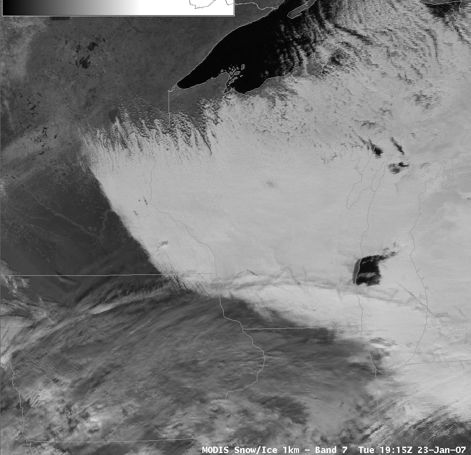
MODIS Imagery in AWIPS Proves Useful:
Training on the use of direct broadcast MODIS imagery in AWIPS, given
recently by scientists from the Cooperative Institute for
Meteorological Satellite Studies (CIMSS) at the NWS office in Sullivan,
Wisconsin, appears to have been successful. One example used in
the training was the MODIS 1 km band 7 imagery (2.1 micron), in which
snow and ice surfaces appear dark compared to water (liquid phase)
clouds. As a result of their training, one of the Sullivan
meteorologists used a band 7 image to determine that one numerical
weather prediction model was performing better than another in the
timing of cloud clearing from the state. This convinced the
forecaster which model would be most helpful in preparing the 24 hour
forecast. The weather discussion issued by the forecaster is
included below. (K. Strabala, CIMSS,
608-263-8752)
AREA FORECAST DISCUSSION
NATIONAL WEATHER SERVICE MILWAUKEE/SULLIVAN WI
324 PM CST TUE JAN 23 2007
.DISCUSSION...FORECAST FOCUS REMAINS ON PCPN CHANCES WITH SERIES OF
DISTURBANCES IN NW FLOW PATTERN.
IN THE SHORT TERM...WATER VAPOR IMAGERY SHOWING DISTINCT SHRT WAVE
AT 20Z JUST NORTH OF LAKE ERIE. SFC TROF REFLECTION OF THIS WAVE
DROPPING THRU CWA ATTM WITH A FEW BANDS OF FLURRIES WHICH SHOULD
EXIT SRN CWA BY 00Z.
BACK EDGE OF LO STRATUS DECK...WHICH SHOWS VERY WELL IN MODIS 1KM
SNOW/ICE IMAGE AT 1915Z...TIMED TO CLEAR MSN AROUND 06Z AND MKE BY
09Z. RUC APPEARS TO HAVE BEST HANDLE ON THIS TREND...WITH CLOUDS
HOLDING TEMPS UP FOR THE EVENING...THEN FALLING OFF RAPIDLY
OVERNIGHT WITH CLEARING SKIES AND FRESH SNOW COVER REACHING MOS LOWS
BY SUNRISE.
 (Click image to enlarge)
Figure caption: MODIS band 7 (near infrared) image from 1915 UTC over Wisconsin on 23
Jaunary 2007. A standard visible image would show both the cloud deck
and the background, which is snow covered, to be white.
Middle School Presentation on Weather Prediction:
R. Aune and R. Holz (Cooperative Institute for Meteorological Satellite
Studies) visited the Sennett Middle School in Madison, Wisconsin, and
gave presentations on observing the atmosphere and predicting its
behavior. The presentations proved to be challenging since the school
follows the "House" program that includes a multi-grade structure in
each classroom; in this case grades six through eight. The lecture
emphasized the role of satellites in observing the atmosphere and
predicting hazardous weather. (R. Aune, E/RA2,
608-262-1071, robert.aune@noaa.gov; R. Holz, CIMSS, 608-263-2566)
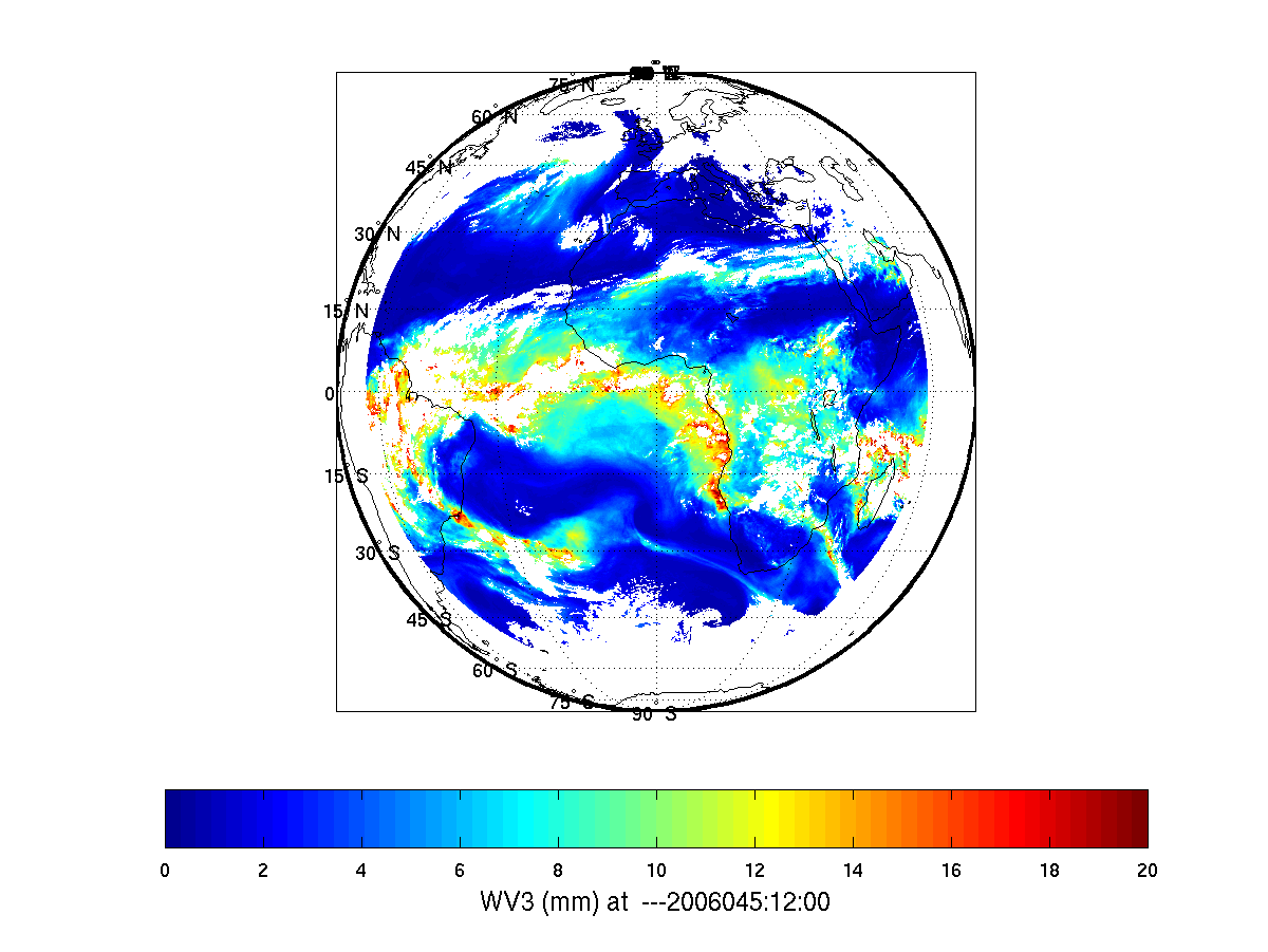
Moisture Evolution with Geostationary Imager:
Evolution of column water vapor can be monitored by geostationary
imager infrared (IR) data with high spatial and temporal
resolutions. SEVIRI (Spinning Enhanced Visible and Infra-Red
Imager) data from Meteosat-8 has been used to demonstrate the
evolution. The loop below shows the column water vapor (mm) in
the 300-700 hPa layer derived from SEVIRI IR spectral bands.
Loops of total precipitable water (TPW) and column water vapor from
three layers (900 hPa - surface, 700 - 900 hPa, and 300 - 700 hPa)
were sent to Dr. Johannes Schmetz, Head of Meteorological Division
at EUMETSAT for collaboration on geostationary imager data process and
applications. (J. Li, CIMSS, 608-262-3755)
 (Click image to enlarge animation)
Figure Caption: Animation of the column water vapor (mm) for the layer 300-700 hPa derived from SEVIRI IR spectral bands.
ABI Conference Abstract Submitted:
An abstract entitled "The ABI (Advanced Baseline Imager) on
Geostationary Operational Environmental Satellite (GOES)-R" was
submitted for the Joint 2007 EUropean organization for the exploitation
of
METeorological SATellites (EUMETSAT) Meteorological Satellite
Conference and the 15th American Meteorological Society (AMS) Satellite
Meteorology and Oceanography Conference to be held in Amsterdam, The
Netherlands, 24-28 September 2007. The authors are Timothy J. Schmit,
James J. Gurka, Mathew M. Gunshor, Jun Li, and W. Paul
Menzel. Note that abstracts for this conference have a hard
deadline of January 31. (T.
Schmit, E/RA2,
608-263-0291, tim.j.schmit@noaa.gov)
Other Meetings and Telecons:
None.
VISITORS:
NEXT WEEK:
LOOKING AHEAD:
Archived Weeklies Page