
[ Archive ]

|
ASPB and CIMSS Weekly Report
[ Archive ] |
|
IN THE PRESS:
ITEMS FOR THE ADMINISTRATOR:
ITEMS FOR THE ASSISTANT ADMINISTRATOR:
ITEMS FOR THE OFFICE DIRECTOR, STAR:
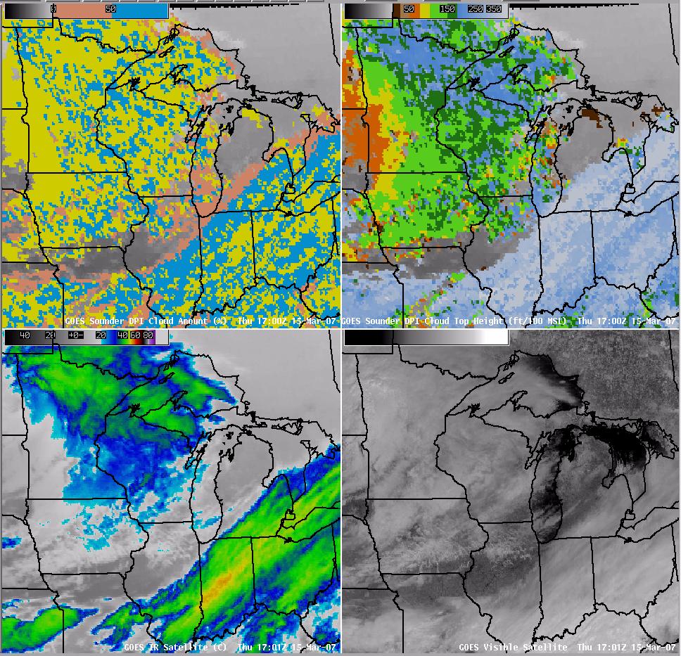
The Effective Cloud Amount DPI from GOES Sounder now part of the AWIPS Suite of Products: The
Effective Cloud Amount (ECA) Derived Product Image (DPI) based on the
Geostationary Operational Environmental Satellite (GOES) Sounder is now part of the Automated Weather Interactive Processing
System (AWIPS) suite of products. The ECA DPI was officially
incorporated into the AWIPS on 5 March 2007 following a request by the
National Weather Service. This GOES Sounder derived product can be used
for comparisons with the numerical model forecast of Sky Cover or as a
potential aide in assisting in max/min temperature forecasts. (J.
Daniels, E/RA2, 301-763-8204, Jaime.Daniels@noaa.gov, J. Gerth, CIMSS,
608-263-4942, S. Bachmeier, CIMSS, 608-263-3958, T. Schreiner, CIMSS,
608-263-6754)
 (Click image to enlarge)
Figure
caption: This figure shows a comparison of GOES Sounder DPI of
Effective Cloud Amount (upper left in Per Cent) and Cloud Top Pressure
(upper right in feet/100 above MSL). GOES Imager IR Window (lower left
in Degrees Celsius) and Visible (lower right) are also shown for 15
March 2007 at 1700 UTC over the Upper Midwest. The yellow color in the
ECA image (upper left) represents 100% or overcast.
Great Alaska Weather Modeling Symposium: R.
Aune gave a presentation titled " Modeling Arctic Clouds and
Precipitation using MODIS" at the first Great Alaska Weather Modeling
Symposium (GAWMS) in Fairbanks, Alaska. He illustrated how forecast
satellite imagery, generated from forecast model output, can be used to
validate and tune model physics and dynamics. Forecast
imagery from the CIMSS Regional Assimilation System (CRAS), Arctic
forecast domain, was compared to 11 micron and 6.7 micron imagery from the Moderate
Resolution Infrared Spectroradiometer (MODIS) to assess the accuracy of
the forecast. It was also demonstrated how MODIS cloud and water vapor
products can be used to initialize a local mesoscale forecast model.
(R. Aune, E/RA2, 608-263-1071, robert.aune@noaa.gov)
OSDPD Hosts CLAVR-x Products On-line: The NOAA/NESDIS Office of Satellite Data Processing and Distribution (OSDPD) recently made public a web-site (http://www.ssd.noaa.gov/PS/CLAVRXGRIDCELL/) showing real-time
products from the Clouds from Advanced Very High Resolution Radiometer
Extended (CLAVR-x) system. The website is based on the site running at
the Cooperative Institute for Meteorological Satellite Studies (CIMSS)
and represents the first public display of CLAVR-x results by OSDPD.
Plans are underway for OSDPD to host high resolution cloud product
images. (A. Heidinger, E/RA2, 608-263-6757, andrew.heidinger@noaa.gov)
ITEMS FOR THE DIVISION CHIEF, CoRP:
Satellite Applications Meeting at La Crosse NWS Office: Following a January 2007 meeting at the Milwaukee/Sullivan(WI) National Weather Service (NWS) Forecast Office, where recent provision of varied experimental satellite products from the Cooperative Institute for Meteorological Satellite Studies (CIMSS) into the NWS Advanced Weather Interactive Processing System (AWIPS) environment at the Sullivan office were discusssed, the CIMSS/ASPB team (of R. Aune, S. Bachmeier, W. Feltz, J. Gerth, K. Strabala, and G. S. Wade) continued the collaborative effort to promote increased use of satellite data and products, visiting the La Crosse (WI) NWS Forecast Office on Tuesday (06 Mar 2007). Educational presentations were given on a number of CIMSS satellite products, including imagery and/or other data from (1) the Moderate Resolution Imaging Spectroradiometer (MODIS), (2) the CIMSS Regional Assimilation System (CRAS) forecast model, (3) the Satellite-based Nowcasting and Aviation Application Program (SNAAP), and (4) the Geostationary Operational Environmental Satellite (GOES) Sounder; both CRAS and SNAAP products include input data from GOES. From office staff feedback, several satellite focus topics will be pursued, including but not limited to: MODIS vegetative index (for fire weather); model forecast imagery, and its validation; and assessment of very high density mesoscale satellite tracked winds. (G. S. Wade, E/RA2, 608-263-4743; D. A. Baumgardt, NWS-ARX(La Crosse), 608-784-8275)Other Meetings and Telecons:
None.
VISITORS:
NEXT WEEK:
LOOKING AHEAD:
| Archived Weeklies Page | Submit a report item |