
[ Archive ]

|
ASPB and CIMSS Weekly Report
[ Archive ] |
|
IN THE PRESS:
ITEMS FOR THE ADMINISTRATOR:
ITEMS FOR THE ASSISTANT ADMINISTRATOR:
ITEMS FOR THE OFFICE DIRECTOR, STAR:
Experimental Geostationary Convection Nowcasting Products at EUMETSAT: Kris
Bedka (Cooperative Institute for Meteorological Satellite Studies,
CIMSS) recently participated in the the European Organisation for the Exploitation of Meteorological Satellites (EUMETSAT) visiting scientist program
for a two week period, where he worked closely with Marianne Koenig on
convective cloud identification, mesoscale satellite cloud tracking,
and convective initiation (CI) nowcasting. This visit relates to GOES-R
risk reduction activities at CIMSS, where the potential impact of
Advanced Baseline Imager (ABI) data on convection nowcasting using Meteosat Second Generation (MSG) Spinning Enhanced Visible and Infra-red Imager (SEVIRI) as a proxy dataset is being evaluated. Dr. Koenig and her staff
were left with a functional set of experimental convection analysis
software tools recently developed at CIMSS. A seminar titled
"Geostationary Convective Storm Diagnostic and Nowcasting Products:
Applications With GOES-12 and MSG" was also given to EUMETSAT
scientists. (K. Bedka, CIMSS, 608-265-0854, W. Feltz, CIMSS,
608-265-6283)
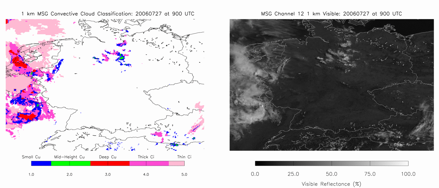 (Click image to enlarge)
Figure
caption: Animation of convective cloud classification over Germany at 1
km resolution using broadband visible and multispectral IR imagery.
Validation of METEOSAT-9 Calibration Accuracy Using AIRS: The
European Organization for the Exploitation of Meteorological Satellites
(EUMETSAT)'s METEOSAT-8, operating at 0 degrees longitude, will be
replaced by METEOSAT-9 on April 11, 2007. Due to a brief malfunction in
METEOSAT-8, METEOSAT-9 was the operational satellite from September 23
- October 10, 2006. Data were collected during this time for comparison
to the polar-orbiting, high spectral resolution, Atmospheric InfraRed
Sounder (AIRS). Preliminary results, based on a relatively small sample
size, showed that METEOSAT-9 compared well to AIRS and to METEOSAT-8
(vicariously through AIRS), which bodes well for the generation of
products and the use of those data in numerical weather prediction
(NWP) applications. These results were presented electronically as a
slide show with the international Global Space-Based Inter-Calibration
System (GSICS) committee and can be found here: http://cimss.ssec.wisc.edu/goes/intercal/METEOSAT-9_AIRS_Intercal_03Apr07.pdf (M. Gunshor, CIMSS, 608-263-1146, T. Schmit, E/RA2, 608-263-0291, tim.j.schmit@noaa.gov)
Apparent Cold Bias in the GOES-13 Imager Band 6 (13.3 um): During
the Geostationary Operational Environmental Satellite (GOES)-13
post-science test analysis, comparisons with high-spectral Atmospheric
InfraRed Sounder (AIRS) data show that there appears to be a cold bias
on the order of -2 K in the GOES-13 Imager band 6 (13.3 micrometer).
This may be mitigated via the use of a bias correction. Preliminary
work was also done regarding the shifting of the band Spectral Response
Function (SRF) to reduce the apparent bias. A memo was circulated to
various GOES calibration experts on this issue. (T. Schmit, E/RA2, 608-263-0291, tim.j.schmit@noaa.gov)
ITEMS FOR THE DIVISION CHIEF, CoRP:
GOES-R Algorithm Testbed Developed: The Geostationary Cloud Algorithm Testbed (GEOCAT) was developed to allow for robust testing and development of next generation Geostationary Operational Environmental Satellite (GOES-R) algorithms. GEOCAT provides a straightforward interface to ancillary data, radiative transfer model calculations, and observed radiances from the GOES-imager, Spinning Enhanced Visible and Infrared Imager (SEVIRI), or Multifunctional Transport Satellite (MTSAT)-imager. GEOCAT is being used extensively by the Cloud Application Team of the GOES-R Algorithm Working Group (AWG) for comparing and testing algorithms. GEOCAT-related collaborations with other AWG groups are underway.(M. Pavolonis, E/RA2, 608-263-9597, Mike.Pavolonis@noaa.gov, A. Heidinger, E/RA2, 608-263-6757, andrew.heidinger@noaa.gov)Other Meetings and Telecons:
None.
VISITORS:
NEXT WEEK:
LOOKING AHEAD:
CIMSS Board Meeting Scheduled: The
Cooperative Institute for Meteorological Satellite Studies (CIMSS)
Board of Directors meeting is scheduled for May 8, 2007 at CIMSS in
Madison, WI. (S. Ackerman, CIMSS, 608-263-3647)
| Archived Weeklies Page | Submit a report item |