
[ Archive ]

|
ASPB and CIMSS Weekly Report
[ Archive ] |
|
IN THE PRESS:
ITEMS FOR THE ADMINISTRATOR:
ITEMS FOR THE ASSISTANT ADMINISTRATOR:
ITEMS FOR THE OFFICE DIRECTOR, STAR:
GOES-10 Sounder Support: As part of the Global Earth Observation System of Systems
(GEOSS)-America’s capacity building, the Cooperative Institute for
Meteorological Satellite Studies (CIMSS) delivered processing software
to generate temperature and moisture profiles from Geostationary
Operational Environmental Satellite (GOES)-10 Sounder data to Rodrigo
Souza of Instituto de Pesquisas Espaciais (INPE, Brazil). (Jun Li,
CIMSS, Zhenglong Li, CIMSS, Jim Nelson, CIMSS, T. Schmit, E/RA2,
608-263-0291, tim.j.schmit@noaa.gov)
Panel to Study Options to Ensure the Climate Record from NPOESS and GOES-R: C. Velden (Cooperative Institute for Meteorological Satellite Studies, CIMSS) attended the first panel meeting to study options for ensuring the climate record from NPOESS and GOES-R at the National Academy of Sciences (NAS) Keck Center in Washington D.C. The charge to the Academy panel is to analyze the impact of the changes to the NPOESS and GOES-R programs, and to develop strategies to mitigate these impacts. The meeting focused on getting background information and updates on each program status. A workshop will be help in mid-June to synthesize the potential mitigation strategies. (C. Velden, CIMSS, 608-262-9168)
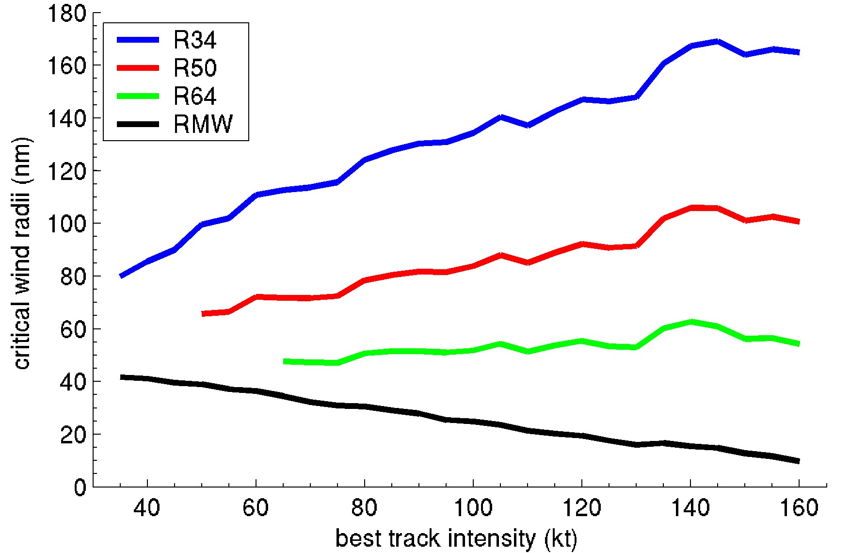
A New Dataset for Estimating Hurricane Size and Structure: One
of the more critical needs of the NOAA National Hurricane Center is
timely operational access to information about the size and structure
of the hurricane wind field. This has always posed a significant
challenge because outer winds are generally estimated from low earth
orbit satellites that are not always available when needed, and
estimating inner winds generally requires aircraft reconnaissance. We recently constructed skillful algorithms that estimate relevant
size and structure parameters using Geostationary Operational
Environmental Satellite (GOES) data. The size and structure parameters
comprise the critical wind radii.
Using a new dataset recently developed in a collaborative effort
between CIMSS and the NOAA National Climatic Data Center, we have now
significantly extended the record of critical wind radii in hurricanes,
covering the period 1983–2005. Response from the NHC forecasters has
been positive. (J. Kossin, CIMSS, 608-265-5356)
 (Click image to enlarge)
Figure caption: An example of a general wind-radii climatology: mean critical wind radii as a function of hurricane intensity. R34, R50, and R64 are the radii of the 34, 50, and 64 knot winds; RMW is the radius of the maximum wind.
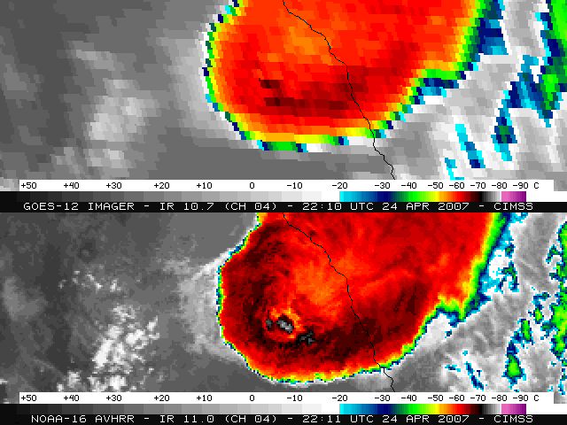
Satellite Imagery From Fatal Tornado Event at Eagle Pass, Texas: Satellite
imagery from the Geostationary Operational Envronmental Satellite
(GOES-12) imager and the NOAA-16 Advanced Very High Resolution
Radiometer (AVHRR) showed the development of severe convection that
produced hail up to 2.75 inches in diameter, wind gusts up to 76 miles
per hour, and the tornado that killed 10 and injured as many as 120
persons in the Eagle Pass, Texas and Piedras Negras, Mexico area on
April 24, 2007. The GOES-12 InfraRed (IR) images showed that these
supercells began to exhibit an “enhanced-v” signature about 30 minutes
prior to the initial storm reports in Texas, and a pronounced anvil
plume was evident on the GOES-12 visible images. A view of the storm
with the 1-km resolution NOAA-16 AVHRR IR image revealed a striking
“warm trench” signature surrounding the most intense overshooting top.
Images and animations are posted on the Cooperative Institute for
Meteorological Satellite Studies (CIMSS) Satellite Blog
(http://tinyurl.com/27an2x). (S. Bachmeier, CIMSS, 608.263.3958)
 (Click image to enlarge)
Figure
caption: Comparison of IR images from GOES-12 (top) and NOAA-16 AVHRR
(bottom), about 2 hours prior to the Eagle Pass, Texas tornado event.
An "enhanced-v" signature is forming on the GOES-12 image, while a
pronounced "warm trench" signature is evident on the NOAA-16 image.
ITEMS FOR THE DIVISION CHIEF, CoRP:
VISIT Activities at CIMSS: Two Virtual Institute for Satellite Integration Training (VISIT) distance learning lessons were conducted during the week by instructors at the Cooperative Institute for Meteorological Satellite Studies (CIMSS). The "Water Vapor Channel Satellite Imagery" session was presented on April 25, with three staff from the Anchorage, Alaska National Weather Service (NWS) forecast office participating. The "Mesoscale Convective Vortices" session was presented on April 26, with eight staff from four NWS forecast offices (Caribou, Maine; Raleigh, North Carolina; Great Falls, Montana; Corpus Christi, Texas) participating. (S. Bachmeier, CIMSS, 608-263-3958, S. Lindstrom, CIMSS)Other Meetings and Telecons:
T. Schmit participated in several telcons, including the Geostationary
Operational Environmental Satellite (GOES) Operational Requirements
Working Group (GORWG), and Geostationary Operational Environmental
Satellite (GOES)-R Atmosphere, Ocean, Land (AOL) Technical Advisory
Panel (TAP) and the fifth GOES Users Conference (GUC) conference
committee meeting.
VISITORS:
NEXT WEEK:
LOOKING AHEAD:
| Archived Weeklies Page | Submit a report item |