 |
ASPB and CIMSS Weekly Report
[ Archive ] |
 |
ASPB AND CIMSS WEEKLY HIGHLIGHTS FOR THE WEEK ENDING MAY 5, 2007
IN THE PRESS:
T. Schmit was interviewed for an article on Geostationary Operational Environmental Satellite (GOES) -R that appeared in Space News (April 16). The headline was "Temperature and Humidity Sensor will not fly on GOES-R". In addition, on May 2, Schmit was also interviewed regarding Geostationary Operational Environmental Satellite (GOES) -R for Weather Brains (an online podcast). (T. Schmit, E/RA2, 608-263-0291, tim.j.schmit@noaa.gov)
ITEMS FOR THE ADMINISTRATOR:
ITEMS FOR THE ASSISTANT ADMINISTRATOR:
ITEMS FOR THE OFFICE DIRECTOR, STAR:
Manuscript on Proxy Dataset Generation Published: A paper entitled "Mesoscale numerical weather prediction models used in support of infrared hyperspectral measurements simulation and product algorithm development" was published in the April issue of the Journal of Atmospheric and Oceanic Technology. The paper by J. Otkin (Cooperative Institute for Meteorological Satellite Studies, CIMSS), D. Posselt (Colorado State University), E. Olson (CIMSS), H.-L. Huang (CIMSS), J. Davies (Division of Marine and Atmospheric Research, CSIRO), J. LI (CIMSS), and C. Velden (CIMSS) describes the methodology used to generate top of atmosphere radiances from high-resolution model output. (J. Otkin, CIMSS, 608-265-2476)
ITEMS FOR THE DIVISION CHIEF, CoRP:
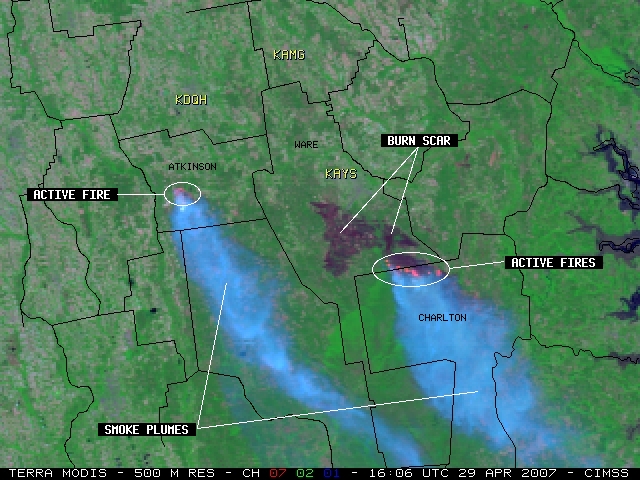
MODIS Image of Georgia Wildfire Burn Scar: A multi-spectral MODerate resolution Imaging Spectroradiometer (MODIS) image from April 29, 2007 showed the large size of the burn scar (over 96,000 acres) from the "Sweat Farm Road / Big Turnaround" fire complex that has been burning for over two weeks south of Waycross (Ware county), Georgia. The active fires that were still burning that day were evident by red-colored "hot spots" along the southeastern edge of the dark-colored burn scar, and the image reveals that the leading edge of the fires had moved southward into extreme northern Charlton county. The image also shows another large fire that had started two days earlier in Atkinson county, which was also exibiting a fire "hot spot" and producing a smoke plume similar in size to that of the Sweat Farm Road fire. Additional MODIS and Geostationary Operational Environmental Satellite (GOES) imagery from these Georgia fires are available on the Cooperative Institute for Meteorological Satellite Studies (CIMSS) Satellite Blog (http://cimss.ssec.wisc.edu/goes/blog). (S. Bachmeier, CIMSS, 608-263-3958)
 (Click image to enlarge)
Figure caption: Multi-spectral MODIS image showing the large burn scar south of Waycross (station
identifier KAYS) in Georgia, along with the location of active fires (red-colored pixels) that were
still burning along the southeastern edge of the burn scar.
Manuscript on Hyperspectral Infrared Surface Emissivity Retrieval Submitted: A manuscript entitled "Physical retrieval of surface emissivity spectrum from hyperspectral infrared radiances" has been submitted to Geophysical Research Letters. Co-authors are Jun Li, Jinlong Li, Elisabeth Weisz (CIMSS) and Daniel K. Zhou (LaRC/NASA) (Jun Li, CIMSS/UW-Madison, 608-262-3755, jun.li@ssec.wisc.edu)
Other Meetings and Telecons:
None.
VISITORS:
NEXT WEEK:
LOOKING AHEAD: