 |
ASPB and CIMSS Weekly Report
[ Archive ] |
 |
ASPB AND CIMSS WEEKLY HIGHLIGHTS FOR THE WEEK ENDING JULY 1, 2007
IN THE PRESS:
ITEMS FOR THE ADMINISTRATOR:
ITEMS FOR THE ASSISTANT ADMINISTRATOR:
ITEMS FOR THE OFFICE DIRECTOR, STAR:
GOES Sounder Talks in San Jose, Costa Rica: T.
Schmit gave a presentation entitled “GOES-10 Sounder Data” on June 26 at
a Geostationary Operational Environmental Satellite (GOES)-10 workshop
in San Jose, Costa Rica. The talk described the GOES-10
Sounder operation and select derived products. In addition, J. Li gave
a talk entitled “GOES infrared sounders - current applications and
future needs” at the 32nd International Symposium on Remote Sensing of
Environment, also held in San Jose. The presentations are available
upon request. (T. Schmit, E/RA2, 608-263-0291, tim.j.schmit@noaa.gov,
J. Li, CIMSS, 608-262-3755)
ITEMS FOR THE DIVISION CHIEF, CoRP:
MODIS Image of Hail Damage Swath in Montana: A long-lived supercell thunderstorm produced large hail (up to 3 inches in diameter) and strong winds (gusting to 89 miles per hour) across portions of northeastern Montana on June 16, 2007. The Cooperative Institute for Meteorological Satellite Studies (CIMSS) received a telephone call on June 26 from the Warning Coordination Meteorologist at the National Weather Service forecast office at Glasgow, Montana to request a special sector of Moderate Resolution Imaging Spectroradiometer (MODIS) true color imagery centered over the resulting hail damage swath, to aid in their post-case analysis. Geostationary Operational Environmental Satellite (GOES) and MODIS imagery from this event were posted on the CIMSS Satellite Blog (http://tinyurl.com/2vhhof). (S. Bachmeier, CIMSS, 608-263-3958, L. Gumley, CIMSS, 608-265-5358)
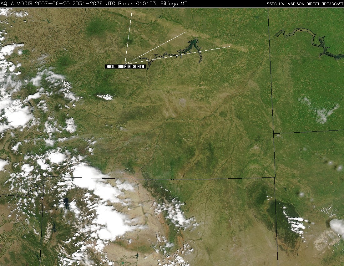 (Click image to enlarge)
Figure caption: Aqua MODIS true color image showing a large hail damage swath across northeastern Montana, 4 days after severe thunderstorms produced large hail and damaging winds over that region.
VISIT Activities at CIMSS: The Virtual Institute for Satellite Integration Training (VISIT) distance learning lessons "Water Vapor Channel Satellite Imagery" and "Mesoscale Convective Vortices" were presented on June 25 and June 28, respectively. Forecasters from NOAA's National Weather Service forecast offices in Spokane, Washington, Lake Charles, Louisiana, and Chicago, Illinois participated in the VISIT lessons. (S. Bachmeier, CIMSS, 608-263-3958, S. Lindstrom, CIMSS, 608-263-4425)
Additional GOES-10 Sounder Data Available via the Web: Additional imagery derived from Geostationary Operational Environmental Satellite (GOES)-10 Sounder radiances is now available via the Web. The imagery shows Total Precipitable Water (TPW) over South America, completely covering the continent every 4 hours, and can be found at: http://cimss.ssec.wisc.edu/goes/rt/goes10.php. This work is being done in support of the Global Earth Observation System of Systems (GEOSS) Americas project. The overall goal of this effort is to demonstrate the GOES-10 imagery available via the Imager and Sounder schedules, and to showcase what is possible with select Sounder products. (J. Nelson, CIMSS, 608-263-6013, T. Schmit, E/RA2, 608-263-0291, tim.j.schmit@noaa.gov)
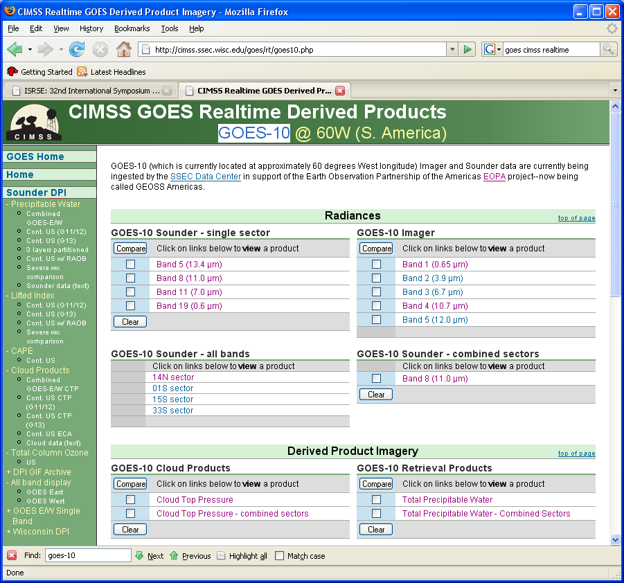 (Click image to enlarge)
Figure caption: CIMSS GOES Realtime Derived Products Web Page for GOES-10 (http://cimss.ssec.wisc.edu/goes/rt/goes10.php)
GOES-13 13.3 micron Band Imager Final Memo: The final version of the GOES-13 Imager 13.3 micron (band 6) cold bias memo has been posted. The statements in the memo are supported by comparisons with high-spectral Atmospheric InfraRed Sounder (AIRS) data, comparisons with broad-band High-resolution Infrared Radiation Sounder (HIRS) data on NOAA-15 and NOAA-16, and a limited number of forward model comparisons. The bias is consistent with a spectral response shift on the order of approximately 4 cm-1. The file is posted at: http://rammb.cira.colostate.edu/projects/goes_n/#analysis. (T. Schmit, E/RA2, 608-263-0291, tim.j.schmit@noaa.gov)
Other Meetings and Telecons:
None.
VISITORS:
NSMC Visitor: Qisong Zhang of the National
Satellite Meteorological Center (NSMC) in Beijing, China, will be
visiting the Cooperative Institute for Meteorological Satellite Studies
(CIMSS) for three months. Mr. Zhang will compare methods of estimating
polar winds from Advanced Very High Resolution Radiometer (AVHRR) data
in preparation for wind retrieval using the imager on the the FengYun-3
(FY-3) satellite. FY-3 will be launched this October. (J. Key, E/RA2,
608-263-2605, jkey@ssec.wisc.edu)
NEXT WEEK:
LOOKING AHEAD: