
[ Archive ]

|
ASPB and CIMSS Weekly Report
[ Archive ] |
|
IN THE PRESS:
ITEMS FOR THE ADMINISTRATOR:
ITEMS FOR THE ASSISTANT ADMINISTRATOR:
ITEMS FOR THE OFFICE DIRECTOR, STAR:
EUMETSAT Polar System Program Scientist Visit: Dr. K. Dieter Klaes, the Program Scientist for the European Organisation for the Exploitation of Meteorological Satellites (EUMETSAT) Polar System (EPS), visited the Cooperative Institute for Meteorological Satellite Studies (CIMSS) August 30-31. The primary purpose of his visit was to discuss the development of a polar wind product using Advanced Very High Resolution Radiometer (AVHRR) data from EUMETSAT's recently launched Metop-A (Meteorological operational Satellite) platform. Dr. Klaes gave a seminar on the status and first results of the EUMETSAT Polar System. (J. Key, E/RA2, 608-263-2605, jkey@ssec.wisc.edu)
ITEMS FOR THE DIVISION CHIEF, CoRP:
Intercalibration Results Presented at SPIE: Results on intercalibration using high spectral resolution Atmospheric InfraRed Sounder (AIRS) data to monitor geostationary imagers on Geostationary Operational Environmental Satellite (GOES)-12 and Meteorological Satellite (METEOSAT)-8 were presented as a poster (with an accompanying paper) at a Society of Photo-optical Instrumentation Engineers (SPIE) conference in San Diego, California 27-28, August 30, 2007. The poster presentation focused on methods of compensating for AIRS spectral gaps in the intercalibration process as well as on the results, which were generally positive for both GOES and METEOSAT. Researchers at the Cooperative Institute for Meteorological Satellite Studies (CIMSS) have been carefully developing the method for intercalibration for approximately ten years and began applying it to AIRS data approximately four years ago. Results have been presented in a variety of conference formats using AIRS to intercalibrate the world's geostationary imagers (from the United States, Europe, China, and Japan), and highlighting improvements to the algorithm such as recent advances in the AIRS gap-filling method. (M. Gunshor, CIMSS, 608-263-1146, T. Schmit, E/RA2, 608-263-0291, tim.j.schmit@noaa.gov, W.P. Menzel, CIMSS, 608-263-4930, D. Tobin, CIMSS, 608-265-6281)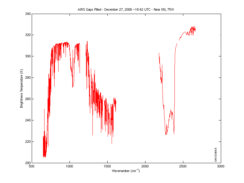 (Click image to enlarge)
 (Click image to enlarge)
Other Meetings and Telecons:
None.
VISITORS:
NEXT WEEK:
LOOKING AHEAD:
| Archived Weeklies Page | Submit a report item |