
[ Archive ]

|
ASPB and CIMSS Weekly Report
[ Archive ] |
|
IN THE PRESS:
ITEMS FOR THE ADMINISTRATOR:
ITEMS FOR THE ASSISTANT ADMINISTRATOR:
ITEMS FOR THE OFFICE DIRECTOR, STAR:
Paper on Satellite-Based Aviation Products Published: A
paper by John Mecikalski and co-authors, entitled "Aviation
Applications for Satellite-Based Observations of Cloud Properties,
Convective Initiation, In-Flight Icing, Turbulence, and Volcanic Ash,"
was published in the Bulletin of the American Meteorological Society
(BAMS). The co-authors include Wayne Feltz, Kris Bedka, Sarah Bedka,
Tony Wimmers (Cooperative Institute for Meteorological Satellite
Studies, CIMSS), and Michael Pavolonis (NOAA/NESDIS/STAR). The article
highlights important research efforts aimed at improving aviation
safety through the use of satellite-derived products. In addition,
content from the article was featured on the cover of the BAMS. (W.
Feltz, CIMSS, 608-265-6283, M. Pavolonis, E/RA2, 608-263-9597,
Mike.Pavolonis@noaa.gov)
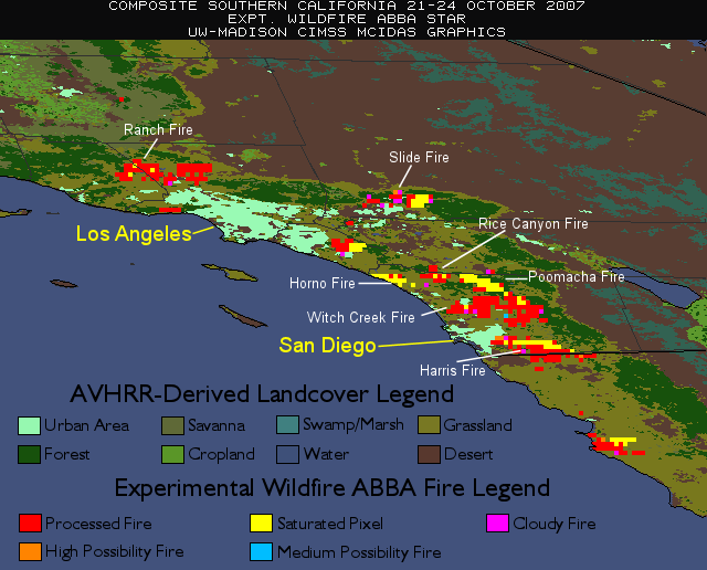
Monitoring Southern California Wildfires with GOES WF_ABBA: Researchers
at the Cooperative Institute for Meteorological Satellite Studies
(CIMSS) have been monitoring the historic wildfires in Southern
California using the Wildfire Automated Biomass Burning Algorithm
(WF_ABBA). By Friday, October 26, nearly 500,000 acres (~780 square
miles) were burned and over 1600 homes were destroyed. Such large-scale
fires have become increasingly common in Southern California in recent
years, two of the more notable cases being the Cedar Fire of October
2003 and the Viejas Wildfire near San Diego in January 2001. The
WF_ABBA provides frequent, low latency detections and characterizations
of fires such as these, as well as the ability to build composites to
show the overall development of the fires. (C. Schmidt, CIMSS,
608-262-7973, J. Brunner, CIMSS, 608-263-3434, E. Prins, CIMSS,
530-271-2256)
 (Click image to enlarge)
Figure
caption: Composite of Geostationary Operational Environmental Satellite
(GOES) Wildfire Automated Biomass Burning Algorithm (WF_ABBA) detected
fires over Southern California for 21-27 October 2007.
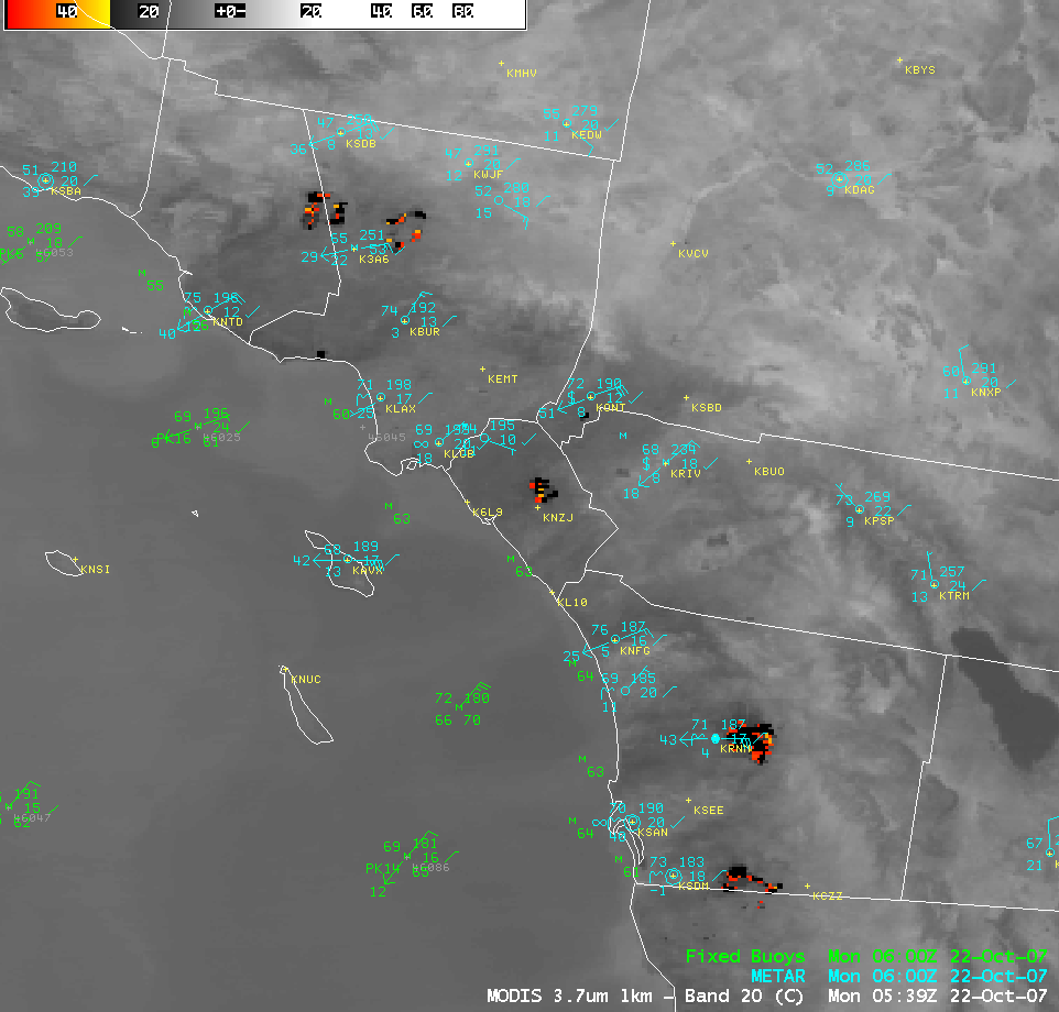
GOES and MODIS images of the Southern California Fires: A
variety of Geostationary Operational Environmental Satellite (GOES) and
Moderate resolution Imaging Spectroradiometer (MODIS) images of the
large fire outbreak in southern California were posted on the
Cooperative Institute for Meteorological Satellite Studies (CIMSS)
Satellite Blog on October 21 (http://tinyurl.com/25j762), October 22 (http://tinyurl.com/2ego89), and October 23 (http://tinyurl.com/27stlz)
2007. Some of the image examples include GOES visible channel
animations showing the smoke transport, a high resolution MODIS true
color image of the smoke, and close-up MODIS and GOES shortwave
InfraRed (IR) images showing the fire hot spots. (S. Bachmeier, CIMSS,
608-263-3958, L. Gumley, CIMSS, 608-265-5358)
 (Click image to enlarge)
Figure
caption: An Advanced Weather Interactive Processing System (AWIPS)
image of the MODIS 3.7 micrometer shortwave InfraRed channel, showing
the "hot spots" associated with large fires burning in southern
California on October 22, 2007.
ITEMS FOR THE DIVISION CHIEF, CoRP:
Manuscript on GOES Sounding Improvement and Applications Submitted: A manuscript entitled "GOES sounding improvement and applications to severe storm nowcasting" has been submitted to Geophysical Research Letters for publication. Co-authors are Zhenglong Li, Jun Li, W. P. Menzel (CIMSS), Tim Schmit (StAR), Jim Nelson (CIMSS), Jaime Daniels (StAR) and Steve Ackerman (CIMSS). This manuscript described the improved GOES (Geostationary Operational Environmental Satellite) Sounder single field-of-view sounding algorithm and the applications of product in super cell storm nowcasting. The improved algorithm has been implemented into the CIMSS merged GOES Sounder real time processing. (Jun Li, CIMSS, 608-262-3755)Other Meetings and Telecons:
None.
VISITORS:
NEXT WEEK:
T. Schmit will give a presentation on “Geostationary Operational Environmental Satellite (GOES) Science/Products Improvements” at the National Oceanic and Atmospheric Administration (NOAA)- EUropean organization for the exploitation of METeorological SATellites (EUMETSAT) Future Geostationary Programs meeting in Suitland, Maryland. Topics to be covered include: GOES 7/8, GOES-12/13 and GOES-R. The presentation is available upon request. The meeting will be October 30. (T. Schmit, E/RA2, 608-263-0291, tim.j.schmit@noaa.gov)
LOOKING AHEAD:
| Archived Weeklies Page | Submit a report item |