 |
ASPB and CIMSS Weekly Report
[ Archive ] |
 |
ASPB AND CIMSS WEEKLY HIGHLIGHTS FOR THE WEEK ENDING NOVEMBER 3, 2007
IN THE PRESS:
ITEMS FOR THE ADMINISTRATOR:
ITEMS FOR THE ASSISTANT ADMINISTRATOR:
ITEMS FOR THE OFFICE DIRECTOR, STAR:
Joint EUMETSAT/NOAA Meeting on Future Systems: T.
Schmit gave a presentation on “Geostationary Operational Environmental
Satellite (GOES) Science/Products Improvements” at the NOAA/EUMETSAT
(EUropean organization for the exploitation of METeorological
SATellites) Future Geostationary Programs meeting. Topics covered
included: GOES 7/8, GOES-12/13 and GOES-R. The presentation is
available upon request. The meeting was held on October 30 at the NSOF
(NOAA Satellite Operations Facility) in Suitland, MD. X. Wu,
NOAA/NESDIS/STAR presented a talk entitled “GOES Calibration
Experiences”. (T. Schmit, E/RA2, 608-263-0291, tim.j.schmit@noaa.gov)
ITEMS FOR THE DIVISION CHIEF, CoRP:
A New Secondary Eyewall Formation Index based on SHIPS Developmental Data: We’re continuing our progress toward an algorithm that will utilize environmental analyses and GOES infrared imagery to objectively diagnose and forecast hurricane secondary eyewall formation. Here we introduce a new algorithm based on environmental parameters from the SHIPS developmental dataset applied to Bayesian methodology. Utilizing this dataset will allow for a very simple merging of our index with the Annular Hurricane Index being developed by our CIRA/NESDIS collaborators, which also uses the SHIPS developmental dataset. (J. Kossin, CIMSS, 608-265-5356, Matthew Sitkowski, CIMSS)
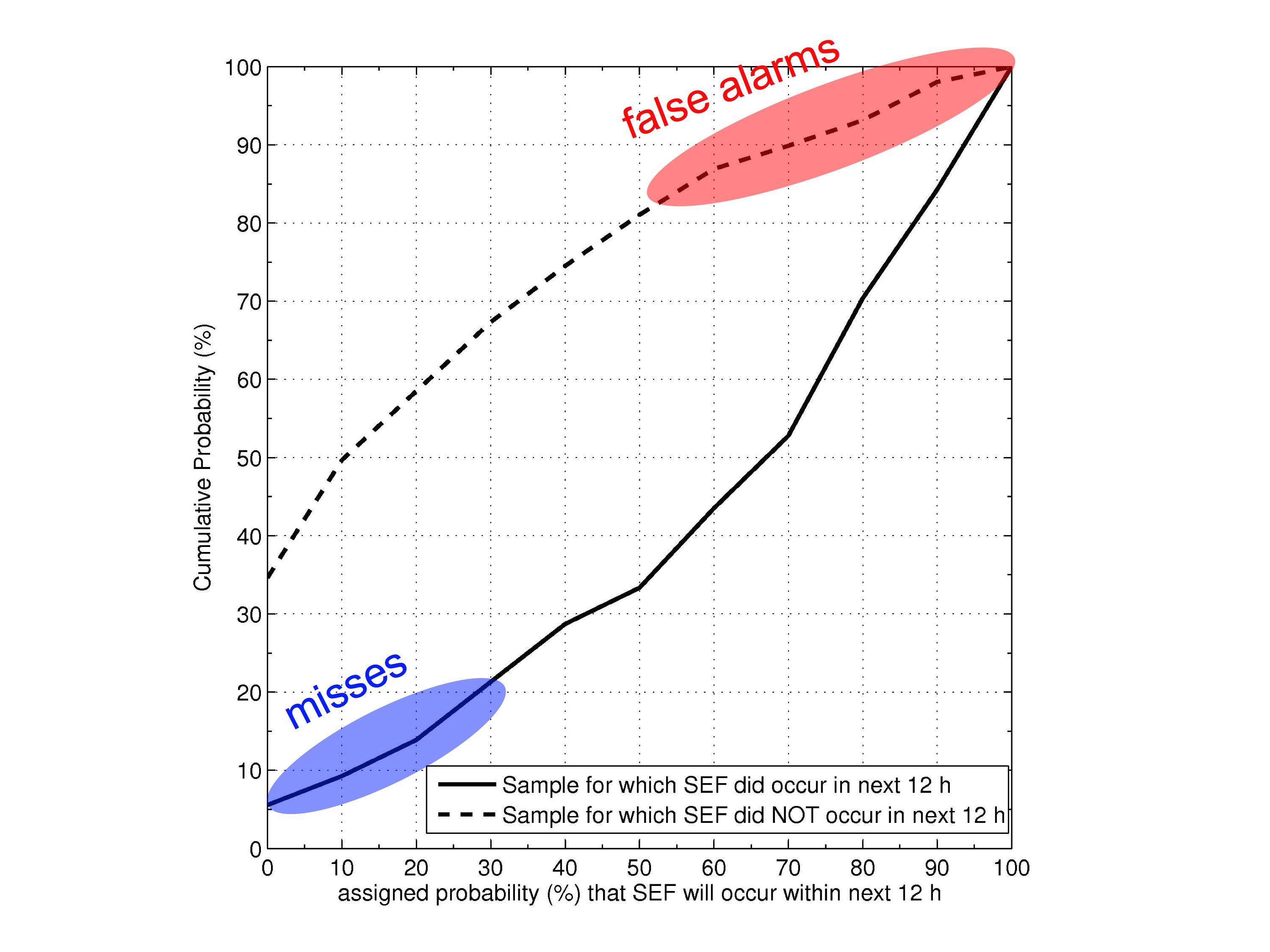 (Click image to enlarge)
Figure caption: Cumulative probability of the probability that secondary eyewall formation (SEF) will occur within the next 12 h, as assigned by our new SHIPS developmental dataset-based algorithm. Solid line: probability of SEF assigned to storms that did undergo SEF. Dashed line: probability of SEF assigned to storms that did not undergo SEF. The algorithm is skillful, assigning higher probability than the climatological probability (of around 30%) in 80% of SEF cases. This is analogous to a success rate of 80%. The algorithm also assigns a probability of SEF that is greater than 50% in about 20% of non-SEF cases. This is a subjective measure of our false-alarm rate.
CIMSS VISIT Activities: The Virtual Institute for Satellite Integration Training (VISIT) distance learning lesson "Trough of Warm Air Aloft (TROWAL) Identification" was given by staff from the Cooperative Institute for Meteorological Satellite Studies (CIMSS) on October 30, 2007, with eight forecasters from three separate National Weather Service (NWS) forecast offices participating (Cheyenne, Wyoming; Lubbock, Texas; Great Falls, Montana). In addition, a new VISIT lesson "Water Vapor Imagery and Potential Vorticity Analysis" (which was developed at CIMSS over the past several months) debuted on October 31, 2007. The initial offering of this new VISIT lesson was well-attended, with 50 National Weather Service (NWS) forecasters participating from 11 separate NWS forecast offices (Anchorage, Alaska; Austin/San Antonio, Texas; Blacksburg, Virginia; Buffalo, New York; Charleston, South Carolina; Charleston, West Virginia; Davenport, Iowa; El Paso, Texas; Gaylord, Michigan; Raleigh, North Carolina; Reno, Nevada). (S. Bachmeier, CIMSS, 608-263-3958, S. Lindstrom, CIMSS, 608-263-4425)
Participation in Environmental Satellite Resource Center Working Group Meeting: S. Bachmeier participated remotely (via GoToMeeting and conference call) in the Environmental Satellite Resource Center (ESRC) Working Group Meeting held in Boulder, Colorado on November 1, 2007. Topics discussed included priorities and recommendations for satellite training resources to include in the ESRC, and roles and responsibilities for the next phases of the effort to implement a working model of the ESRC by May 2008. (S. Bachmeier, CIMSS, 608-263-3958)
New Direct Broadcast MODIS NDVI and LST Products Added to AWIPS Suite for NWS : University of Wisconsin-Madison (UW) MODIS direct broadcast products created for use by the National Weather Service (NWS) now include the Normalized Difference Vegetation Index (NDVI) and Land Surface Temperature (LST) products at 1 km. These two products are created in real-time and injected into the Unidata Local Data Manager (LDM) for use at NWS forecast offices via the Advanced Weather Interactive Processing System (AWIPS). The two new products are expected to aid forecasters with predicting high and low temperatures as well as fire potential and fog formation.
(K. Strabala, CIMSS, 608-263-8752; J. Gerth, CIMSS)
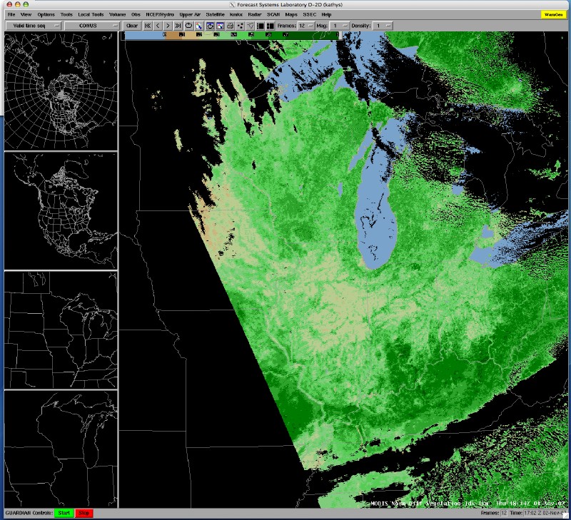 (Click image to enlarge)
Figure caption: Example of the new UW direct broadcast 1 km NDVI MODIS product being created and distributed to the NWS forecast offices for display via AWIPS. This example is from 1 November 2007 18:14 UTC.
Other Meetings and Telecons:
None.
VISITORS:
NEXT WEEK:
J. Key will participate in the International Polar Year workshop on Sustaining Arctic Observing Networks (SAON) in Stockholm, Sweden next week. This workshop, the first of three, will address the question: Are current Arctic observing and data and
information management activities sufficient to meet users’ needs? Additional information is available at http://arcticobserving.org.
(J. Key, E/RA2, 608-263-2605, jkey@ssec.wisc.edu)
LOOKING AHEAD: