
[ Archive ]

|
ASPB and CIMSS Weekly Report
[ Archive ] |
|
IN THE PRESS:
ITEMS FOR THE ADMINISTRATOR:
ITEMS FOR THE ASSISTANT ADMINISTRATOR:
ITEMS FOR THE OFFICE DIRECTOR, STAR:
VISIT/SHyMet Working Group Meeting: A Virtual Institute for Satellite Integration Training (VISIT) /
Satellite Hydrology and Meteorology (SHyMet) working group meeting
was hosted by the Cooperative Institute for Meteorological Satellite
Studies (CIMSS) on November 6-7, 2007. Visiting participants included
members of the National Weather Service (NWS), the Geostationary
Operational Environmental Satellite (GOES)-R Program Office, and the
Cooperative Institute for Research in the Atmosphere (CIRA). The
meeting reviewed the current status of the VISIT and SHyMet distance
learning programs, and also outlined additional plans and activities
for Fiscal Year 2008. As a part of the meeting agenda, demonstrations
were given of the NWS Advanced Weather Interactive Processing
System (AWIPS) workstation capabilities, as implemented at CIMSS, that
support VISIT/SHyMet and other "satellite proving ground" activities.
(S. Bachmeier, CIMSS, 608-263-3958; R. Aune, E/RA24, 608-262-1071;
G.S. Wade, E/RA24, 608-263-4743)
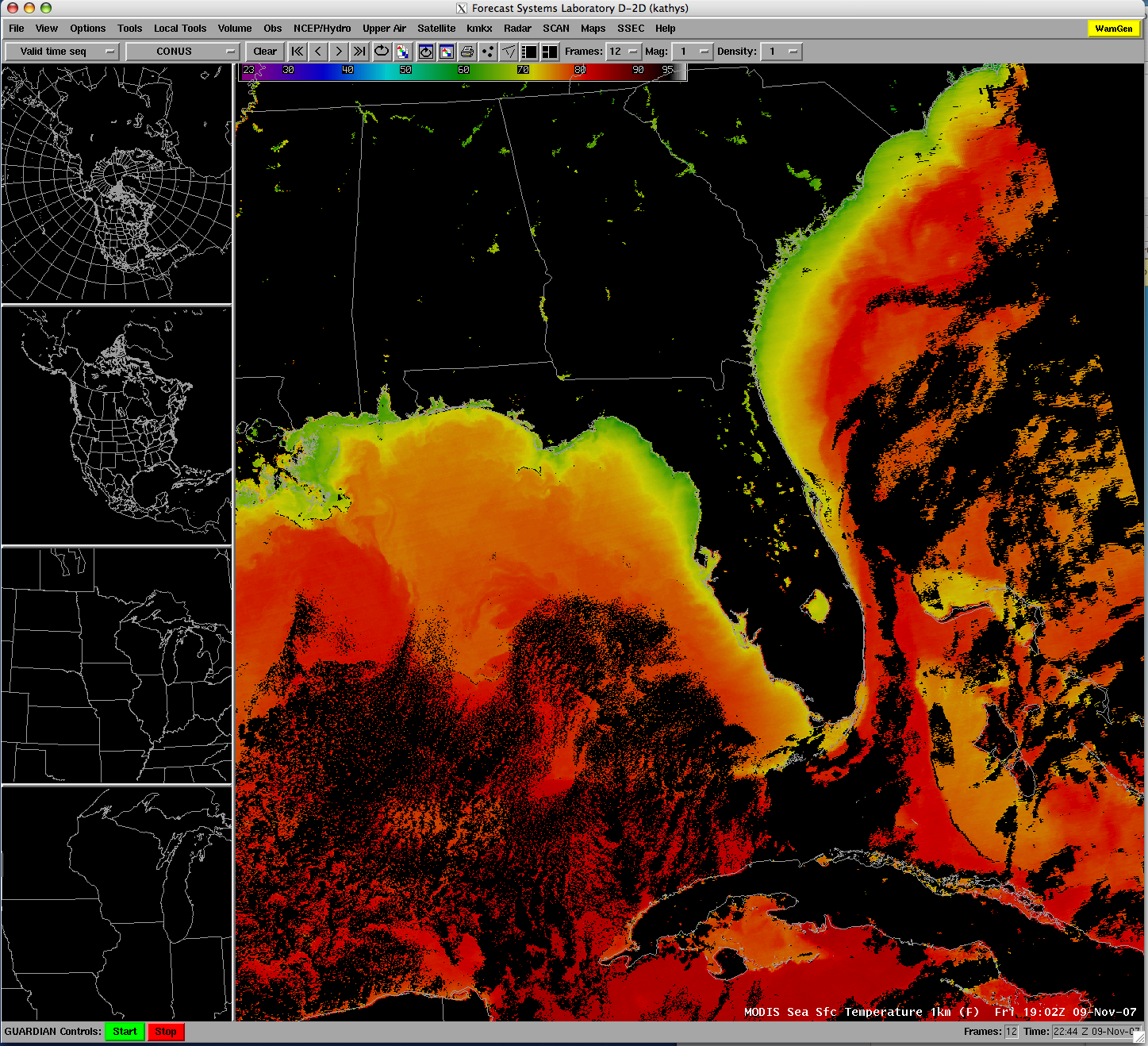
CIMSS MODIS Direct Broadcast Products used by NASA Space Shuttle Forecasters: High
resolution direct broadcast MODIS 1km Sea Surface Temperatures (SST)
created in near real-time at the University of Wisconsin-Madison (UW)
were used to help NASA meteorologists in forecasting sky conditions for
the take-off and landing of the recent space shuttle Discovery mission.
The 1km SST product is part of a suite of products that are created at
the CIMSS and distributed through the Local Data Manager (LDM) for
visualization via (Advanced Weather Interactive Processing System)
AWIPS, a visualization tool that is used by both NASA and NOAA National
Weather Service (NWS) forecasters. (K. Strabala, CIMSS, 608-263-8752,
S. Bachmeier, CIMSS, 608-263-3958, J. Gerth, CIMSS)
 (Click image to enlarge)
Figure
caption: Example of a the MODIS 1km SST product created from direct
broadcast UW CIMSS data and provided to forecasters via AWIPS.
ITEMS FOR THE DIVISION CHIEF, CoRP:
Satellite Measurements and Great Lakes Air Quality Forecasting: A meeting with members of the Wisconsin Department of Natural Resources (WDNR) air quality forecasting team was held at WDNR headquarters to discuss possible WDNR/NESDIS collaborative activities in support of Great Lakes regional air quality forecasting and assessment activities. (R. B. Pierce, E/RA2, 608-890-1892, brad.pierce@noaa.gov)Other Meetings and Telecons:
None.
VISITORS:
NEXT WEEK:
LOOKING AHEAD:
| Archived Weeklies Page | Submit a report item |