 |
ASPB and CIMSS Weekly Report
[ Archive ] |
 |
ASPB AND CIMSS WEEKLY HIGHLIGHTS FOR THE WEEK ENDING JANUARY 19, 2008
IN THE PRESS:
ITEMS FOR THE ADMINISTRATOR:
ITEMS FOR THE ASSISTANT ADMINISTRATOR:
ITEMS FOR THE OFFICE DIRECTOR, STAR:
ITEMS FOR THE DIVISION CHIEF, CoRP:
CIMSS VISIT Activities: The Virtual Institute for Satellite Integration Training (VISIT) distance learning lessons "Trough of Warm Air Aloft (TROWAL) Identification" and "Water Vapor Imagery and Potential Vorticity Analysis" were led by staff from the Cooperative Institute for Meteorological Satellite Studies (CIMSS) on January 9 and 18, respectively. Forecasters from four separate National Weather Service (NWS) forecast offices (Buffalo, New York; Gaylord, Michigan; Minneapolis, Minnesota; Riverton, Wyoming) participated in the VISIT lessons. (S. Bachmeier, CIMSS, 608-263-3958, S. Lindstrom, CIMSS, 608-263-4425)
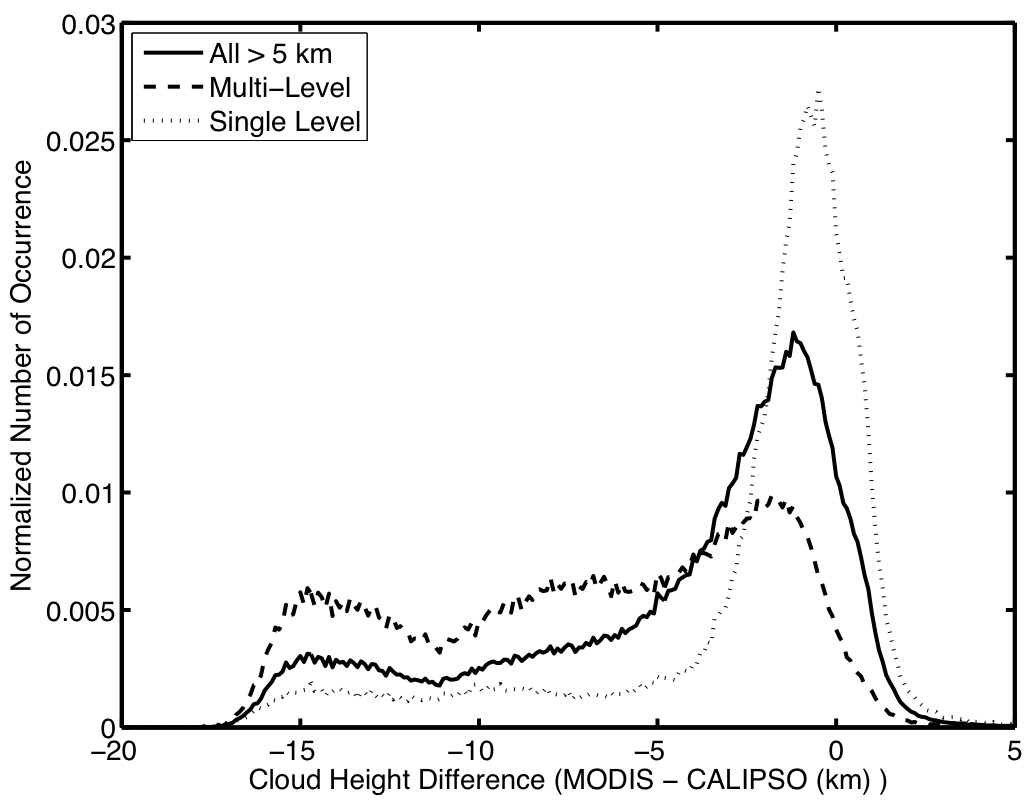
CALIOP and MODIS Cloud Detection and Height Comparison: A detailed comparison between Cloud-Aerosol Lidar with Orthogonal Polarization (CALIOP) and the Moderate Resolution Imaging Spectroradiometer (MODIS) for both cloud detection and cloud top height (CTH) retrievals has been completed and a paper submitted to a special issue of the Journal of Geophysical Research. For scenes when MODIS successfully applies CO2 slicing, the distribution becomes considerably narrower, almost eliminating the very large negative CTH biases found in the distribution containing all MODIS CTH retrievals (window brightness temperature (BT) and CO2 slicing). For scenes determined by CALIOP to include single-layer clouds, the MODIS CO2 slicing histogram is narrower than both the combined and CO2-slicing-only results and agrees with the expected biases resulting from the physical sensitivity differences between a passive IR-based and active sensor CTH retrieval. (R. Holz, CIMSS, 608-263-2566)
 (Click image to enlarge)
Figure caption: Histogram of the global cloud height differences during August 2006 for CALIOP-determined high clouds (> 5km) filtered for cases where the MODIS retrieval applied CO2 slicing (solid line) and CALIOP determined single level clouds (dotted line). The distribution for all high clouds (combined CO2 slicing and window BT retrieval) is also shown.
GOES-R Poster Reviews: As the poster
co-chair, Tim Schmit reviewed over 60 posters relating to Geostationary
Operational Environmental Satellite (GOES)-R. This is for the 5th GOES
Users' Conference. (T. Schmit, E/RA2, 608-263-0291,
tim.j.schmit@noaa.gov)
Other Meetings and Telecons:
- Geostationary Operational Environmental Satellite (GOES) Users'
Conference program committee (Schmit)
- GOES Operational Requirements Working
Group (GORWG) (Schmit)
- GOES-R Senior Science Staff meeting (Schmit)
VISITORS:
NEXT WEEK:
The 5th Geostationary Operational Environmental Satellite (GOES) Users'
Conference will be held as part of the American Meteorological Society's (AMS) Annual Meeting in New Orleans, LA, next week. Many CIMSS and ASPB staff will attend. T. Schmit will present “The ABI (Advanced Baseline Imager) on the
GOES-R series” and “GOES-10 @ 60 West – A Wisconsin Perspective". Additional meetings of interest include the AMS Satellite Committee meeting and the Global Earth Observation System
of Systems (GEOSS) in the Americas Integrate Satellite Capacity
Building and Training Workshop Planning Meeting. (T. Schmit, E/RA2,
608-263-0291, tim.j.schmit@noaa.gov)
LOOKING AHEAD: