
[ Archive ]

|
ASPB and CIMSS Weekly Report
[ Archive ] |
|
IN THE PRESS:
ITEMS FOR THE ADMINISTRATOR:
ITEMS FOR THE ASSISTANT ADMINISTRATOR:
ITEMS FOR THE OFFICE DIRECTOR, STAR:
Visitor from Kazakhstan: Irina Kalyamova from the Hydrometeorological Monitoring Centre of Astana, Kazakhstan spent two months at the Cooperative Institute for Meteorological Satellite Studies (CIMSS) investigating how to utilize satellite remote sensing data for improved environmental services in her country. During her stay she became familiar with McIDAS and HYDRA (HYperspectral-viewer for Development of Research Applications) data visualization capabilities, investigated opportunities for the Moderate Resolution Imaging Spectroradiometer (MODIS) to fill in data voids, started local tuning of the MODIS-derived temperature and moisture profiles, and coordinated a demonstration of regional forecast improvements realized in the CIMSS Regional Assimilation System (CRAS) by inclusion of MODIS radiances and winds. The goal of her work is to provide forecasters in Astana with weather maps of temperature and moisture that supplement the 250 points of ground observations and the 8 radiosonde stations covering the 2.7 million square kilometer area. At the conclusion of her stay in mid January, she gave a presentation on weather forecasting in Kazakhstan – present situation and future plans. (Paul Menzel, CIMSS, 608-263-4930)
Manuscript on Ozone retrieval from ABI/SEVIRI Published: A
manuscript entitled "Retrieval of Total Column Ozone From Imagers
Onboard Geostationary Satellites" has been published in IEEE
Transactions on Geoscience and Remote Sensing (Vol. 46, 2008, P.
479-488). The co-authors are Xin Jin, Jun Li, Chris Schmit (CIMSS), Tim
Schmit (STAR) and Jinlong Li (CIMSS). This paper summarizes the ozone
algorithm for Advanced Baseline Imager (ABI) and Spinning Enhanced
Visible and
InfraRed Imager (SEVIRI), and demonstrates how well geostationary
imagers can capture ozone transport and change with high temporal and
spatial resolutions. The estimated total column ozone (TCO) from SEVIRI
has very good agreement with the total ozone measurements from the Ozone Monitoring Instrument
(OMI) onboard the Earth Observing System Aura platform. (Jun Li, CIMSS,
608-262-3755)
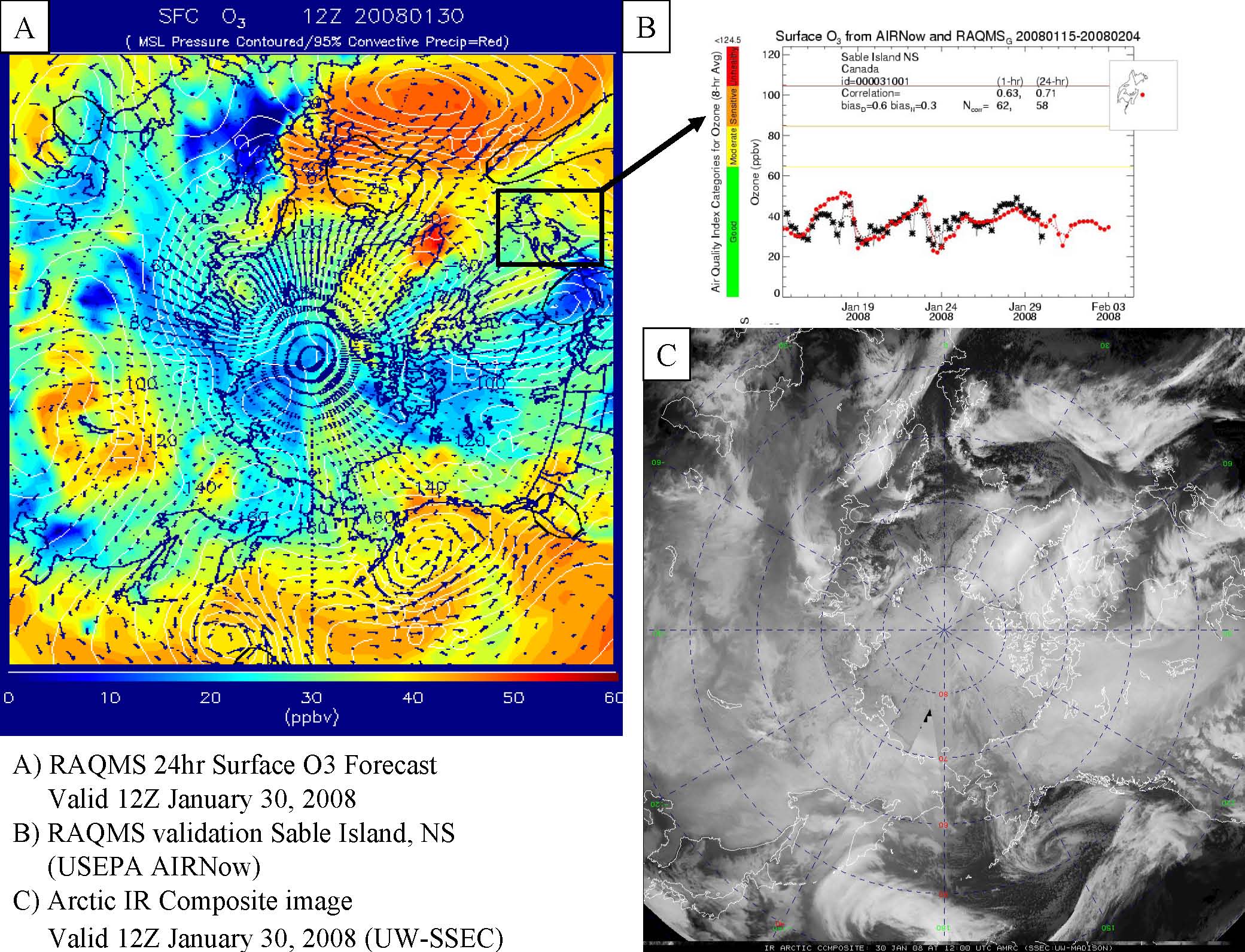
RAQMS Forecast for 2008 ARCPAC IPY Mission Initiated: Real-time
Air Quality Modeling System (RAQMS) global chemical and aerosol
forecasts have been initiated in preparation for the upcoming NOAA
Aerosol, Radiation and Cloud Processes Affecting Arctic Climate
(ARCPAC) field mission. The ARCPAC mission is one of the NOAA
International Polar Year activities and will focus on the evolution and
transport of Arctic haze. RAQMS chemical initialization includes
assimilation of near-real-time total column ozone measurements from the
NASA Ozone Monitoring Instrument (OMI) and biomass burning emissions
based on Moderate Resolution Imaging Spectroradiometer (MODIS) fire
detections. RAQMS chemical and aerosol forecasts will be used for
flight planning activities during the April 2008 Fairbanks, AK
deployment of the NOAA P3 aircraft. (R.B. Pierce, E/RA2, 608-890-1892,
brad.pierce@ssec.wisc.edu).
 (Click image to enlarge)
Figure caption: RAQMS 24hr surface ozone forecast valid at 12Z January
30, 2008. A) Ozone mixing ratios (colored, ppbv) and MSLP (contoured,
mb). B) Verification of RAQMS surface ozone analysis/forecast (red)
using near-real-time USEPA AIRNow measurements (black) at Sable Island,
NS. C) Arctic IR Composite image valid 12Z January 30, 2008 (provided by
Matthew Lazzara, UW-SSEC)
Public Outreach at the Madison Winter Festival: S.
Bachmeier, J. O'Leary, and M. Mooney set up a display booth at the
Wisconsin Historical Society as part of the Madison Winter Festival
activities on February 2, 2008. Interactive touch screen computers were
used to showcase meteorological education Java applets developed at the
Space Science and Engineering Center (SSEC) and the Cooperative
Institute for Meteorological Satellite Studies (CIMSS), including "How
a snowflake grows". Satellite imagery of winter weather in Wisconsin
was also displayed, and printed information about "Historical Weather
Extremes of Madison and Wisconsin" was made available to the public.
(S. Bachmeier, CIMSS, 608-263-3958, J. O'Leary, SSEC, 608-263-3373, M.
Mooney, SSEC, 608-265-2123)
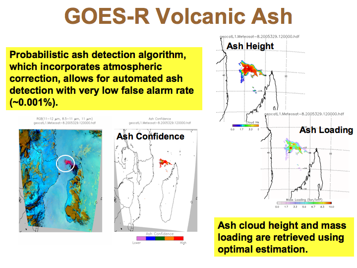
New Quantitative Volcanic Ash Products Developed for GOES-R: A
new suite of volcanic ash products, including a probabilistic ash mask,
ash cloud height, and ash cloud mass loading, were developed for GOES-R
using the Spinning Enhanced Visible and Infrared Imager (SEVIRI) as a
proxy for the Advanced Baseline Imager (ABI). The algorithms utilize
infrared measurements, which are converted into cloud emissivities,
along with spatial information. Working in cloud emissivity space
maximizes the sensitivity of the infrared measurements to volcanic ash
compared to traditionally used brightness temperature differences. As a
next step, the volcanic ash algorithms will be evaluated in near
real-time using SEVIRI. (M. Pavolonis, E/RA2, 608-263-9597,
Mike.Pavolonis@noaa.gov, J. Sieglaff, 608-265-5357)
 (Click image to enlarge)
Figure
caption: The figure shows an example of new volcanic ash products
developed for GOES-R for an eruption of Karthala on the island of
Comoros.
ITEMS FOR THE DIVISION CHIEF, CoRP:
Panel Participation at Annual AMS Meeting: Tom Whittaker of the Cooperative Institute for Meteorological Satellite Studies (CIMSS) was invited to partipate in a special joint session at the annual American Meteorological Society's (AMS) annual meeting, on January 22, 2008. The subject for this special panel discussion was "Enhancing the Connectivity of Research and Application for the Benefit of Society". Whittaker's presentation was at the request of the Conference on Interactive Information and Processing Systems (IIPS) and highlighted 24 years of history in IIPS, as well as the present and near future. The IIPS Conference is held each year in conjuction with the AMS annual meeting. The panel discussion was also highlighted on the front page of the "Daily BAMS" publication at the Meeting (http://www.ametsoc.org/MEET/annual/dailybamswednesday.pdf) (T. Whittaker, CIMSS, 608-262-2759)Other Meetings and Telecons:
None.
VISITORS:
NEXT WEEK:
LOOKING AHEAD:
| Archived Weeklies Page | Submit a report item |