
[ Archive ]

|
ASPB and CIMSS Weekly Report
[ Archive ] |
|
IN THE PRESS:
ITEMS FOR THE ADMINISTRATOR:
ITEMS FOR THE ASSISTANT ADMINISTRATOR:
ITEMS FOR THE OFFICE DIRECTOR, STAR:
First Polar Winds from AVHRR HRPT Data: As
part of the continuing effort to make polar wind information available
to numerical weather prediction (NWP) centers as quickly as possible,
winds are now being generated from Advanced Very High Resolution
Radiometer (AVHRR) data collected at the NESDIS High Resolution Picture
Transmission (HRPT) receiving station in Barrow, Alaska. The first
winds were generated on February 16, 2008. All processing is done at
the NESDIS Fairbanks Command and Data Acquisition Station. The HRPT wind
information is improved over that generated from AVHRR Global
Area Coverage (GAC) data at the Cooperative Institute for
Meteorological Satellite Studies (CIMSS) in that it is available much sooner
(e.g., 30 minutes after acquisition rather than 2-3 hours) and at a higher spatial resolution. The Barrow
HRPT winds will be made available to NWP centers after testing and
validation. (J. Key, E/RA2, 608-263-2605, jkey@ssec.wisc.edu; D.
Santek, CIMSS, 608-263-7410)
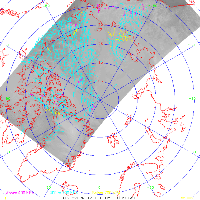 (Click image to enlarge)
Figure
caption: NOAA-16 AVHRR winds from HRPT data collected at Barrow, Alaska, on
February 17, 2008. Vectors are categorized as low (surface to 700 hPa,
yellow), middle (700-400 hPa, cyan), and high (above 400 hPa, magenta).
Numerical Forecasts Assimilating MODIS for Kazakhstan: The numerical prediction model used at the Cooperative Institute for Meteorological Satellite Studies (CIMSS), the CIMSS Regional Assimilation System (CRAS), is now generating 72-hour forecasts for Kazakhstan and the surrounding region in real time. Total precipitable water and cloud information, generated from the Moderate Resolution Imaging Spectroradiometer (MODIS), are used to initialize water vapor and clouds in the CRAS. This experimental CRAS forecast was created to demonstrate how MODIS retrievals can be used to improve the prediction of precipitation and clouds to a visiting scientist from the Hydrometeorological Monitoring Centre of Astana who hopes to acquire a MODIS direct broadcast system. Forecasts can be viewed on the web at http://cimss.ssec.wisc.edu/model/realtime/cras48_KZ/daily.html. (R. Aune, E/RA2, 608-262-1071)
ITEMS FOR THE DIVISION CHIEF, CoRP:
RAQMS AIRS Synthetic Radiance Studies: Researchers at the Cooperative Institute for Meteorological Satellite Studies (CIMSS) have been developing capabilities to simulate Atmospheric Infrared Sounder (AIRS) radiance spectra band using chemical and meteorological output from the Real-time Air Quality Modeling System (RAQMS). Comparisons between the simulated and observed spectra in the 1040 cm-1 O3 for August 16th, 2006 show promising results. Inclusion of trace gases in forward modeling capabilities supports Air Quality efforts within GOES-R Risk Reduction and GOES-R Algorithm Working Group (AWG) program. (R. B. Pierce, E/RA2, 608-890-1892, brad.pierce@noaa.gov, T. Greenwald, CIMSS, 608-262-3629, tom.greenwald@ssec.wisc.edu)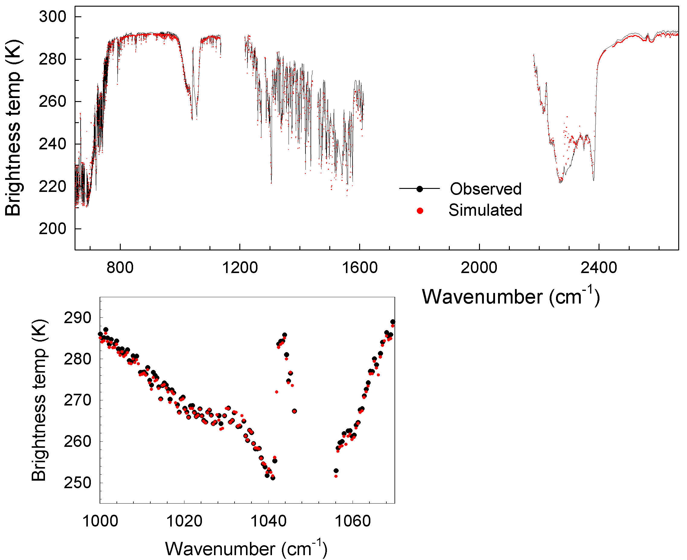 (Click image to enlarge)
 (Click image to enlarge)
Other Meetings and Telecons:
None.
VISITORS:
Visitors from Curtin University of Technology: Drs.
Peter Fearns and Mervyn Lynch from the Remote Sensing and Satellite
Research Group at Curtin University of Technology visited the
Cooperative Institute for Meteorological Satellite Studies (CIMSS) 6–8
February 2008 to discuss continued collaborations. Dr. Fearns gave a
seminar on sediment mapping along the west coast of Australia with
Landsat and the Moderate Resolution Imaging Spectroradiometer (MODIS).
It was agreed that the Curtin group would provide an suspended sediment concentration algorithm for
use in the International MODIS and AIRS Processing Package (IMAPP)
direct broadcast software. (W.P. Menzel, CIMSS, 608-263-4930)
NEXT WEEK:
LOOKING AHEAD:
| Archived Weeklies Page | Submit a report item |