
[ Archive ]

|
ASPB and CIMSS Weekly Report
[ Archive ] |
|
IN THE PRESS:
ITEMS FOR THE ADMINISTRATOR:
ITEMS FOR THE ASSISTANT ADMINISTRATOR:
Third Meeting of WMO Space Task Group for IPY: The
World Meteorological Organization's (WMO) Space Task Group (STG) for
the International Polar Year (IPY) held its third meeting May 5-6,
2008, in Frascati, Italy. The meeting was hosted by the European Space
Agency's (ESA) Centre for Earth Observation (ESRIN). The STG was
established for the purpose of space agency planning, processing, and
archiving of IPY Earth Observation legacy datasets. The primary task of
the STG is to determine the "portfolio" of IPY satellite data products
that each space agency is developing. The portfolios may be
comprised of special acquisitions, new products, new ways of accessing
existing products, operational support for IPY field programs,
agreements to release data that was not otherwise freely available, and
plans for archiving IPY legacy datasets. Jeff Key and Pablo
Clemente-Colon are NOAA representatives on the STG; Key attended the
meeting and reported on NESDIS' IPY portfolio. (J. Key, E/RA2,
608-263-2605, jkey@ssec.wisc.edu; P. Clemete-Colon, E/RA3,
pablo.clemente-colon@noaa.gov)
Significance: Space agency contributions to IPY are providing
much-needed observations of the polar regions not only during IPY, but
as part of an IPY legacy. Observations from space are an essential
component of the WMO Integrated Global Observing System (WIGOS) and,
therefore, part of the Global Earth Observation System of Systems
(GEOSS).
NOAA Mission Goals: Serve Society's Needs for Weather and Water
Information; Understand Climate Variability and Change; Support the
Nation's Commerce
NOAA Cross-Cutting Priorities: Sound, Reliable State-of-the-Art
Research; Integrating Global Environmental Observations and Data
Management
ITEMS FOR THE OFFICE DIRECTOR, STAR:
IDEA Team Recieves EPA Scientific and Technological Achievement Award: R. Bradley Pierce (NOAA/NESDIS), Elaine Prins, and Liam Gumley (Cooperative Institute for Meteorological Satellite Studies, CIMSS) received the U.S. Environmental Protection Agency 2007 Level I Scientific and Technological Achievement Award (STAA) for “Developing an Operational Fine Particulate Matter (PM2.5) Air Quality Index Forecast Tool to Improve Public Awareness” as part of a team of EPA, NASA, CIMSS, and Sonoma Technology scientists involved in Infusing Satellite Data into Environmental Applications (IDEA). STAA is among the most prestigious of EPA scientific award programs and Level I awards are for accomplishment an exceptionally high-quality research or technological effort of national significance high impact on a broad area of science/technology. (R.B. Pierce, E/RA2, 608-890-1892, brad.pierce@ssec.wisc.edu)
RAQMS/CMAQ Manuscript Published: A manuscript
assessing the impact of the downscale linkage of the Real-time Air
Quality Modeling System (RAQMS) on the simulated O3 concentration
within the EPA Models-3
Community Multiscale Air Quality (CMAQ) model (Song, et al., J.
Geophys. Res., 113, D08308, doi:10.1029/2007JD008951) was published on
April 30, 2008 in Journal of Geophysical Research. (R.B. Pierce, E/RA2, 608-890-1892, brad.pierce@noaa.gov)
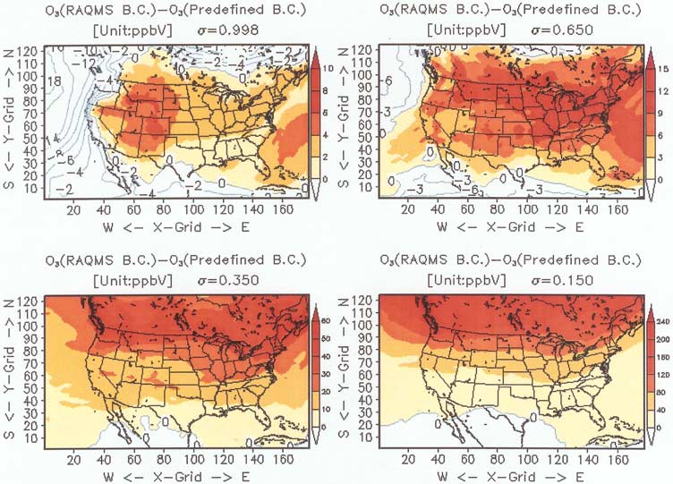 (Click image to enlarge)
Figure caption: Horizontal distribution of O3 concentration differences of the CMAQ simulations with the
lateral boundary condition estimated between from RAQMS output and from predefined default vertical
profiles at different s-levels (0.998, 0.650, 0.350, and 0.150).
Paper on the UW/CIMSS Global IR Land Surface Emissivty Database Published: A
paper titled "A global infrared surface emissivity database for clear
sky atmospheric sounding retrievals from satellite-based radiance
measurements" was published in the
Journal of Applied Meteorology and Climatology
(Vol. 47, No. 1, January 2008, pp. 108-123).
The authors are S.W. Seemann, E.E. Borbas, R.O. Knuteson, G. R.
Stephenson, and H.- L. Huang (Cooperative Institute for Meteorological
Satellite Studies, CIMSS). A global database of infrared (IR) land
surface emissivity is introduced to support more accurate retrievals of
atmospheric properties such as temperature and moisture profiles from
multispectral satellite radiance measurements (like MODIS). Emissivity
in the database is available globally at 10 wavelengths chosen as hinge
points with 0.05 degree spatial resolution.
ITEMS FOR THE DIVISION CHIEF, CoRP:
AMS Hurricane Conference: Several Cooperative Institute for Meteorological Satellite Studies (CIMSS) scientists participated in the 28th Americal Meteorological Society (AMS) Conference on Hurricanes and Tropical Meteorology, held in Orlando April 28-May 2. In addition to presentations given by these scientists, the work being done on hurricane research at CIMSS was frequently referenced and displayed in many other attendee presentations. Chris Velden and James Kossin chaired important topical sessions during the meeting, which was attended by well over 400 scientists from around the world. (C. Velden, CIMSS, 608 262-9168, James Kossin CIMSS, 608 265-5356) (Click image to enlarge)
 (Click image to enlarge)
Other Meetings and Telecons:
None.
VISITORS:
Visitor from National Severe Storms Lab
: Dr. Qin Xu from the National Severe Storms Lab (NSSL), Norman
Oklahoma, visited the Cooperative Institute for Meteorological Studies
(CIMSS) on Thursday and Friday. He has published work on extracting
wind information from consecutive radar images and is interested in
applying his technique to geostationary imagery. He presented a CIMSS
Seminar: "A Simple adjoint method for retrieving vector wind field from
radar imagery movement". Using images from the GOES imager and sounder,
he expects to produce winds that will be useful for initializing
numerical weather prediction models.
(R. Aune, E/RA2, 608-262-1071, robert.aune@noaa.gov)
NEXT WEEK:
LOOKING AHEAD:
| Archived Weeklies Page | Submit a report item |