
[ Archive ]

|
ASPB and CIMSS Weekly Report
[ Archive ] |
|
IN THE PRESS:
ITEMS FOR THE ADMINISTRATOR:
ITEMS FOR THE ASSISTANT ADMINISTRATOR:
ITEMS FOR THE OFFICE DIRECTOR, STAR:
Paper Published on Coordinated Satellite Observations During IPY: A paper titled "Coordinated Satellite Observations during the International Polar Year: Towards achieving a polar constellation" was published in Space Research Today (no. 171, pp. 6-17). The authors are Mark Drinkwater (European Space Agency), Ken Jezek (Ohio State University), and Jeff Key (NESDIS/STAR). (J. Key, E/RA2, 608-263-2605, jkey@ssec.wisc.edu)
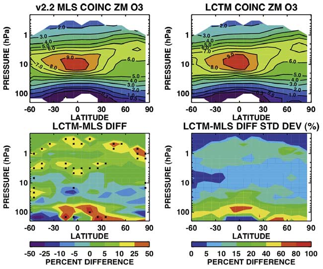
Aura MLS Non-coincident Validation Study Published: A
manuscript titled "Noncoincident validation of Aura MLS observations
using the Langley Research Center Lagrangian chemistry and transport
model" by D.B. Considine, M. Natarajan, T. D. Fairlie, G. S.
Lingenfelser, R. B. Pierce, L. Froidevaux, and A. Lambert was recently
published in the Aura Validation Special Section of the Journal of Geophysical Research-Atmospheres.
The paper presents results of an evaluation of Aura Microwave
Limb Sounder (MLS) version 2.2 measurements of O3, HCl, and H2O with version
19 Halogen Occultation Experiment (HALOE) observations using a
trajectory based, noncoincident intercomparison technique. (R.B.
Pierce, E/RA2, 608-890-1892, brad.pierce@noaa.gov)
 (Click image to enlarge)
Figure caption: Coincident zonal mean comparisons of MLS and Lagrangian Chemical Transport Model O3 for 29 November 2004.
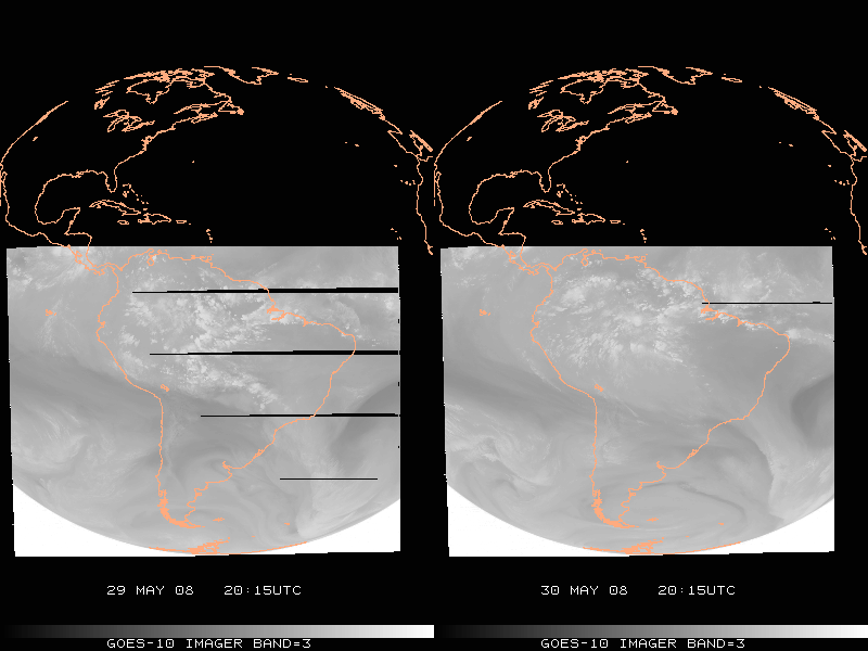
GOES-10 Imager water vapor anomaly: The Space
Science and Engineering Center (SSEC) Data Center noted an anomaly in
the Geostationary Operational Environmental Satellite (GOES)-10 band 3
(6.7 um) imagery. Given that the same areas of data outages were seen
in images from Brazil’s Instituto de Pesquisas Espaciais (INPE), it was
thought that this anomaly was not due to a local ingest. The anomaly
changes location and extent over the course of time, pointing to a
possibility that it’s related to the remapping procedure and the
growing satellite inclination. The Office of Satellite Operations was
notified and at 18:45 UTC on May 30 implemented a change that
greatly reduced the outages. (T. Schmit, E/RA2, 608-263-0291)
 (Click image to enlarge)
Figure
caption: “Before” and “After” sample GOES-10 Imager ‘water vapor’ image
that shows the anomaly (black lines of missing data). The image times
are from 21:15 UTC on May 29 and 30, 2008.
UK Met Office Begins Using AVHRR Polar Winds in Operational Forecast Model: The
Met Office (UK) began assimilating the experimental Advanced Very High
Resolution Radiometer (AVHRR) polar winds product in their operational
weather forecast system on May 20. The product is generated at the
Cooperative Institute for Meteorological Satellite Studies (CIMSS) with
AVHRR data from four NOAA satellites (NOAA-15, -16, -17, and -18). It
will become a NESDIS operational product in the very near future. The
Joint Center for Satellite Data Assimilation (JCSDA) will begin testing
the AVHRR winds soon. (J. Key, E/RA2, 608-263-2605,
jkey@ssec.wisc.edu; D. Santek, CIMSS, 608-263-7410; C. Velden, CIMSS,
608-262-9168)
ITEMS FOR THE DIVISION CHIEF, CoRP:
Air Quality Forecasts Utilizing OMI NO2 and GOES-GASP AOD Observations: Results from a collaborative Air Quality forecasting study utilizing OMI NO2 and GOES-GASP Aerosol Optical Depth (AOD) observations conducted by researchers at the Cooperative Institute for Meteorological Satellite Studies (CIMSS), US Environmental Protection Agency (EPA), Wisconsin Department of Natural Resources, and NASA Langley Research Center was presented in the "A-Train: Measuring and Assessing Air Quality" session at the Joint Assembly Meeting of the American Geophysical Union in Fort Lauderdale, FL. (R.B. Pierce, E/RA2, 608-890-1892, brad.pierce@noaa.gov)Other Meetings and Telecons:
None.
VISITORS:
NEXT WEEK:
LOOKING AHEAD:
| Archived Weeklies Page | Submit a report item |