 |
ASPB and CIMSS Weekly Report
[ Archive ] |
 |
ASPB AND CIMSS WEEKLY HIGHLIGHTS FOR THE WEEK ENDING OCTOBER 26, 2008
IN THE PRESS:
ITEMS FOR THE ADMINISTRATOR:
ITEMS FOR THE ASSISTANT ADMINISTRATOR:
ITEMS FOR THE OFFICE DIRECTOR, STAR:
ITEMS FOR THE DIVISION CHIEF, CoRP:
GRAFIIR Provides ABI SRF Analysis to AOL TAP: The Geostationary Operational Environmental Satellite (GOES)-R Analysis Facility Instrument for Impacts on Requirements (GRAFIIR) team, a GOES-R Algorithm Working Group (AWG) effort, used Infrared Atmospheric Sounding Interferometer (IASI) data and modified the Advanced Baseline Imager (ABI) Spectral Response Function (SRF) to ascertain the impacts of a different 3.9 micrometer SRF. The results were presented to the Atmosphere Ocean Land Technical Advisory Panel (AOL TAP) on 22 October 2008 via teleconference. The impact on brightness temperatures was non-trivial, demonstrating that accurate SRF knowledge is critical. (M. Gunshor, CIMSS, 608-263-1146, T. Schmit, E/RA2, 608-263-0291, tim.j.schmit@noaa.gov)
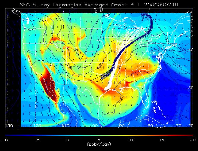
Air Quality Manuscript Submitted to JGR TexAQS Special Issue: A manuscript entitled "Impacts of background ozone production on Houston and Dallas, TX Air Quality during the TexAQS field mission" by Pierce et al. was submitted to the Journal of Geophysical Research-Atmospheres Special Journal Section for TexAQS/GoMACCS Field Study. This study demonstrates how global chemical data assimilation systems, combined with Lagrangian trajectory techniques, can be used to quantify the impacts of background ozone production on the Houston and Dallas metropolitan areas.(R.B. Pierce, E/RA2, 608-890-1892, brad.pierce@ssec.wisc.edu)
 (Click image to enlarge)
Figure caption: Synoptic distribution of 5-day Lagrangian averaged O3 P-L (ppbv/day colored) for parcels initialized at the surface at 18Z on September 2, 2006. 5-day Houston (white) and Dallas (blue) AIRNow ensemble back trajectories initialized at 18Z on September 2, 2006 and surface wind vectors and sea-level pressure (mb) are also shown.
Cloud and Moisture Imagery ADR: On October 23, T. Schmit led the Geostationary Operational Environmental Satellite (GOES)-R Advanced Baseline Imager (ABI) Cloud and Moisture Imagery Product (CMIP) Algorithm Working Group (AWG) Algorithm Design Review (ADR). M. Gunshor, K. Bah T. Rink and S. Wanzong also attended via a telecon. Cloud and moisture imagery is the tier 1a product for GOES-R. (T. Schmit, E/RA2, 608-263-0291, tim.j.schmit@noaa.gov)
CCSDS 2008 Fall Meeting: Bormin Huang attended the Consultative Committee for Space Data Systems (CCSDS) Multispectral and Hyperspectral Data Compression (MHDC) Working Group 2008 Fall Meeting, October 14-17, Berlin, Germany. He gave 2-hour presentations on (1) Fast Linear-Time Minimum-redundancy Prefix Coding & its FPGA Chip Implementation for Real-time Space Data Compression, (2) Lossless Compression of the Geostationary Imaging Fourier Transform Spectrometer (GIFTS) Data via Predictive Partitioned Vector Quantization (PPVQ): Preliminary Studies Beneficial to the EUMETSAT Meteosat Third Generation (MTG) Infrared Sounder (IRS), (3) Optimal Code Rate Allocation with Turbo Product Codes for JPEG2000 Compression of Ultraspectral Sounder Data, and (4) Burst Error Studies with DVB-S2 and 3DWT Reversible Variable-Length Coding for Ultraspectral Sounder Data Compression. (B. Huang, CIMSS, 608-265-2231, bormin@ssec.wisc.edu)
CIMSS VISIT Activities: The Virtual Institute for Satellite Integration Training (VISIT) distance learning lesson "Interpreting Satellite Signatures" (http://rammb.cira.colostate.edu/visit/sat_signatures.html) was led by S. Lindstrom from the Cooperative Institute for Meteorological Satellite Studies (CIMSS) on October 22, 2008. Staff from the National Weather Service (NWS) forecast office at Caribou (Maine), Gaylord (Michigan), Pendleton (Oregon), and the NWS Office of Science and Technology (OST) participated in the VISIT lesson. (S. Lindstrom, CIMSS, 608-263-4425)
VISITORS:
NEXT WEEK:
LOOKING AHEAD: