
[ Archive ]

|
ASPB and CIMSS Weekly Report
[ Archive ] |
|
IN THE PRESS:
ITEMS FOR THE ADMINISTRATOR:
ITEMS FOR THE ASSISTANT ADMINISTRATOR:
ITEMS FOR THE OFFICE DIRECTOR, STAR:
EUMETSAT Cloud Workshop: Andrew Heidinger
chaired a session at the Second Cloud Workshop sponsored by the
European Organisation for the Exploitation of Meteorological Satellites
(EUMETSAT). The meeting was held in Locarno, Switzerland and brought
together most of the European and American teams conducting real-time
cloud remote sensing with EUMETSAT satellites. Andrew Heidinger
represented the NESDIS real-time imager-based cloud products. A
workshop report, written by Andi Walther, is available that provides a
common comparison of all submitted data-sets. (A. Heidinger, E/RA2,
608-263-6757, A. Walther, CIMSS, 608-890-0710)
ITEMS FOR THE DIVISION CHIEF, CoRP:
CIMSS VISIT Activities: The Virtual Institute for Satellite Integration Training (VISIT) distance learning lessons "Cooperative Institute for Meteorological Satellite Studies (CIMSS) Regional Assimilation System (CRAS) Forecast Imagery in Advanced Weather Interactive Processing System (AWIPS)" (http://rammb.cira.colostate.edu/visit/CRAS_AWIPS.html) and "Moderate Resolution Imaging Spectroradiometer (MODIS) Products in AWIPS" (http://cimss.ssec.wisc.edu/goes/visit/modis.html) were led by staff from CIMSS on February 10 and 11, 2009. Forecasters from three National Weather Service (NWS) offices (Bismarck, North Dakota; Omaha, Nebraska; Glasgow, Montana) participated in the VISIT lessons. In addition, the CIMSS Satellite Blog (http://cimss.ssec.wisc.edu/goes/blog/) was updated with examples of Geostationary Operational Environmental Satellite (GOES) and MODIS imagery showing melting snow and thinning lake ice in Wisconsin, a tornado outbreak in Texas and Oklahoma, and aircraft "hole punch" and "distrail" clouds in Texas. (S. Bachmeier, CIMSS, 608-263-3958, S. Lindstrom, CIMSS, 608-263-4425)
Retroactive Intercalibration of GOES and AIRS: Researchers at the Cooperative Institute for Meteorological Satellite Studies (CIMSS) have done a retroactive intercalibration study comparing infrared channels on Geostationary Operational Environmental Satellite (GOES) Imagers on GOES-10, -11, -12, and -13 to high spectral resolution Atmospheric InfraRed Sounder (AIRS). AIRS data covering nearly six years (January 2003 through the end of 2008) provide a continuous record of well-calibrated data for these comparisons which were done with a consistent algorithm. GOES Imagers appear to be well calibrated in all bands and compare well to AIRS and within 0.5 K of each other with the one exception of the 13.3 micrometer band on GOES-12 and -13 (which has become a known issue). A poster with the results was presented at the American Meteorological Society (AMS) Satellite Meteorology and Oceanography Conference in January 2009. (M. Gunshor, CIMSS, 608-263-1146, T. Schmit, E/RA2, 608-263-0291, tim.j.schmit@noaa.gov)
Manuscript on Regional Contributions to Baltimore MD Aerosols Accepted to Atmospheric Environment: A manuscript entitled "Lagrangian Sampling of 3-d Air Quality Model Results for Regional Transport Contributions to Sulfate Aerosol Concentrations at Baltimore, MD, in Summer 2004." by Thomas D Fairlie, James Szykman, Alice Gilliland, Robert B Pierce; Chieko Kittaka, Stephanie Weber, Jill Engel-Cox, Raymond R Rogers, Joe Tikvart, Richard Scheffe, and Fred Dimmick has been accepted to Atmospheric Environment. The research presented in the paper uses Community Multiscale Air Quality (CMAQ) modeling results, air monitoring networks, and satellite (Moderate Resolution Imaging Spectroradiometer, MODIS) observations to provide source apportionment for sulfate aerosol and PM2.5 concentrations at Baltimore, MD. (R.B. Pierce, E/RA2, 608-890-1892, brad.pierce@noaa.gov)
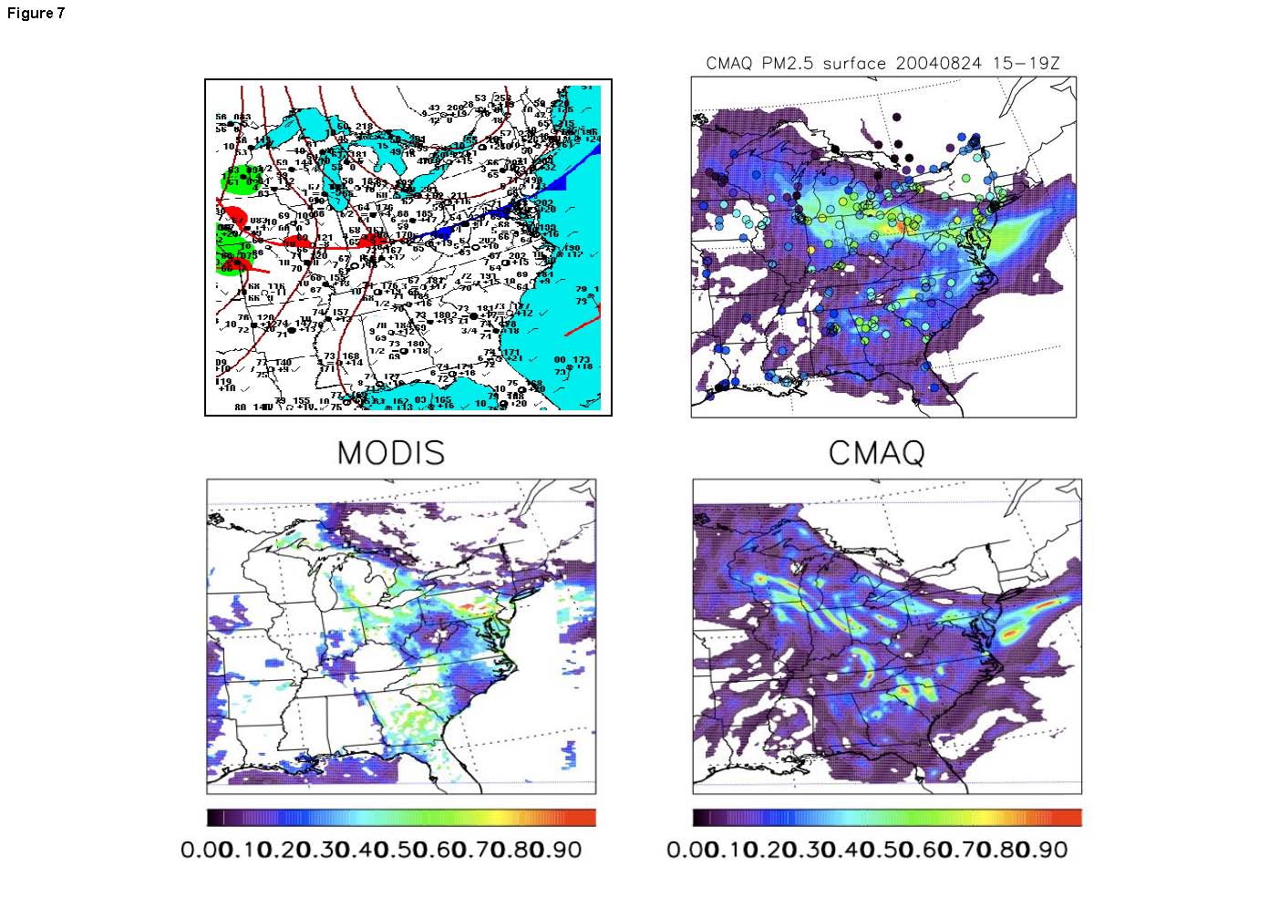 (Click image to enlarge)
VISITORS:
NEXT WEEK:
LOOKING AHEAD:
| Archived Weeklies Page | Submit a report item |