
[ Archive ]

|
ASPB and CIMSS Weekly Report
[ Archive ] |
|
IN THE PRESS:
ITEMS FOR THE ADMINISTRATOR:
ITEMS FOR THE ASSISTANT ADMINISTRATOR:
ITEMS FOR THE OFFICE DIRECTOR, STAR:
Science Open House at University of Wisconsin, Madison:
On Saturday, April 4, the University of Wisconsin held it's Science
Expeditions Program, a campus-wide open house promoting science and
technology. R. Aune (NESDIS/STAR) and J. Gerth (Cooperative Institute
for Meteorological Satellite Studies, CIMSS) gave presentations on
applications of satellite data in forecasting and numerical weather
prediction as part of a team from the Space Science and Engineering
Center (SSEC). J. Gerth demonstrated how satellite observations are
used in the National Weather Service's Advanced Weather Information
Processing System (AWIPS). (R. Aune, E/RA2, 608-262-1071 and J.Gerth,
CIMSS, 608-263-4942)
NWS Seminar on the GOES-R ABI: Tim Schmit
gave presentation on April 8 in Silver Spring, MD, as part of the
National Weather Service (NWS) Science and Technology seminar series.
The title of the presentation was “The ABI (Advanced Baseline Imager)
on the GOES (Geostationary Operational Environmental Satellite)-R
series." The presentation is available at http://www.weather.gov/mdl/seminar/index.php. Approximately 50 people attended. (T. Schmit, E/RA2, 608-263-0291, tim.j.schmit@noaa.gov)
ITEMS FOR THE DIVISION CHIEF, CoRP:
Near Real Time South Pole Composite Winds: For the first time, near real-time composite winds over the South Pole are being generated. This is a joint project that included the development of hourly composites of geostationary and polar-orbiting satellite data by Matthew Lazzara and Jerry Robaidek (Space Science and Engineering Center, SSEC), and the development of cloud motion vectors by Richard Dworak and Dave Santek (Cooperative Institute for Meteorological Satellite Studies, CIMSS). This has the potential to fill a vital gap in the observing network over the Southern Oceans from 50 to 65 degrees latitude, where very little wind observations are available for forecast model assimilation. The next step in this project is to validate the winds by comparing them to radiosonde and other wind observations. (R. Dworak, CIMSS, 608-265-8620)
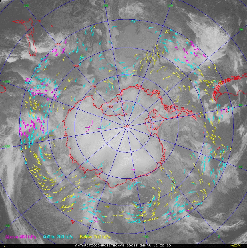 (Click image to enlarge)
Figure caption: Composite winds over the South Pole on 26 March, 12 UTC.
Satellite Imagery of Wildfires in Texas and Oklahoma: Geostationary Operational Environmental Satellite (GOES) and Moderate Resolution Imaging Spectroradiometer (MODIS) images showing the large outbreak of fires across parts of Texas and Oklahoma on April 9, 2009 were added to the Cooperative Institute for Meteorological Satellite Studies (CIMSS) Satellite Blog (http://cimss.ssec.wisc.edu/goes/blog/archives/2370). Large smoke plumes were seen on GOES visible imagery, and GOES and MODIS shortwave InfraRed (IR) imagery depicted a number of very hot pixels associated with these fires. (S. Bachmeier, CIMSS, 608-263-3958).
Seminar on Convective Clouds: M. Pavolonis
(NOAA/NESDIS) gave a seminar in the Department of Atmospheric and
Oceanic Sciences (AOS) at the University of Wisconsin. The seminar,
entitled, “The Temporal and Radiometric Evolution of Mid-Latitude Deep
Convection Observed by Satellites,” described recent research on using
observations of convective clouds from the Geostationary Operational
Environmental Satellite (GOES) to improve our understanding and
prediction of severe weather events. One of the main points of the talk
was that convective cloud systems are enormously complex and a rigorous
treatment of the radiative transfer across the infrared spectrum is
needed in order to better understand the dynamic and thermodynamic
processes driving the storm. (M. Pavolonis, E/RA2, 608-263-9597,
Mike.Pavolonis@noaa.gov)
VISITORS:
NEXT WEEK:
LOOKING AHEAD:
| Archived Weeklies Page | Submit a report item |