
[ Archive ]

|
ASPB and CIMSS Weekly Report
[ Archive ] |
|
IN THE PRESS:
ITEMS FOR THE ADMINISTRATOR:
ITEMS FOR THE ASSISTANT ADMINISTRATOR:
ITEMS FOR THE OFFICE DIRECTOR, STAR:
OAR-NESDIS Workshop on Joint Field Campaigns: Brad Pierce attended a joint NESDIS OAR-NESDIS workshop in Silver Spring, MD focusing on improving coordination related to joint field campaigns. The objective of the meeting was to share and collect perspectives from OAR and NESDIS line offices regarding impediments and opportunities for improving collaboration. He led a breakout group that focused on means of establishing greater involvement of NESDIS in planning and execution of field campaigns and enabling collaborative research. (R.B. Pierce, E/RA2, 608-890-1892, brad.pierce@noaa.gov)
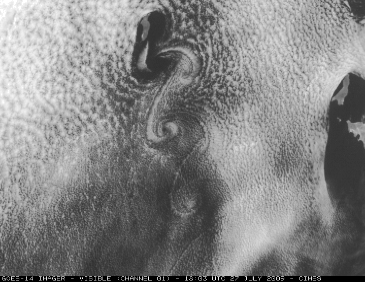
First GOES-14 full-disk visible image: The
first Geostationary Operational Environmental Satellite (GOES)-14
full-disk visible image was received on 27
July 2009 starting at 1730 UTC. This image was ingested by the Space
Science and Engineering Center (SSEC) Data Center and displayed in realtime
at http://www.ssec.wisc.edu/media/spotlight/goes14/. The Cooperative Institute for Meteorological Satellite Studies (CIMSS) Satellite blog posted high spatial resolution images: http://cimss.ssec.wisc.edu/goes/blog/archives/3054. For more information, see http://www.star.nesdis.noaa.gov/star/GOES-14FirstImage.php or the NOAA Science Test page at http://rammb.cira.colostate.edu/projects/goes-o/. (T. Schmit, E/RA2, 608-263-0291, tim.j.schmit@noaa.gov; S. Bachmeier, CIMSS, 608-263-3958)
 (Click image to enlarge)
Figure caption: GOES-14 visible image which showed von Karman vorticies
streaming southward from Guadalupe Island off the west coast of Baja
California.
CIMSS Summer Workshop for High School Students: From
26 through 30 July 2009, the Cooperative Institute for Meteorological
Satellite Studies (CIMSS) held the 17th offering of its high school
Workshop for Atmospheric, Earth, and Space Sciences on the University
of Wisconsin-Madison campus. The workshop included field trips to a
local television station and private weather company, the nearby NOAA
National Weather Service (NWS) forecast office in Sullivan, WI, the
nearby Baraboo Range (for a geological tour), and Lake Mendota (for -
newly successful this year - a limnology dredging expedition). Fourteen
students participated, with an even mix of girls and boys, and seven
traveling from out of state. Numerous presentations were given on a
variety of science topics, with emphasis on weather and satellite
remote sensing. NOAA Advanced Satellite Products Branch (ASPB) members
provided significant contributions (R. Aune, on numerical weather
prediction; T. Schmit, on the Geostationary Operational Environmental
Satellite (GOES) program; and G. S. Wade, on the Man computer
Interactive Data Access System (McIDAS), with transition to the latest
version: McIDAS-V). More information is available at http://cimss.ssec.wisc.edu/studentworkshop/index.html.
(J. Gerth, CIMSS, 608-263-4942, jordang@ssec.wisc.edu; G.S. Wade,
E/RA2, 608-263-4743, gary.s.wade@noaa.gov; M. Mooney, CIMSS,
608-265-2123, margaret.mooney@ssec.wisc.edu)
ITEMS FOR THE DIVISION CHIEF, CoRP:
GOES-R Aviation Requirement Overview Presented to NextGen Environmental Information Team: Wayne Feltz (Cooperative Institute for Meteorological Satellite Studies, CIMSS) presented a GOES-R aviation requirement overview to Joint Program Development Office (JPDO) NextGen Environmental Information team on July 24, 2009. An overview regarding satellite-based turbulence, convective initiation, overshooting-top, volcanic ash, icing, and visibility was provided to multi-agency team (NASA, NOAA, FAA, DOD, DOC). Feedback back included more connectivity between JPDO NextGen implementation (2012-2025) and availability of GOES-R aviation decision support products by 2016. (W. Feltz, CIMSS, 608-265-6283) (Click image to enlarge)
VISITORS:
NEXT WEEK:
LOOKING AHEAD:
| Archived Weeklies Page | Submit a report item |