
[ Archive ]

|
ASPB and CIMSS Weekly Report
[ Archive ] |
|
IN THE PRESS:
ITEMS FOR THE ADMINISTRATOR:
ITEMS FOR THE ASSISTANT ADMINISTRATOR:
ITEMS FOR THE OFFICE DIRECTOR, STAR:
NASA Group Achievement Award for ARCTAS Field Mission: Brad Pierce received a NASA Group Achievement Award for outstanding accomplishments in the successful Arctic Research of the Composition of the Troposphere with Aircraft and Satellites (ARCTAS) mission in Alaska and Canada. The ARCTAS field mission was NASA's largest commitment to research in support of the International Polar Year (IPY) and was sponsored by NASA's Tropospheric Chemistry and Radiation Sciences Program. The NASA effort contributed to a larger interagency and international effort called POLARCAT (Polar Study using Aircraft, Remote Sensing, Surface Measurements and Models, of Climate, Chemistry, Aerosols, and Transport)(R.B. Pierce, E/RA2, 608-890-1892, brad.pierce@noaa.gov)
Manuscript on Applications of High Spectral and Temporal Resolution Measurements Published: A
journal article titled "Inferring Convective Weather Characteristics
with Geostationary High Spectral Resolution IR (infrared) Window
Measurements: A Look into the Future" has been published in the August
2009 issue of the Journal of Atmospheric and Oceanic Technology
(JTECH). A PDF copy of the article is available at http://ams.allenpress.com/perlserv/?request=res-loc&uri=urn%3Aap%3Apdf%3Adoi%3A10.1175%2F2009JTECHA1210.1
Authors are Justin M. Sieglaff (Cooperative Institute for
Meteorological Satellite Studies (CIMSS)), Timothy J. Schmit
(NOAA/NESDIS), W. Paul Menzel (CIMSS), and Steven A. Ackerman (CIMSS).
(J. Sieglaff, CIMSS, 608-265-5357; T. Schmit, E/RA2, 608-263-0291,
tim.j.schmit@noaa.gov)
ITEMS FOR THE DIVISION CHIEF, CoRP:
Simulation of the Edmond Fitzgerald Storm Used in Documentary: Forecast maps of the storm that sank the SS Edmond Fitzgerald on November 10, 1975, were provided to a film company producing a documentary on the event for The National Geographic Society. Scientists at the Cooperative Institute for Meteorological Satellite Studies (CIMSS) used the CIMSS Regional Assimilation System (CRAS) to generate the forecast for a basic meteorology course given by the Atmospheric and Oceanic Sciences Department at the University of Wisconsin, Madison. The products are available for viewing on the web at http://cimss.ssec.wisc.edu/model/cras61_EF/cras61_EF.html. (R. Aune, E/RA2, 608-262-1071)
Visit to Colorado State University: Andrew Heidinger visited the Cooperative Institute for Research in the Atmosphere (CIRA) and the NOAA/NESDIS Regional and Mesoscale Meteorology Branch (RAMMB) located at Colorado State University (CSU). While there, he gave a colloquium to the Atmospheric Science Department that dealt with some of the infrared cloud remote sensing advances offered by GOES-R. He also met with several students interested in careers with NOAA. (A. Heidinger, E/RA2, 608-263-6757, Andrew.Heidinger@noaa.gov)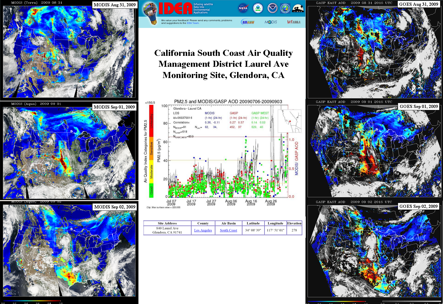 (Click image to enlarge)
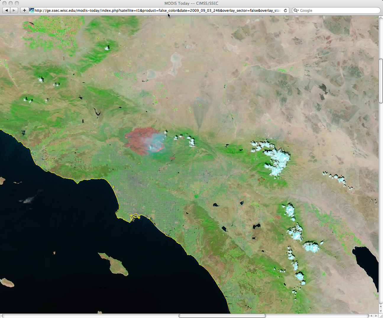 (Click image to enlarge)
VISITORS:
Graduate Students from CREST Visit CIMSS/ASPB: Two graduate students from the NOAA Cooperative Remote Sensing Science and Technology Center (CREST) group at the City College of New York (CCNY) visited the NOAA Advanced Satellite Product Branch (ASPB) and the Cooperative Institute for Meteorological Satellite Studies (CIMSS) for one week. Julia He is working on improving the performance of Geostationary Operational Environmental Satellite (GOES) aerosol retrievals in the New York City Region. Ana Picon is working on improving surface reflectance models for aerosol retrievals over land. Both gave seminars. B. Pierce and T. Schmit of ASPB aided Julia in confirming a geolocation offset in the operational GOES aerosol product. (A. Heidinger, E/RA2, 608-263-6757,Andrew.Heidinger@noaa.gov, R.B. Pierce, E/RA2, 608-890-1892, T. Schmit, E/RA2, 608-263-6013)
NEXT WEEK:
LOOKING AHEAD:
| Archived Weeklies Page | Submit a report item |