
[ Archive ]

|
ASPB and CIMSS Weekly Report
[ Archive ] |
|
IN THE PRESS:
ITEMS FOR THE ADMINISTRATOR:
ITEMS FOR THE ASSISTANT ADMINISTRATOR:
ITEMS FOR THE OFFICE DIRECTOR, STAR:
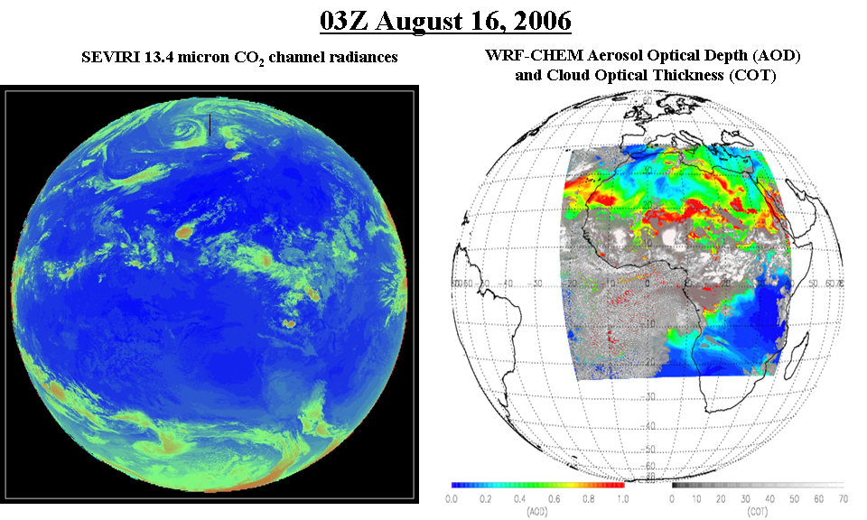
GOES-R 4km SEVIRI Aerosol Proxy Simulation Initiated: The
first three hours of a planned 30 hour, 4km Weather Research and
Forecast (WRF) coupled with Chemistry (WRF-Chem) simulation over the
Spinning Enhanced Visible and Infrared Imager (SEVIRI) domain has been
completed at the National Center for Supercomputing Applications (NCSA)
Cobalt computer in Champaign, IL. This simulation includes heavy smoke
and dust aerosols over the African continent for use in GOES-R Proxy
data studies. The simulation requires special system administration
approval due to its large use of NCSA resources. The 3-hour simulation
utilized 50% (256 processors) of the Cobalt computer for a total of 33
hours of wall clock time. (R.B. Pierce, E/RA2, 608-890-1892,
brad.pierce@noaa.gov)
 (Click
image to enlarge)
(Click
image to enlarge)
Figure caption: WRF-CHEM simulated Aerosol Optical Depth (AOD) and Cloud
Optical Thickness (COT) and SEVIRI 13.4 micron CO2 channel radiances at
03Z on August 16, 2006.
ITEMS FOR THE DIVISION CHIEF, CoRP:
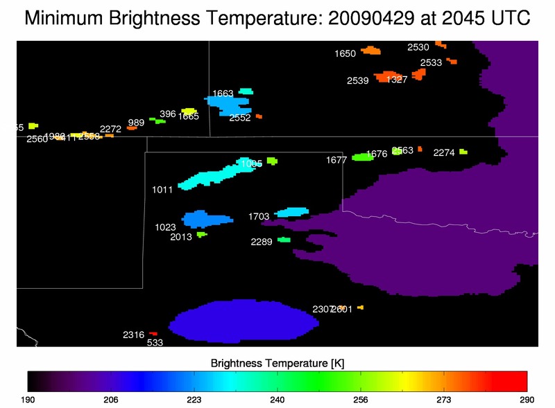
MODIS Science Team Presentations: Mike Pavolonis and Andrew Heidinger attended the meeting of the Moderate Resolution Imaging Spectroradiometer (MODIS) Atmospheres Science Team this week in Washington D.C. Pavolonis and Heidinger presented two posters that highlight their work on using the MODIS infrared observations for studying ice cloud physics. Heidinger also spoke during a breakout session on new concepts for generating climate records from MODIS. (M. Pavolonis, E/RA2, 608-263-9597, mpav@ssec.wisc.edu, A. Heidinger, E/RA2, 608-263-6757, andrew.heidinger@noaa.gov) (Click image to enlarge)
VISITORS:
Dr. Valliappa Lakshmanan of University of
Oklahoma Visits CIMMS: Dr. Valliappa Lakshmanan visited the Cooperative Institute for Meteorological Satellite Studies (CIMSS) and met with Wayne Feltz,
Justin Seiglaff, Lee Cronce, and Kristopher Bedka (SSAI NASA LaRC), to
discuss common approaches for object tracking satellite data using the
Warning Decision Support System - Integrated Information (WDSS-II). The
research goal is to apply radar centric advanced object tracking
methodology onto satellite-derived cloud properties such as top of
atmosphere emissivity. Both cooperative institutes are funded by a
common NOAA GIMPAP grant to validate and improve convective initiation
detection. Wayne Feltz will be visiting Norman, Oklahoma in February
and March to continue collaboration. (W. Feltz, CIMSS, 608-265-6283)
 (Click image to enlarge)
Figure caption: Example of WDSS-II object tracking of GOES-12 top of
atmosphere emissivity between image times 2030-2045 with unique ID
numbers. Shading corresponds to minimum brightness temperature.
NEXT WEEK:
LOOKING AHEAD:
| Archived Weeklies Page | Submit a report item |