
[ Archive ]

|
ASPB and CIMSS Weekly Report
[ Archive ] |
|
IN THE PRESS:
ITEMS FOR THE ADMINISTRATOR:
ITEMS FOR THE ASSISTANT ADMINISTRATOR:
ITEMS FOR THE OFFICE DIRECTOR, STAR:
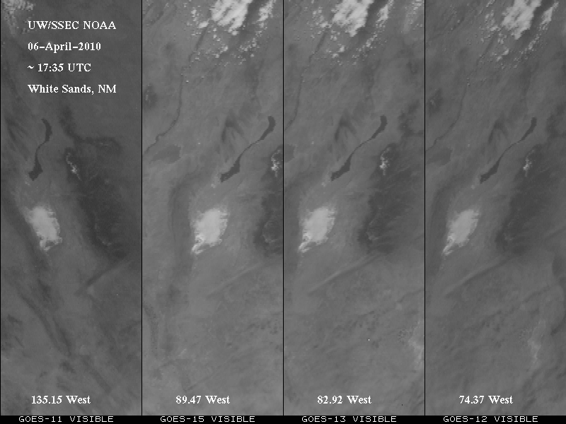
First GOES-15 Full-disk Visible Images: The
first Geostationary Operational Environmental Satellite (GOES)-15 Imager
full-disk visible image from was received on 6 April 2010 starting at
1733 UTC. This image was ingested by the Space Science and Engineering Center's
(SSEC) Data Center and displayed in realtime at
http://www.ssec.wisc.edu/media/spotlight/goes15/. The Cooperative
Institute for Meteorological Satellite Studies (CIMSS) Satellite Blog
posted several high spatial resolution images (http://cimss.ssec.wisc.edu/goes/blog/archives/5005). A large full disk
image created by ASPB (Advanced Satellite Products Branch) was used in
both the NOAA and NASA GOES-15 press releases (http://www.noaanews.noaa.gov/stories2010/20100407_goes15.html
and http://www.nasa.gov/mission_pages/GOES-P/news/first-image.html). The
first GOES-15 Sounder visible image was scanned on 8 April 2010 (http://cimss.ssec.wisc.edu/goes/blog/archives/5045). Also see the NOAA
Science Test page at http://rammb.cira.colostate.edu/projects/goes-p/.
(T. Schmit, E/RA2, 608-263-0291, tim.j.schmit@noaa.gov, S. Bachmeier,
CIMSS, 608-263-3958)
 (Click
image to enlarge)
(Click
image to enlarge)
Figure caption: The view of White Sands, NM from four GOES Imagers in
the visible spectral region on 6 April 2010. The four GOES sub-point
longitudes are noted on each panel.
ITEMS FOR THE DIVISION CHIEF, CoRP:
CIMSS Adds Another Station to the Real-time GOES Weighting Functions Website: At the request of Luis Rosa, a National Weather Service (NWS) forecaster in Puerto Rico, the San Juan station was added to the Cooperative Institute for Meteorological Satellite Studies (CIMSS) real-time weighting functions web page. The web page aims to be a tool for forecasters, researchers, and educators. The 00 and 12 UTC radiosonde data from stations, mostly in the continental United States, are used to generate weighting functions for the infrared bands on the operational Geostationary Operational Environmental Satellites (GOES) Imager and the water vapor absorption bands on the Sounder. Some Hawaiian, Alaskan, and South American stations have been added at the request of Virtual Institute for Satellite Integration Training (VISIT) trainers and users and this fulfills the most recent user request, the first from a United States territory. The web page is http://cimss.ssec.wisc.edu/goes/wf. (M. Gunshor, CIMSS, 608-263-1146)NEXT WEEK:
LOOKING AHEAD:
| Archived Weeklies Page | Submit a report item |