[ Archive ]

 |
ASPB and CIMSS Weekly Report
[ Archive ] |
 |
IN THE PRESS:
ITEMS FOR THE ADMINISTRATOR:
ITEMS FOR THE ASSISTANT ADMINISTRATOR:
ITEMS FOR THE OFFICE DIRECTOR, STAR:
First GOES-15 Imager Full-Disk Infrared Images: The
first Geostationary Operational Environmental Satellite (GOES)-15
Imager full-disk infrared image from was received on 26 April 2010
starting at 1730 UTC (Universal Time, Coordinated). This image was
ingested by the Space Science and Engineering (SSEC) Data Center (http://www.ssec.wisc.edu/media/spotlight/goes15/ir.html). The Cooperative
Institute for Meteorological Satellite Studies (CIMSS) Satellite Blog
posted several high spatial resolution images and comparisons (http://cimss.ssec.wisc.edu/goes/blog/archives/5353). Images created by
ASPB (Advanced Satellite Products Branch) were used in both the NOAA and
NASA GOES-15 press releases:
http://www.noaanews.noaa.gov/stories2010/20100427_goes.html
and http://www.nasa.gov/mission_pages/GOES-P/news/infrared-image.html.
Also see the NOAA Science Test page at
http://rammb.cira.colostate.edu/projects/goes-p/ and the STAR news page at
http://www.star.nesdis.noaa.gov/star/news2010_201004_GOES15.php#GOES15-IR.
(T. Schmit, E/RA2, 608-263-0291, tim.j.schmit@noaa.gov, S. Bachmeier,
CIMSS, 608-263-3958)
(Click image to enlarge)
Figure caption: GOES-13 and GOES-15 13.3 µm CO2 channel images at 17:30
UTC on 26 April 2010. The finer spatial resolution (4km versus 8 km
field-of-view) on GOES-15 is clearly seen. Note also the cleaner signal
from GOES-15.
International Operational Aerosol Observability
Workshop: Brad Pierce gave an invited talk summarizing aerosol,
wildfire, and biomass burning emission products from NOAA operational
satellites at the International Operational Aerosol Observability
Workshop in Monterey, CA on April 27-29, 2010. The workshop was
co-organized by the Naval Research Laboratory (NRL), European Center for
Medium range Weather Forecasting (ECMWF), the National Aeronautics and
Space Administration (NASA), and the University of Iowa to discuss the
problem of aerosol observability and predictability. This first
workshop provided an opportunity for operational centers to describe
their current state of atmospheric composition forecast development and
discuss operational observability requirements for data assimilation and
verification with potential data providers. Shobha Kondragunta, Istvan
Laszlo, and Mitch Goldberg (STAR) were co-authors on the presentation.
(R.B. Pierce, E/RA2, 608-890-1892, brad.pierce@ssec.wisc.edu)
NOAA Volcanic Ash Working Group: In response
to the Eyjafjallajokull eruptions in Iceland, NOAA has formed a Volcanic Ash
Working Group (VAWG). Davida Streett (Office of Satellite Data
Processing and Distribution, OSDPD), Grace Swanson (OSDPD), and Michael
Pavolonis (STAR) are the NESDIS members of this working group, which is
composed of representatives from the National Weather Service (NWS), the
Office of Oceanic and Atmospheric Research (OAR), and NESDIS. The
working group consists of a services team and a science team. M.
Pavolonis is a member of the science team. The first major
responsibility of the science team is to compose a paper on current
United States volcanic ash modeling and observing capabilities, gaps,
and major science and technology issues. The paper will be presented at
the Sixty-second Session of the World Meteorological Organization (WMO)
Executive Council in June 2010. (M. Pavolonis, E/RA2, 608-263-9597,
Mike.Pavolonis@noaa.gov)
Nowcasting Satellite Application Facility 2010 Users' Workshop: The EUMETSAT Nowcasting (NWC) Satellite Application Facility (SAF) 2010 Users' Workshop was held in Madrid, Spain from 26 - 18 April 2010. About 50 international users and algorithm scientists attended the workshop, Jun Li (Cooperative Institute for Meteorological Satellite Studies, CIMSS) attended the workshop and gave presentation titled "High impact weather nowcasting and short range forecasting using future geostationary advanced IR sounding data". During the workshop, he also discussed algorithm strategy for next generation of geostationary satellite products, data reduction, user readiness and product quality monitoring. (Jun Li, CIMSS, Jun.Li@ssec.wisc.edu, 608-262-3755)
ITEMS FOR THE DIVISION CHIEF, CoRP:
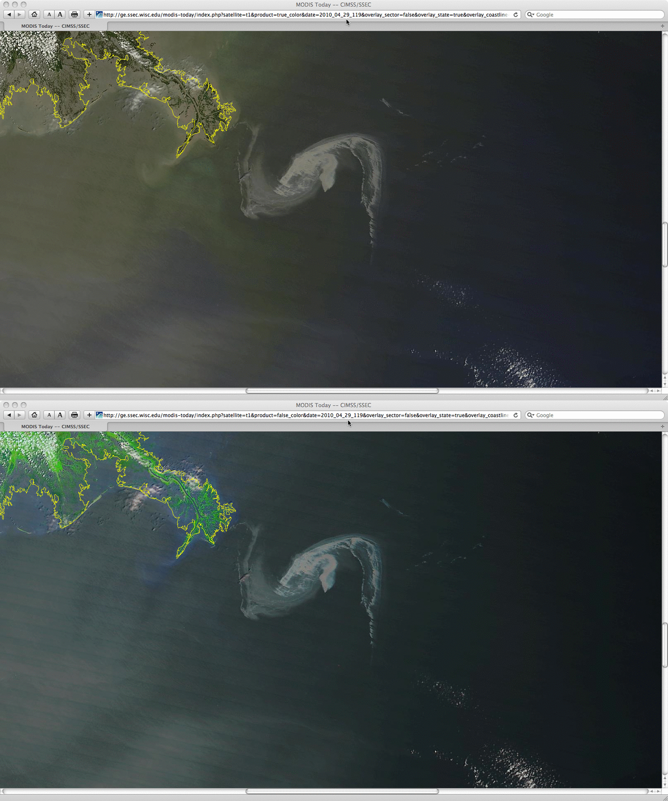
Satellite of Oil Rig Fire and Oil Slick in the Gulf of Mexico: Geostationary Operational Environmental Satellite (GOES-13) visible and shortwave IR images were posted on the Cooperative Institute for Meteorological Satellite Studies (CIMSS) Satellite Blog on April 21 (http://cimss.ssec.wisc.edu/goes/blog/archives/5240), which showed the "hot spot" and smoke plume resulting from an explosion and fire aboard the offshore oil rig “Deepwater Horizon” in the northern Gulf of Mexico late in the evening on April 20, 2010. Over the course of the following week, Moderate Resolution Imaging Spectroradiometer (MODIS) true color and false color images acquired by the Space Science and Engineering Center (SSEC) MODIS Direct Broadcast ground station (and processed for display on the SSEC MODIS Today site) were then used to identify and track the movement of the resulting oil slick following the eventual collapse of the oil rig (http://cimss.ssec.wisc.edu/goes/blog/archives/5399). In addition, Sea Surface Temperature (SST) products derived from MODIS and Advanced Very High Resolution Radiometer (AVHRR) data revealed that the oil slick exhibited SST values that were often 5-10 degrees F cooler than the surrounding waters in the northern Gulf of Mexico. Some of these satellite images were also featured on Chicago's WGN Weather Center Blog. (S. Bachmeier, CIMSS, 608-263-3958) (Click image to enlarge)
VISITORS:
NEXT WEEK:
LOOKING AHEAD:
| Archived Weeklies Page | Submit a report item |