
[ Archive ]

|
ASPB and CIMSS Weekly Report
[ Archive ] |
|
IN THE PRESS:
ITEMS FOR THE ADMINISTRATOR:
ITEMS FOR THE ASSISTANT ADMINISTRATOR:
ITEMS FOR THE OFFICE DIRECTOR, STAR:
WMO SCOPE-CM Expert Panel Meeting: The third World Meteorological Organization (WMO) Sustained Co-Ordinated Processing of Environmental satellite data for Climate Monitoring (SCOPE-CM) Expert Panel meeting was held at EUMETSAT headquarters in Darmstadt, Germany, May 25-26, 2010. The overall objective of SCOPE-CM is the continuous and sustained provision of high-quality Essential Climate Variable (ECV) satellite products on a global scale as specified in the Global Climate Observing System (GCOS) Implementation Plan and its Satellite Supplement. Five pilot projects are being developed; NOAA plays a leading role in two of them: global clouds and global winds. J. Key (STAR) attended the meeting, providing input on next steps and a report on the NESDIS component of the atmospheric motion vector pilot project. (J. Key, E/RA2, 608-263-2605, jkey@ssec.wisc.edu)
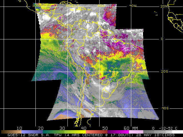
CIMSS and ASPB Resume Generation of GOES Products for
South American Users: Cooperative Institute for Meteorological
Satellite Studies (CIMSS) and Advanced Satellite Products Branch (ASPB)
scientists have re-instituted production of various Geostationary
Operational Environmental Satellite (GOES) imagery and products for
South American users, in support of the Global Earth Observation System
of Systems (GEOSS) program (http://www.ssd.noaa.gov/PS/SATS/GOES/SA/).
Imager and Sounder data are being received from GOES-12, now on station
at 60W longitude, and are being archived at the University of
Wisconsin-Madison Space Science and Engineering Center (SSEC) Data
Center. Selections of both observed and derived product imagery are
being displayed at http://cimss.ssec.wisc.edu/goes/rt/goessa.php.
It is anticipated that production of imagery covering South America
will continue at CIMSS as long as usable data are available from
GOES-12. (J. P. Nelson III, CIMSS, 608-263-6013, T. Schreiner, CIMSS,
608-263-6754, T. Schmit, E/RA2, 608-263-0291, tim.j.schmit@noaa.gov, G.
Wade, E/RA2, 608-263-4743,gary.s.wade@noaa.gov)
 (Click image to enlarge)
Figure caption: GOES-12 Sounder Total Precipitable Water (TPW) Composite
Image centered at approximately 1700UTC on 28 May 2010. This image is
composed of four separate, hourly TPW images from (north to south,
nominal times) 1532UTC, 1631UTC, 1731UTC and 1831UTC.
Update on STAR and CIMSS Support of Eyjafjallajokull Volcanic Ash Monitoring: Brad Pierce has been asked to join the NOAA Volcanic Ash Science Team, which is part of the newly formed NOAA Volcanic Ash Working Group. The Science Team is composed of NOAA experts currently performing volcanic ash modeling and observation research and is charged with determining the limitations of current capabilities, identification of the major science issues and describing future efforts to improve volcanic ash observation and prediction. Dr. Pierce was recommended to join because of his background in both aerosol modeling and satellite observation research. (R.B. Pierce, E/RA2, 608-890-1892, brad.pierce@noaa.gov)
Manuscript on Improving Moisture Retrieval from Broadband IR Radiances Published: An manuscript entitled
"Improving moisture profile retrieval from broadband infrared radiances
with an optimized first-guess scheme" was published in Remote Sensing
Letters. Coauthors are Xin Jin and Jun Li (CIMSS). (Xin Jin,
Xin.Jin@ssec.wisc.edu, 608-890-0619; Jun Li, Jun.Li@ssec.wisc.edu,
608-262-3755)
ITEMS FOR THE DIVISION CHIEF, CoRP:
CIMSS and ASPB Continue NWS Collaborations on Satellite-based Products: On May 27, 2010, as part of the GOES-R Proving Ground's Hazardous Weather Testbed (HWT), R. Aune (STAR) and J. Gerth (Cooperative Institute for Meteorological Satellite Studies, CIMSS) worked an eight hour shift at National Weather Service Forecast Office in Sullivan, Wisconsin to learn how CIMSS satellite-based products are used in the severe weather warning process. Feedback was obtained on how CIMSS convective initiation (CI) and nearcasting products are used to identify and track the potential for severe weather. These satellite based products are used in conjunction with forecast model output, satellite imagery and lightning data within the Advanced Weather Information Processing System (AWIPS) environment to identify thunderstorm cells with the best potential for producing severe weather. Although a few minor problems were identified, in general, the products were found to be a very useful contribution to the severe weather warning process. (R. Aune, E/RA2, 608-262-1071, J. Gerth, CIMSS, 608-263-4942)
CIMSS participation in NOAA Hazardous Weather Testbed: The Cooperative Institute for Meteorological Satellite Studies (CIMSS) will begin week three of a five week period of participation in the NOAA Hazardous Weather Testbed (HWT) supporting GOES-R Proving Ground activities. CIMSS is providing University of Wisconsin convective initiation (UWCI), overshooting-top/enhanced-V, and Weather Research and Forecasting (WRF) Advanced Research WRF (ARW) model-simulated Advanced Baseline Imager (ABI) radiances for the Advanced Weather Information Processing System (AWIPS) terminals as proxies for future GOES-R ABI decision support products. Two CIMSS scientists participate each week, working directly with four NWS forecasters. The goal is to provide this additional information to forecasters as they are involved in real-time or archived convective events while including all other sources of decision support (radar, mesonet, wind profiler, etc.) normally available in warning process. In addition, forecasters are using output from a new, advanced radar algorithm and GOES-R Geostationary Lightning Mapper (GLM) proxy lightning data. The purpose is to see how satellite decision support would be folded into an end-to-end warning process. During the first two weeks of participation, UWCI has been viewed very favorably as a way to hone in on locations where active convective is first forming, providing advanced lead time. This allowed forecasters to access GLM proxy cloud-to-cloud lightning in conjunction with GOES imager based convective initiation/cloud-top cooling within AWIPS. Cloud-to-cloud lightning was shown to first occur at first indication of cloud-top cooling in this case. Daily updates of the NOAA HWT CIMSS Proving Ground activity are at http://goesrhwt.blogspot.com. An overview of decision support products is at http://cimss.ssec.wisc.edu/goes_r/proving-ground/SPC/SPC.html. (W. Feltz, CIMSS, 608-265-6283, T. Schmit, E/RA2, 608-263-0291)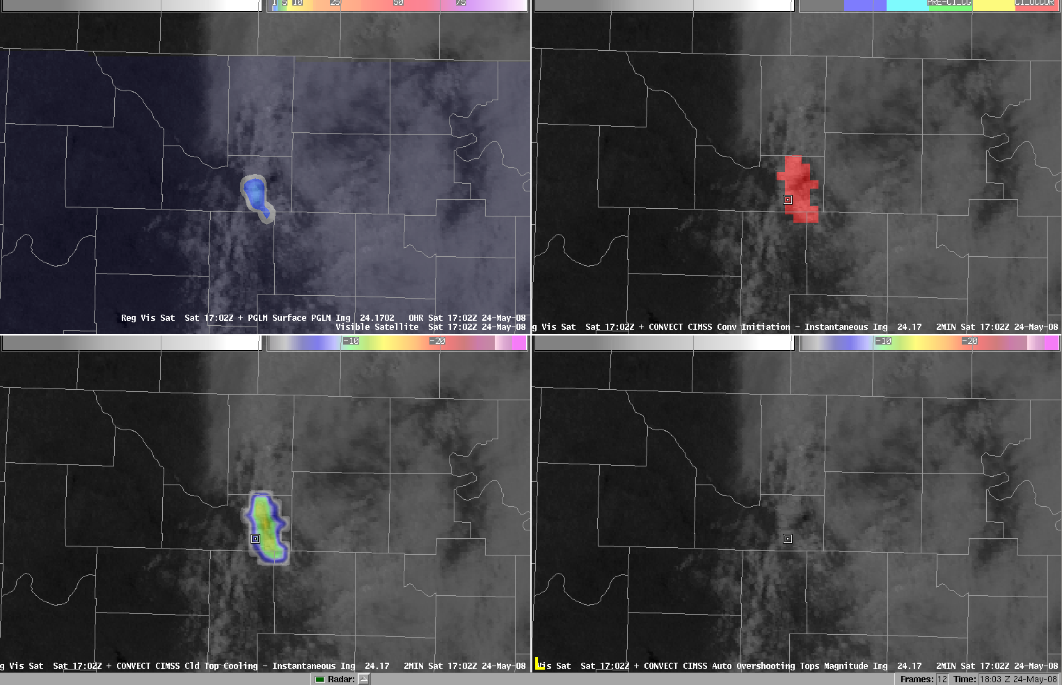 (Click image to enlarge)
VISITORS:
Barrientos visits ASPB: Dr. Celso Barrientos, branch chief of the Marine Ecosystems Branch (MEB), Satellite Oceanography and Climatology Division (SOCD), NESDIS Center for Satellite Applications and Research (StAR), visited with staff of the StAR Advanced Satellite Products Branch (ASPB) in Madison, WI on 27 May 2010. ASPB members discussed their research work at the Cooperative Institute for Meteorological Satellite Studies (CIMSS), on the University of Wisconsin-Madison campus, and provided Dr. Barrientos a good look at many of the resources available there during a building tour. (A. Heidinger, E/RA2, 608-263-6757, andrew.heidinger@noaa.gov; T. Schmit, E/RA2, 608-263-0291, tim.j.schmit@noaa.gov; G. S. Wade, E/RA2, 608-263-4743, gary.s.wade@noaa.gov)
NEXT WEEK:
LOOKING AHEAD:
| Archived Weeklies Page | Submit a report item |