
[ Archive ]

|
ASPB and CIMSS Weekly Report
[ Archive ] |
|
IN THE PRESS:
ITEMS FOR THE ADMINISTRATOR:
ITEMS FOR THE ASSISTANT ADMINISTRATOR:
ITEMS FOR THE OFFICE DIRECTOR, STAR:
PCW Users and Science Team Meeting: Environment
Canada held a Polar Communication and Weather (PCW) satellite mission
Users and Science Team meeting on June 16, 2010. Mike Kalb, Andy
Heidinger, Pablo Clemente-Colón, and Jeff Key participated via phone.
The PCW satellite mission is a concept for two “pseudo-geostationary”
satellites over the Arctic, with the launch of the first satellite in
2016. PCW will carry an imager similar to that planned for GOES-R but
with more channels in the longwave infrared region. (J. Key, E/RA2,
608-263-2605, jkey@ssec.wisc.edu)
Archived GOES-R Volcanic Ash Retrievals Provided to London Volcanic Ash Advisory Center: Volcanic ash products (ash height, mass loading, and effective particle radius), developed for the next generation Geostationary Operational Environmental Satellite (GOES-R), were provided to the London Volcanic Ash Advisory Center (VAAC) for detailed post event analysis of the Eyjafjallajokull eruption April 14-19, 2010 in Iceland. Near real-time GOES-R volcanic ash products are available for Iceland at http://cimss.ssec.wisc.edu/goes_r/proving-ground/geocat_ash/. (M. Pavolonis, E/RA2, 608-263-9597, Mike.Pavolonis@noaa.gov)
ITEMS FOR THE DIVISION CHIEF, CoRP:
Data and Analysis on a Recent GOES Imager Anomaly: T. Schmit provided both data and analysis on a recent Geostationary Operational Environmental Satellite (GOES)-12 Imager ‘cycle slip’ (which is a ‘mispointing’ of the primary mirror). This was provided to both NOAA/NESDIS and the instrument vendor to be used to resolve a GOES Incident Report (GIR). This event occurred between 09:15:48 UTC and 11:09:45 UTC on May 26th. The data were provided by the Space Science and Engineering Center (SSEC) Data Center. (T. Schmit, E/RA2, 608-263-0291)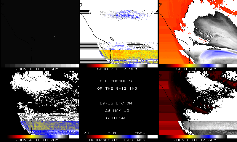 (Click image to enlarge)
CIMSS VISIT Activities: The Virtual Institute for Satellite Integration Training (VISIT) distance learning lessons "Basic Satellite Principles" (http://rammb.cira.colostate.edu/visit/basic.html) and "Interpreting Satellite Signatures" (http://rammb.cira.colostate.edu/visit/sat_signatures.html) were led by S. Lindstrom of the Cooperative Institute for Meteorological Satellite Studies (CIMSS) on June 16 and 17, 2010. Staff from the National Weather Service forecast office at Sioux Falls, South Dakota and the NOAA Unmanned Aircraft Systems Program participated in the VISIT lessons. (S. Lindstrom, CIMSS, 608-263-4425)
Manuscript on Land Surface Emissivity Algorithm for GOES-R Submitted: A manuscript titled "Land surface emissivity
from high temporal resolution geostationary infrared imager radiances -
I: Methodology and simulation studies" was submitted to the Journal
of Geophysical Research - Atmospheres. Co-authors are Jun Li,
Zhenglong Li, Xin Jin (CIMSS), Tim Schmit, Lihang Zhou, and Mitch
Goldberg (STAR/NESDIS). (Jun Li, CIMSS, 608-262-3755,
Jun.Li@ssec.wisc.edu)
VISITORS:
NEXT WEEK:
LOOKING AHEAD:
| Archived Weeklies Page | Submit a report item |